
Progression of danger roses for the Salt Lake mountains for 3/23 - 3/29. (Click on the day of the week for the archived forecast for that day.)
Friday Saturday Sunday Monday Tuesday Wednesday Thursday


 Considerable Considerable Moderate Moderate Considerable Moderate Moderate
 Summary - Small amounts of dense storm snow early in the period followed by increasingly stable conditions. Rain to nearly 10,000' on 3/23 creates a stout 2-6" frozen crust that bridgesweaker layers underneath.
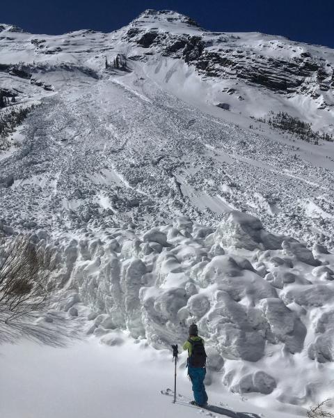
Friday March 23 - A signficant number of wet slabs were reported. These were the result from Thursday's drenching rains to nearly 10,000'. Most of these slides were from control work, but one natural in Days Fork was also reported thta broke into old faceted snow from early February. [Drew Stiremanphoto]
Saturday March 24 - A few inches of dense snow, and the damp snowpack continues to cool, and gain strength, as temperatures drop.
SundayMarch 25 - Transition day as a small storm system moves in late in the day. By Monday morning 2-4" of new, dense snow are reported in the Salt Lake and park City mountains.
Monday/Tuesday March 26/27 - Cool high pressure moves in with clear skies and light winds. Minimal avalanche activity reported with sluffingin the dry, loose snow as well as minor wet activity on solar aspects.
A glide avalanche is reported from Broads Fork. This slide most likely ran late the previous week during the period of heavy rains. [Mark White photo]
Wednesday March 28 - Winds increase and deposit small pockets of fresh wind drifts at the mid and upper elevations.
Thursday March 29 - Quiet conditions with only minor wet loose avalanche activity reported.


