25th Annual Black Diamond Fall Fundraising Party
Thursday, September 13; 6:00-10:00 PM; Black Diamond Parking Lot

25th Annual Black Diamond Fall Fundraising Party
Thursday, September 13; 6:00-10:00 PM; Black Diamond Parking Lot
| Advisory: Provo Area Mountains | Issued by Drew Hardesty for Tuesday - March 13, 2018 - 7:42am |
|---|
 |
special announcement How does an avalanche accident happen? What is it like to be caught? What can we learn? Read a first-hand account of the avalanche accident in the Meadow Chutes that happened on January 26th. The full accident report can be found here. We couldn't get out on the snow without the great support from Polaris, Ski Doo, and Arctic Cat as well as KTM and Timbersled. Our local dealers make it happen. Tri-City Performance, Weller Recreation, Northstar's Ultimate Outdoors, Big Pine and Morgan Valley Polaris. We use these machines to monitor the snowpack across the state of Utah. We also use these machines to teach life-saving classes. |
 |
current conditions Skies are partly cloudy. The winds backed to the south around dinnertime last night and are blowing 10-15mph with gusts to 20. Overnight lows are thankfully a touch cooler than the night before and are in the low to mid-30s. All but due north mid and upper elevation snow surfaces will be crusted this morning. Decent quasi-corn is found mid-morning on the southerly aspects while soft turns in upper elevation cold snow are becoming an increasingly rare commodity. Chris Covington and I have a few notes from our outing yesterday here. |
 |
recent activity A very close call occurred in Little Pine Chute in mid-LCC yesterday just before noon. Two skiers part of the way down the couloir had a natural wet sluff cascade down from a few hundred feet above. One person was dragged two hundred feet down the chute, lost a ski and suffered shoulder damage. They were able to get out on their own. Powderbirds noted two very large naturals out of southeast facing Box Elder Peak (Tibble Fork side) that most likely occurred yesterday during the heat of the day. |
| type | aspect/elevation | characteristics |
|---|


|


|

LIKELIHOOD
 LIKELY
UNLIKELY
SIZE
 LARGE
SMALL
TREND
 INCREASING DANGER
SAME
DECREASING DANGER
|
|
description
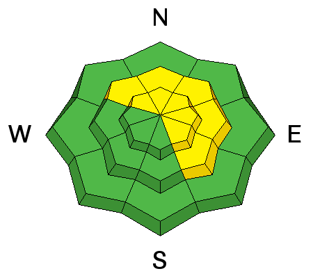
We've seen a few close calls across the range with skiers and snowmobilers triggering very large avalanches up to 5' deep in recent days. They are occurring in predominantly (but not limited to) northeast to southeast facing slopes in the mid and upper elevations in steep thin rocky terrain or in more heavily wind loaded areas. Suspect layering includes the early February faceted layers and the depth hoar at the ground. These for the most part are unsurvivable. |
| type | aspect/elevation | characteristics |
|---|


|


|

LIKELIHOOD
 LIKELY
UNLIKELY
SIZE
 LARGE
SMALL
TREND
 INCREASING DANGER
SAME
DECREASING DANGER
|
|
description
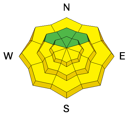
Wet Avalanches: As mountain temperatures skyrocket today, the snow will quickly thaw again and become wet and sloppy. Natural and human triggered wet loose (and potentially wet slab avalanches) are likely on the steepest aspects of all the sunlit slopes (and lower elevation shady ones). This is an easy problem to avoid. When the snow surface becomes damp and unsupportable or you start seeing roller balls cascading down from above, it's time to change to a cooler, more shady aspect. Cornices are increasingly sensitive with the sun and warm weather and often break back further than expected. Give them a wide berth and avoid travel below them. They may also - if large enough - be enough of a trigger to pry out deeper avalanches below. Roof-avalanches: Buildings are starting to shed their winter snow, so look up and avoid travel below steep roofs. |
 |
weather The ridge of high pressure moves off to the east as a large scale Pacific trof begins to cradle the west. A series of storms move through this week and into the weekend will bring snowfall to the moutains but details are shy at this time. For today, we'll see increasing clouds and southerly winds with mountain temps warming to the mid to upper 30s along the higher ridgelines...and in the ballpark of 50°F in the mid-elevations. |
| general announcements CLICK HERE FOR MORE GENERAL INFO AND FAQ The UAC has new support programs with Outdoor Research and Darn Tough. Support the UAC through your daily shopping. When you shop at Smith's, or online at Outdoor Research, REI, Backcountry.com, Darn Tough, Patagonia, NRS, Amazon, eBay a portion of your purchase will be donated to the FUAC. See our Donate Page for more details on how you can support the UAC when you shop. Benefit the Utah Avalanche Center when you buy or sell on eBay - set the Utah Avalanche Center as a favorite non-profit in your eBay account here and click on eBay gives when you buy or sell. You can choose to have your seller fees donated to the UAC, which doesn't cost you a penny This information does not apply to developed ski areas or highways where avalanche control is normally done. This advisory is from the U.S.D.A. Forest Service, which is solely responsible for its content. This advisory describes general avalanche conditions and local variations always occur. |