25th Annual Black Diamond Fall Fundraising Party
Thursday, September 13; 6:00-10:00 PM; Black Diamond Parking Lot
25th Annual Black Diamond Fall Fundraising Party
Thursday, September 13; 6:00-10:00 PM; Black Diamond Parking Lot
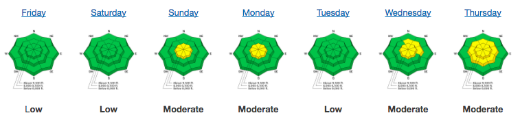
| Advisory: Provo Area Mountains | Issued by Greg Gagne for Friday - February 16, 2018 - 7:33am |
|---|

|
bottom line A MODERATE avalanche hazard exists for fresh wind drifts at the upper elevations. An isolated hazard for triggering deeper, persistent slab avalanches on north through northeast slopes at the upper elevations.
|
 |
special announcement Episode 5 of the UAC podcast "To Hell in a Heartbeat - A Conversation With Tom Diegel and Matt Clevenger About the 12.26.08 Full Burial on Little Water" is live. Matt and Tom about the avalanche documented in To Hell in a Heartbeat. Check it out on ITunes, Stitcher, the UAC blog. Tomorow - 6PM on February 17 at Alpine Distilling in Park City, attend a Know Before You Go Program then learn about whiskey while seeing how Alpine Distilling crafts local, award winning spirits including a cocktail with their Persistent (Weak Layer) Vodka. Also a raffle for a beacon, shovel, and probe. Contact [email protected] for details and reservations. |
 |
current conditions Temperatures this morning range throughout the low teens in the Provo mountains, and winds are westerly and moderate, gusting into the teens. Snow totals from the Provo mountains range from 3-8", with likely higher amounts at upper elevations. Although Salt Lake mountain-centric, with three storms this past week, be sure to read our Week in Review as you make your weekend plans:
|
 |
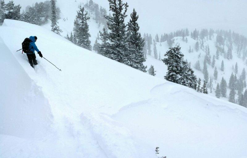
recent activity Wind loading in the upper elevations of the Provo mountains were reported from Thursday. Otherwise no recent reports from the Provo mountains. Further north, in the Salt Lake mountains all reported avalanche activity from the backcountry on Thursday involved new snow only, and included long-running sluffs and soft-slabs in wind-drifted terrain at the upper elevations. Avalanches required steeper slopes (> 35 degrees) and the fresh soft slabs were not breaking out very widely - up to about 25'. However, control work from a resort in the Park City mountains pried out a large wind slab that was 3' deep and 150' wide, running 450'. Image below from Trent Meisenheimer along LCC/BCC ridgeline showing soft-slab activity within the storm snow.
|
| type | aspect/elevation | characteristics |
|---|

|
|
LIKELIHOOD
 LIKELY
UNLIKELY
SIZE
 LARGE
SMALL
TREND
 INCREASING DANGER
SAME
DECREASING DANGER
|
|
description
Yesterday's moderate to occasionally strong west/northwest winds had plenty of 6% density snow to work with, creating fresh drifts at the upper elevations. Although these drifts will be less sensitive today, steep wind-loaded slopes should be avoided. Increasing winds out of the southwest today will create a new batch of fresh drifts, especially along upper elevation ridges. Although you are most likely to find these drifts on leeward aspects facing north through east, cross-loading onto any aspect is possible. |
| type | aspect/elevation | characteristics |
|---|

|
|
LIKELIHOOD
 LIKELY
UNLIKELY
SIZE
 LARGE
SMALL
TREND
 INCREASING DANGER
SAME
DECREASING DANGER
|
|
description
Small storms and wind events this past week slowly loaded the weak snowpack at the upper elevations. Our season-long persistent slab weaknesses have been dormant the past two weeks, however the added loads this past week may be enough for them to become reactive once again. Although triggering one of these deeper slides is probably unikely, any avalanche failing on weak sugary snow down near the ground would be quite large - up to 1-3' deep and breaking out very widely. Yesterday, my longtime touring companion Bob Frey and I were looking at the snowpack, focusing on this increasingly-deeper persistent weakness in the Salt Lake area mountains. See the discussion from our field work in this video below: The good news is that Thursday's storm created stellar riding conditions, providing plenty of safe options outside of the terrain harboring the weakest snow. |
 |
weather Fresh snow and sunshine make it a good day to call in well. Temperatures will start out comfortably cool this morning, rising into the 30's by the afternoon. Winds will be out of the southwest/west, and increasing throughout the day, blowing in the teens at mid elevations, and into the 20's mph at upper elevations. By sunset gusts could reach the 30's and 40's mph. Skies will start out clear, with a few passing clouds. Partly cloudy and windy overnight as a system rides by to our north. The weather models are currently suggesting the possibility of a very significant storm system for late this weekend. |
| general announcements CLICK HERE FOR MORE GENERAL INFO AND FAQ The UAC has new support programs with Outdoor Research and Darn Tough. Support the UAC through your daily shopping. When you shop at Smith's, or online at Outdoor Research, REI, Backcountry.com, Darn Tough, Patagonia, NRS, Amazon, eBay a portion of your purchase will be donated to the FUAC. See our Donate Page for more details on how you can support the UAC when you shop. Benefit the Utah Avalanche Center when you buy or sell on eBay - set the Utah Avalanche Center as a favorite non-profit in your eBay account here and click on eBay gives when you buy or sell. You can choose to have your seller fees donated to the UAC, which doesn't cost you a penny This information does not apply to developed ski areas or highways where avalanche control is normally done. This advisory is from the U.S.D.A. Forest Service, which is solely responsible for its content. This advisory describes general avalanche conditions and local variations always occur. |