25th Annual Black Diamond Fall Fundraising Party
Thursday, September 13; 6:00-10:00 PM; Black Diamond Parking Lot
25th Annual Black Diamond Fall Fundraising Party
Thursday, September 13; 6:00-10:00 PM; Black Diamond Parking Lot
| Advisory: Provo Area Mountains | Issued by Evelyn Lees for Sunday - April 16, 2017 - 5:29am |
|---|

|
bottom line The snowpack is frozen this morning and the avalanche danger is LOW. As the day heats, it will become possible to trigger wet loose sluffs with daytime heating. There are still a few isolated wind drifts that can be triggered on steep slopes along the ridge lines.
|
 |
special announcement Great news… so far there haven’t been any avalanche fatalities in Utah this winter! It has been 26 years since we’ve had a fatality-free winter. Let’s keep it that way and stay safe this spring. Our goal is for everyone to enjoy the Greatest Snow on Earth and come home safe every day. The final regular advisory will be today, Sunday, April 16. For the rest of the month we'll issue Friday updates for the central Wasatch Mountains and updates any time there is measurable snowfall; however, we will discontinue issuing avalanche danger ratings after today. Although we will be shutting down regular operations, we will continue to post observations through the end of the month as we receive them, so please do continue to send them to us. You can check the latest observations here. We also follow avalanche-related activity on Instagram - be sure to tag your photos with #utavy . |
 |
current conditions Under mostly clear skies, it was another OK overnight refreeze in the Provo area mountains, with temperatures this morning mostly in the low to mid 30s F, and probably in the upper 20s at the higher elevations. Winds have shifted to the southwesterly and are light, averaging 5 - 10 mph. Week in Review [Detailed Version] A storm system entered the region this past weekend, with warm temperatures and a high rain/snow line on Saturday April 8th. A cold front with an ample moisture supply late Saturday night and well into the day on Sunday provided nearly 18-24" in the Cottonwoods and Ogden mountains, with 8-15" along the Park City ridgeline. The Provo mountains recorded 3-6". Limited avalanche activity was reported with this storm, with a few slides breaking at a graupel interface of the old snow surface, or within a density inversion within the storm snow. Monday brought clearing skies, but cool temperatures kept wet activity to a minimum. A short-duration wind event on Tuesday morning created pockets of wind drifts in isolated terrain, and a wind slab avalanche was triggered by a party of skiers hiking uphill at Snowbird Ski Resort. Another small wind drift was triggered in White Pine in Little Cottonwood canyon. Warming temperatures highlighted Wednesday and Thursday, but wet activity was minimal. A dry cold front entered the region Thursday evening, providing a solid refreeze of the snowpack by Friday morning. |
 |
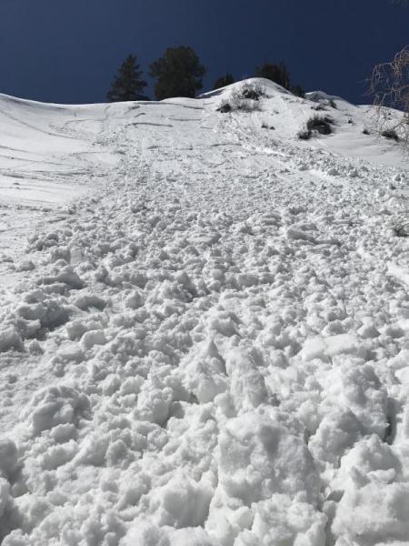
recent activity One interesting slab avalanche was reported yesterday, triggered on Cinder Chutes at 1:30 in the afternoon on a steep East facing slope at 8800'. I am thinking it may have been a wind slab from last week that was warming for the first time.
|
| type | aspect/elevation | characteristics |
|---|

|

|
LIKELIHOOD
 LIKELY
UNLIKELY
SIZE
 LARGE
SMALL
TREND
 INCREASING DANGER
SAME
DECREASING DANGER
|
|
description
Cold air temperatures and mostly clear skies gave the snowpack a decent refreeze last night. While temperatures are forecast to be about 10 degrees warmer than yesterday, they still won't be as warm as last week. Because the snowpack has gone through so many melt-freeze cycles, I would expect limited wet snow avalanche activity today. But if the steep slope you're on gets wet and sloppy, it will be possible to push and start small wet loose sluffs. Early in the day, the snow will be hard and icy, so use caution on steep slopes. The other thing to look for and avoid any old wind slabs that formed last week during a period of strong southerly winds. These would mostly be along ridge lines, on northwest through easterly facing slopes. Watch the video below about things to watch for this spring. |
 |
weather Today will be another beautiful spring day, with increasing clouds through out the day. Temperatures about 10 degrees warmer than yesterday, warming into the low to mid 50s F at 8,000' and the mid 40s at 10,000'. The southwesterly winds will remain light, averaging 5-10 mph. The next chance for a shot of snow is late Tuesday into Wednesday. |
general announcements
|