| Please join us at the 23rd annual Black Diamond Fall Fundraiser Party Thursday Sept 15. Tickets are on sale now here, at the Black Diamond store & at REI. Special bonus raffle for online ticket purchasers! |  |

| Please join us at the 23rd annual Black Diamond Fall Fundraiser Party Thursday Sept 15. Tickets are on sale now here, at the Black Diamond store & at REI. Special bonus raffle for online ticket purchasers! |  |
| Advisory: Provo Area Mountains | Issued by Drew Hardesty for Saturday - February 13, 2016 - 7:05am |
|---|
 |
special announcement Check out our Garage Sale! Chock full of sweet backcountry gear - you can find the goods on our Facebook page here - Tuesday, February 16th - Companion Rescue Clinic at Weller Recreation in Kamas from 6:30-9pm. For more info HERE. WBSKIING: Steve Achelis has released his updated Wasatch Backcountry Skiing desktop webpage - wbskiing.com Blog post - Guest blog post by George Vargyas, MD - Avalanche Trauma Mortality and Helmet Use. It may surprise you. |
 |
current conditions The ridge of high pressure is finally breaking down and we're starting to see some moisture streaming in from the west. Not that the junk in the valley is necessarily going anywhere, but the pattern change will at least allow for some weaker storms to chip away at the thing until things mix out hopefully by late Monday. West to southwest winds picked up and are blowing 10-15mph with gusts to 25. Mountain temperatures are interesting. Certainly the lower elevations are in the low 20s; the highest elevations are in the upper 20s to low 30s; but a number of stations in the mid-elevation "thermal belt" have stubbornly warm temperatures that are loathe to dip below freezing. Many have had two nights well above freezing and some haven't seen temperatures below 32°F since the 8th. Sure you'll find crusts out there, but the crusts will likely be superficial in nature. Wind, rime, and melt-freeze crusts dominate the snow surfaces, but you can still find sanity in the mid-elevation sheltered terrain. |
 |
recent activity None reported. |
| type | aspect/elevation | characteristics |
|---|


|


|

LIKELIHOOD
 LIKELY
UNLIKELY
SIZE
 LARGE
SMALL
TREND
 INCREASING DANGER
SAME
DECREASING DANGER
|
|
description
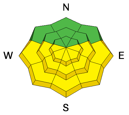
Most of the initial wet activity ran last weekend into the early part of the week, but I'm concerned with the poor refreeze at many of the mid-elevations from the last two nights. Some stations in the mid-elevation band haven't dipped below freezing since the 8th. This isn't to say that long wave radiation under clear skies hasn't cooled the snow surfaces enough to refreeze, it's only to say that it's possible that some crusts may be superficial - like a wolf in sheep's clothing - while free water percolates down into the pack, looking for crusts or weak layers to pool above or saturate, leading to wet slab conditions. I wasn't the only one to find punchy, unsupportable snow on some south to west mid-elevation terrain yesterday, particularly in thinner areas. It's not a good sign. Simple ski pole tests should also tell the tale. If you're punching through today, finding free water running and pooling at interfaces, or getting collapsing in the isothermal regime, change to cooler aspects or seek low angle terrain. You'll see one of the things we do to gauge wet slab potential in regards to pooling water in the video from the Park City ridgeline, below, with the AAI Level 3 avalanche class. |
| type | aspect/elevation | characteristics |
|---|


|


|

LIKELIHOOD
 LIKELY
UNLIKELY
SIZE
 LARGE
SMALL
TREND
 INCREASING DANGER
SAME
DECREASING DANGER
|
|
description
Down the road -
|
 |
weather We'll have some increasing cloud cover this morning as the first of two weak disturbances blow through northern Utah. We'll have moderate west to southwest winds along the ridgelines. Temperatures are cooling a bit and should at or below freezing at 10,000' with temps in the 40s at 8000'. Skies may start to clear a bit in the early afternoon. The 2nd wave arrives tomorrow, ushering in even cooler air along with moderate to strong northwest winds. We may see "storm totals" of 1-3" from midday Sunday through late Monday. Shortwave ridging moves back in for Wednesday with another stronger system on tap for Thursday. |
general announcements
|
Advisory Hotline: (888) 999-4019 | Contact Information