| Please join us at the 23rd annual Black Diamond Fall Fundraiser Party Thursday Sept 15. Tickets are on sale now here, at the Black Diamond store & at REI. Special bonus raffle for online ticket purchasers! |  |

| Please join us at the 23rd annual Black Diamond Fall Fundraiser Party Thursday Sept 15. Tickets are on sale now here, at the Black Diamond store & at REI. Special bonus raffle for online ticket purchasers! |  |
| Advisory: Provo Area Mountains | Issued by Drew Hardesty for Sunday - February 7, 2016 - 7:05am |
|---|
 |
special announcement Tuesday February 9th - Fireside Chat at 7 p.m. at Black Diamond. UAC Forecaster Brett Kobernik will discuss current conditions and his own avalanche involvement on the Skyline from last week. Wednesday February 10th - Avalanche Clinic for Ice Climbers at 6 p.m. at Sandy Momentum climbing gym. For more info click HERE. |
 |
current conditions Skies are partly cloudy. Mountain temperatures are in the mid to upper 20s. West to northwesterly winds have awakened, now blowing 15-20mph with gusts to 35. 11,000' winds: 35-40mph with gusts to 55. |
 |
recent activity Steep southerlies went off yesterday, at least in upper Little Cottonwood. Warming temps, direct sun, and light wind - all conspirators in the loose wet and pockets of wet slab cycle in the steepest sunny terrain. Wet slides ran not full track, but three-quarters track and left debris piles deep enough to bury you. (photo: D.Jackson, UDOT LCC).
|
| type | aspect/elevation | characteristics |
|---|


|


|

LIKELIHOOD
 LIKELY
UNLIKELY
SIZE
 LARGE
SMALL
TREND
 INCREASING DANGER
SAME
DECREASING DANGER
|
|
description
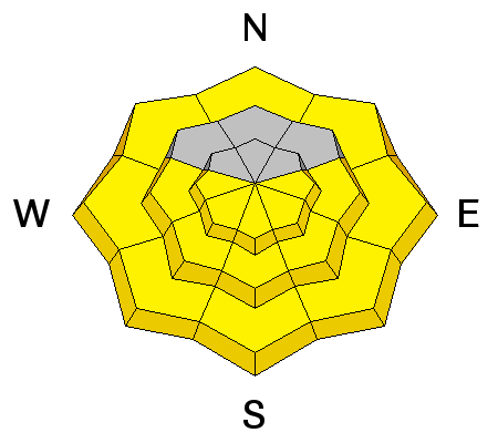
Watch for wind slab development today, particularly along the highest ridgelines. Soft wind drifts of up to 12-18" may be particularly sensitive on the steep south to east facing terrain and may be triggered on approach or at a distance. These smooth, rounded drifts should be obvious along the lee of ridgelines and other terrain features. Shooting cracks and collapsing are immediate signs of instability. Click on the 'i' near the info-graphic for more info on Wind Slabs. |
| type | aspect/elevation | characteristics |
|---|


|


|

LIKELIHOOD
 LIKELY
UNLIKELY
SIZE
 LARGE
SMALL
TREND
 INCREASING DANGER
SAME
DECREASING DANGER
|
|
description
Low probability, High consequence. The last human triggered slide was in No Name on Tuesday; the fatality along the Park City ridgeline was a week ago. These slides have generally been 2-4' deep and particularly tricky as there have often been other tracks on the slope or similar, adjacent paths skiied or ridden without retribution. They're also particularly tricky because by now they show little signs of instability - no cracking, collapsing; they're not hair trigger. You could dig a pit in one area, find stable snow and then commit to adjacent terrain that had previously avalanched and has a completely different depth and structure. Pull out your new avalanche probe (or Avatech SP2), throw away the nylon bag, and probe around snowpack depths. In general, the stable, intact depths are roughly 150-200cm or more; the repeater (conditionally unstable) avalanche snowpacks sit at 70-120cm (with fairly obvious weak snow at the base).* These are more prominent on northwest to north to easterly facing slopes above 9000' and tend to become more stressed with significant weather events. Trigger points often include thin, rocky areas. *The fine print - Side effects of putting oneself into avalanche terrain to determine structure/stability (repeaters are in avalanche terrain after all), include collapsing the slope and being caught and carried. More than one avalanche professional, aspirant, or keener has had their suspicions confirmed in this way. Other side effects do not include rashes, swelling, or baldness, though may include nausea, vertigo, broken bones, or burial. Click on the 'i' near the info-graphic for more info on Deep Slabs. |
| type | aspect/elevation | characteristics |
|---|


|


|

LIKELIHOOD
 LIKELY
UNLIKELY
SIZE
 LARGE
SMALL
TREND
 INCREASING DANGER
SAME
DECREASING DANGER
|
|
description
Yesterday's wet avalanche forecast was a crapshoot. Blow the weather forecast, blow the wet avalanche forecast. For today, expect:
Truth-be-told, the now-cast is pretty useful. Warning signs -
It's a timing thing - too early on the east, south, and west and you'll find breakable and trapdoor crust. Too late and you're either the trigger or in the line of fire for wet avalanches. |
 |
weather We'll have at times clear skies and perhaps a few high level clouds moving through. Winds should remain gusty out of the northwest and north. Temperatures will reach near or just exceed 30°F at 10,000', the low-40s at 8000'. Looks like high pressure builds over the next week with significant warming expected by Monday into Tuesday. Tuesday's 10,000' temps soar to 40°F. In the meantime, the low density powder on the snow surface may start to facet and become weak over the next several days. The forecasters at Hatcher Pass call it "square powder". Image: Jed Workman from HPAC.
|
| general announcements Remember your information can save lives. If you see anything we should know about, please participate in the creation of our own community avalanche advisory by submitting snow and avalanche conditions. You can also call us at 801-524-5304, email by clicking HERE, or include #utavy in your tweet or Instagram. To get help in an emergency (to launch a rescue) in the Wasatch, call 911. Be prepared to give your GPS coordinates or the run name. Dispatchers have a copy of the Wasatch Backcountry Ski map. Backcountry Emergencies. It outlines your step-by-step method in the event of a winter backcountry incident. If you trigger an avalanche in the backcountry, but no one is hurt and you do not need assistance, please notify the nearest ski area dispatch to avoid a needless response by rescue teams. Thanks. Salt Lake and Park City – Alta Central (801-742-2033), Canyons Resort/PCMR Dispatch (435)615-1911 Snowbasin Resort Dispatch (801-620-1017), Powder Mountain Dispatch (801-745-3772 x 123). Sundance Dispatch (801-223-4150) EMAIL ADVISORY If you would like to get the daily advisory by email you will need to subscribe here. DAWN PATROL Hotline updated daily by 5-530am - 888-999-4019 option 8. Twitter Updates for your mobile phone - DETAILS UDOT canyon closures: LINK TO UDOT, or on Twitter, follow @UDOTavy, @CanyonAlerts or @AltaCentral Utah Avalanche Center mobile app - Get your advisory on your iPhone along with great navigation and rescue tools. Powderbird Helicopter Skiing - Blog/itinerary for the day Lost or Found something in the backcountry? - http://nolofo.com/ To those skinning uphill at resorts: it is your responsibility to know the resort policy on uphill travel. You can see the uphill travel policy for each resort here. IMPORTANT: Before skinning or hiking at a resort under new snow conditions, check in with Ski Patrol. Resorts can restrict or cut off access if incompatible with control and grooming operations. Benefit the Utah Avalanche Center when you shop from Backcountry.com or REI: Click this link for Backcountry.com or this link to REI, shop, and they will donate a percent of your purchase price to the UAC. Both offer free shipping (with some conditions) so this costs you nothing! Benefit the Utah Avalanche Center when you buy or sell on ebay - set the Utah Avalanche Center as a favorite non-profit in your ebay account here and click on ebay gives when you buy or sell. You can choose to have your seller fees donated to the UAC, which doesn't cost you a penny. This information does not apply to developed ski areas or highways where avalanche control is normally done. This advisory is from the U.S.D.A. Forest Service, which is solely responsible for its content. This advisory describes general avalanche conditions and local variations always exist. |
Advisory Hotline: (888) 999-4019 | Contact Information