| Please join us at the 23rd annual Black Diamond Fall Fundraiser Party Thursday Sept 15. Tickets are on sale now here, at the Black Diamond store & at REI. Special bonus raffle for online ticket purchasers! |  |

| Please join us at the 23rd annual Black Diamond Fall Fundraiser Party Thursday Sept 15. Tickets are on sale now here, at the Black Diamond store & at REI. Special bonus raffle for online ticket purchasers! |  |
| Advisory: Provo Area Mountains | Issued by Evelyn Lees for Thursday - January 7, 2016 - 6:36am |
|---|
 |
special announcement You've got your choice of two great events tonight: 6:00pm Tonight at Snowbird’s Wildflower Lounge the Utah Adventure Journal Speaker Series continues with a presentation from Chris Waddell. After a skiing accident in 1988 left Chris paralyzed from the waist down, Chris continued his outdoor passions and was named to the US Disabled Team less than two years later, winning medals in both the winter and summer Paralympic games, and summiting Mt. Kilimanjaro. Please join us for an amazing presentation by Chris who proclaims “It’s not what happens to you. It’s what you do with what happens to you." Check out the entire list of speakers here: https://goo.gl/ha05ir 7:00pm Tonight at The State Room, 4FRNT skis presents “Bevies For Avy’s” a fundraiser party to benefit the Utah Avalanche Center. Silent Auction, Short films, $3 beers from Bohemian Brewery and live music from Pixie and The Partygrass Boys! This is sure to be a great party and a great kick off for the Outdoor Retailer show! Tickets are $10 all proceeds go towards avalanche forecasting and education. For more details: https://goo.gl/AM2kAs |
 |
current conditions Another wave of snow on a southwesterly flow came through overnight, favoring the Ogden and Provo area mountains with an additional 3 to 7” of dense snow. The Park City side received an additional 2 inches of snow, and the Cottonwoods 2 to 4”.
Multi-day totals are now up 12 inches of snow with up to 1.5" water in parts of the Ogden and Provo area mountains, 6 to 10” in the Cottonwoods, and 4” on the Park City side. This dense, track-erasing snow is creating marvelous turning and riding conditions, with low angle terrain especially filled in.
Skies are partly cloudy this morning, and it’s warm – temperatures are in the mid teens at 10,000’ and in the upper 20s at the lower elevations of the Provo area mountains. The southerly winds are light, with most stations averaging less than 10 mph. |
 |
recent activity There were few backcountry observations, but numerous reports of activity from the resorts. Periods of wind Tuesday night and yesterday produced sensitive wind slabs along the ridgelines. Both skier and explosive triggered slides, large enough to bury a person, were released in the Ogden and Provo area mountains, mostly wind slabs along ridgelines. Big Cottonwood Canyon snow safety personnel also reported wind slabs active with ski cuts. Loose wet sluffs continue to occur at the lower elevations in the Provo area mountains, with another round overnight.
|
| type | aspect/elevation | characteristics |
|---|


|


|

LIKELIHOOD
 LIKELY
UNLIKELY
SIZE
 LARGE
SMALL
TREND
 INCREASING DANGER
SAME
DECREASING DANGER
|
|
description
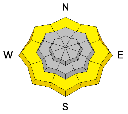
The new snow is bonding poorly to the slick wind and sun crusts and to the sugary faceted snow that was on the surface. This is becoming an issue where there is wind effected snow or on slopes that have received the greatest amounts of new snow. Expect to be able to trigger both wind slabs and sluffs today, and natural avalanches are possible. Also, watch for ANY uptick in wind speeds where you are or above you – some of the anemometers are slowed by riming this morning, so speeds are inaccurate. And the forecast speeds are just at the threshold of where they could start efficiently drifting the snow. The snow and water totals are starting to creep up in the Provo area mountains, so keep in mind the multi-day totals, not just the overnight hour totals.
|
| type | aspect/elevation | characteristics |
|---|


|


|

LIKELIHOOD
 LIKELY
UNLIKELY
SIZE
 LARGE
SMALL
TREND
 INCREASING DANGER
SAME
DECREASING DANGER
|
|
description
Wet Sluffs - at the low elevations, wet loose sluffs are still possible today on steep slopes, including road banks and creek bed walls. Wet sluffs have occurred mostly in the Provo area mountains the last few days and again overnight, but avoid soggy, wet snow on steep slopes through out the Wasatch mountains. Ice climbs in Provo canyon may be affected by wet, loose sluffs. |
| type | aspect/elevation | characteristics |
|---|


|


|

LIKELIHOOD
 LIKELY
UNLIKELY
SIZE
 LARGE
SMALL
TREND
 INCREASING DANGER
SAME
DECREASING DANGER
|
|
description
Our snowpack is complex enough there are several other issues to watch out for:
Deep Slab problem – in isolated places a slide could still break on the weak facets near the ground – think steep, rocky slopes with a shallow snowpack on mid and upper elevation slopes facing northwest through easterly.
Slopes that avalanched during the Christmas week avalanche cycle are fairly well filled in with new snow and wind drifted snow. Not only are they hard to identify, but now have a new slab on top of the old bed surface. |
 |
weather The last of the light snow falling this morning should diminish, leaving cloudy skies for the afternoon. An additional trace to 2” of snow is possible. 10,000’ temperatures will stay in the upper teens today. The southerly winds should remain light – in the 5 to 15 mph range, with gusts to 25, eventually shifting to a northerly direction. One final wave of snow is possible tonight into Friday – with another 2 to 4” expected. |
general announcements
|
Advisory Hotline: (888) 999-4019 | Contact Information