25th Annual Black Diamond Fall Fundraising Party
Thursday, September 13; 6:00-10:00 PM; Black Diamond Parking Lot
25th Annual Black Diamond Fall Fundraising Party
Thursday, September 13; 6:00-10:00 PM; Black Diamond Parking Lot
| Advisory: Ogden Area Mountains | Issued by Trent Meisenheimer for Sunday - April 15, 2018 - 6:35am |
|---|

|
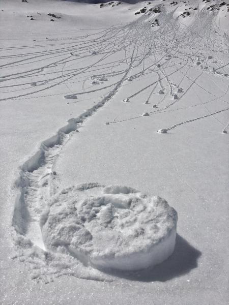
bottom line This morning we will start with a LOW avalanche danger on all aspects and elevations. However, with warming temperatures the danger for wet loose avalanches may quickly rise to MODERATE on all mid to upper elevation aspects. Keep an eye on the snow surface and notice if it's becoming damp or wet. The bulls eye clue to warming snow is rollerballs and pinwheels cascading down the mountain. If you're getting into extreme terrain today watch for icy slide-for-life conditions and always be on the lookout for windslabs.
|
 |
special announcement This is the last regular avalanche forecast. We will issue intermittent advisories for the Ogden mountains through the end of April everytime it snows. We will continue to post all observations so please keep sending those in. Mark Staples will be updating the avalanche forecast Tuesday morning.
|
 |
current conditions Under partly cloudy skies this morning the temperatures will be on the rise with warm air moving in from the south ahead of a decent cold front slated for late Monday. Current mountain temperatures are in the upper 20's °F at 9,000'. Winds have switched to west/southwest and are averaging 10-15 mph gusting into the 20's across the exposed ridges. The new snow from Friday has now settled into about 6" of creamy dense powder in the upper elevation northerly facing terrain. The strong April sun was out yesterday and has left a crust on almost all aspects and elevations that received direct sun. If you're planning on heading to steep upper elevation terrain there is icy slide-for-life conditions off the ridges and whippets, ice axe, and crampons will be good tools for today. Read more about the roller-coaster weather this past week in the Week in Review, a recapitulation of the avalanche activity and mountain weather. Thanks for all the support and suggestions for this feature. |
 |
recent activity Yesterday, backcountry observers noted many roller balls in the steep sunny terrain as well as minor loose wet activity. Mid elevations went through a natural wet loose cycle on the sunny aspects by mid day. None of these slides were large enough to bury a person. |
| type | aspect/elevation | characteristics |
|---|

|

|
LIKELIHOOD
 LIKELY
UNLIKELY
SIZE
 LARGE
SMALL
TREND
 INCREASING DANGER
SAME
DECREASING DANGER
|
|
description
The forecasted temperature for the 700 millibar (10,000' - 11,000') level in our atmosphere is supposed to rise to 37-40°F today. There will be plenty of warm air to get the snow surface damp/wet on all aspects and elevations. The wild card will be the cloud cover and the southerly winds, this may just keep the wet activity at bay and allow the snow surface to stay cold. However, if you're noticing the snow becoming damp and you're seeing pinwheels & roller balls cascading down the slope it's a sure bet the snow is warming and it's time to move to a colder aspect or lower your slope angle. Left photo: Shows a good example of why we call them pinwheels. Right photo: Roller balls on a steep NE.
|
 |
weather Clouds and southerly winds will begin to increase today ahead of a cold front slated for Monday afternoon. Mountain temperatures are expected to rise into the 40's & 50's at mid elevations. Winds will be from the west/southwest and are expected to increase into the 15-25 mph range gusting into 30's & 40's along the exposed ridges. Late tonight through Monday afternoon the southerly winds will continue to increase, averaging 25-35 mph gusting into 70's. It's likely we will see another dirt layer in the mountains as the southerly winds bring in dust from the desert. Late Monday, the cold front arrives , winds switch back to the north and temperatures drop. By Tuesday morning we could see 5-10" of new snow. |
| general announcements CLICK HERE FOR MORE GENERAL INFO AND FAQ The UAC has new support programs with Outdoor Research and Darn Tough. Support the UAC through your daily shopping. When you shop at Smith's, or online at Outdoor Research, REI, Backcountry.com, Darn Tough, Patagonia, NRS, Amazon, eBay a portion of your purchase will be donated to the FUAC. See our Donate Page for more details on how you can support the UAC when you shop. Benefit the Utah Avalanche Center when you buy or sell on eBay - set the Utah Avalanche Center as a favorite non-profit in your eBay account here and click on eBay gives when you buy or sell. You can choose to have your seller fees donated to the UAC, which doesn't cost you a penny This information does not apply to developed ski areas or highways where avalanche control is normally done. This advisory is from the U.S.D.A. Forest Service, which is solely responsible for its content. This advisory describes general avalanche conditions and local variations always occur. |