25th Annual Black Diamond Fall Fundraising Party
Thursday, September 13; 6:00-10:00 PM; Black Diamond Parking Lot
25th Annual Black Diamond Fall Fundraising Party
Thursday, September 13; 6:00-10:00 PM; Black Diamond Parking Lot
| Advisory: Ogden Area Mountains | Issued by Evelyn Lees for Saturday - February 17, 2018 - 7:11am |
|---|

|
bottom line The avalanche danger is CONSIDERABLE on steep, upper elevation north through easterly facing slopes with recent deposits of wind-drifted snow. A triggered wind drift may step down to a deeper weak layer, resulting in a large, dangerous avalanche. There is a MODERATE avalanche danger on wind drifted mid elevation slopes and steep sunny slopes if the snow heats up. Low angle, wind sheltered, shady slopes will have the best powder snow with less avalanche risk. Sunday and Monday - a winter storm with strong winds and heavy snowfall will increase the avalanche danger in all the mountains of northern and central Utah. Local avalanche forecasts are updated every morning.
|
 |
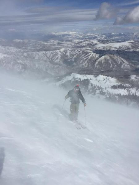
special announcement We are saddened to report that Orem resident Alexander Marra was killed in an avalanche today, Saturday, February 10, in Wyoming. He was skiing out-of-bounds at JHMR, and triggered a 2-foot deep slide that took him over cliffs. Our thoughts and sympathies go out to his family and friends. Accident Report. Episode 5 of the UAC podcast "To Hell in a Heartbeat - A Conversation With Tom Diegel and Matt Clevenger About the 12.26.08 Full Burial on Little Water" is live. Matt and Tom about the avalanche documented in To Hell in a Heartbeat. Check it out on ITunes, Stitcher, the UAC blog. |
 |
current conditions After 48 hours of well-behaved winds, speeds kicked up last night, especially at the upper elevations. At mid elevations, the southwesterly winds are averaging 10 to 20 mph, with gusts in the 30s. The upper elevations are where the real action is – on Mount Ogden, 35 to 49 mph averages, gusting in the 40s and 50s. Mountain temperatures range from the low teens to upper twenties. Riding conditions have improved quite a bit especially on low angle, higher elevation slopes. Approximate local storm totals from Thursday's storm: Ben Lomond: 4" |
 |
recent activity An excellent observation from Bill Brandt from yesterday. It was windy. Very windy, even at the lower elevations.
|
| type | aspect/elevation | characteristics |
|---|

|
|
LIKELIHOOD
 LIKELY
UNLIKELY
SIZE
 LARGE
SMALL
TREND
 INCREASING DANGER
SAME
DECREASING DANGER
|
|
description
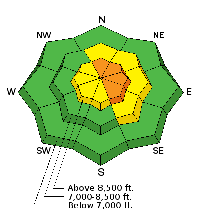
Today’s stronger winds have snow to drift and blow around. Wind drifts, known as wind slabs, often look smooth and rounded, and when you find one, they can be cracky, denser and deeper than the surrounding snow. As the winds were getting well down into the low to mid elevations yesterday, look for drifts at all elevations, and cross-loaded along gully walls, mid slope break overs and sub ridges. Avoid any wind drifts on steep slopes. The winds are significantly stronger at the upper elevations, so be aware of steep wind drifted slopes above – natural avalanches are possible. With fresh snow for the wind to move around, expect cornices to build along exposed ridgelines and terrain features today. These should be fairly sensitive and may break back further than you think they will. Give them a wide berth to avoid this problem. If you plan on riding in the Monte Cristo area, where snow totals are higher, keep a sharp eye out for red flags like cracking or collapsing and avoid wind loaded steep slopes as buried weak layers may be more reactive to the increased load. |
| type | aspect/elevation | characteristics |
|---|

|
|
LIKELIHOOD
 LIKELY
UNLIKELY
SIZE
LARGE
SMALL
TREND
INCREASING DANGER
SAME
DECREASING DANGER
|
|
description
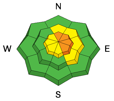
Buried faceted layers in the Ogden area snowpack are mostly dormant but, unfortunately, with faceted snow pesisting in the snowpack, mainly on NW, N, and NE facing slopes above 8500 feet, a small chance remains of triggering an avalanche into older snow. The added weight of wind drifted snow may be enough to tip the balanche on isolated slopes today. There is a lot of variability in the snowpack strength and depth, with facet layers both mid pack and near the ground. Slopes with a shallower snowpack tend to have weaker snow – including slopes that have slid one or more times this year. The buried surface hoar from 25 February is still on the radar for us and found more prominently on the east side of the Ogden mountain valleys, i.e. Monte Cristo. Cracking and collapsing are bulls-eye clues to instability, but not always present.
|
| type | aspect/elevation | characteristics |
|---|

|
|
LIKELIHOOD
 LIKELY
UNLIKELY
SIZE
 LARGE
SMALL
TREND
INCREASING DANGER
SAME
DECREASING DANGER
|
|
description
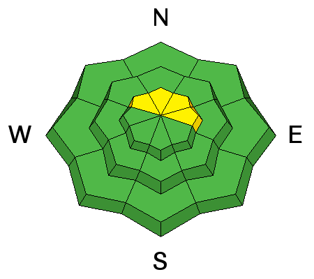
A few small wet loose sluffs are possible on steep, sunny slopes with daytime heating. |
 |
weather It will be warm and windy today, with temperatures nearing 30 at along the highest ridge lines and warming into the 40s at the low elevations. The west to southwesterly sinds will increase with elevation – 20 to 30 mph averages at mid elevations, with gusts in the 40s. The highest peaks will average to 40 mph, with gusts in the 60s. It will be very windy tonight and Sunday ahead of a strong cold front that should reach northern Utah late Sunday afternoon, bringing periods of snow through at least Monday night. 12 to 24” are possible. |
| general announcements CLICK HERE FOR MORE GENERAL INFO AND FAQ The UAC has new support programs with Outdoor Research and Darn Tough. Support the UAC through your daily shopping. When you shop at Smith's, or online at Outdoor Research, REI, Backcountry.com, Darn Tough, Patagonia, NRS, Amazon, eBay a portion of your purchase will be donated to the FUAC. See our Donate Page for more details on how you can support the UAC when you shop. Benefit the Utah Avalanche Center when you buy or sell on eBay - set the Utah Avalanche Center as a favorite non-profit in your eBay account here and click on eBay gives when you buy or sell. You can choose to have your seller fees donated to the UAC, which doesn't cost you a penny This information does not apply to developed ski areas or highways where avalanche control is normally done. This advisory is from the U.S.D.A. Forest Service, which is solely responsible for its content. This advisory describes general avalanche conditions and local variations always occur. |