25th Annual Black Diamond Fall Fundraising Party
Thursday, September 13; 6:00-10:00 PM; Black Diamond Parking Lot
25th Annual Black Diamond Fall Fundraising Party
Thursday, September 13; 6:00-10:00 PM; Black Diamond Parking Lot
| Advisory: Ogden Area Mountains | Issued by Trent Meisenheimer for Monday - February 5, 2018 - 6:30am |
|---|

|
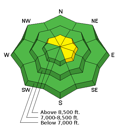
bottom line Today, we have a MODERATE danger for triggering a persistent slab avalanche on slopes that face northwest to east above 8,000' in elevation. The most suspect slopes will be the ones that are getting loaded by the wind and new snow. Human triggered avalanches 1-2' deep are possible. Additionally, shallow pockets of wind blown snow will be found along the upper elevation terrain features and will be most problematic in high consequence terrain. Lastly, damp push-alanches are possible in steep low to mid-elevation sheltered slopes that have remained warm for the past several days.
|
 |
special announcement The latest UAC podcast - "Recreating Like a Pro - A Conversation with IFMGA guide Anna Keeling" is live. This podcast will be ideal for anyone looking to pick up some tips and tricks from a professional mountain guide for recreating in the winter backcountry environment. New blog post - Stacking the Deck - a Hindsight 20/40 story |
 |
current conditions Mostly cloudy skies this morning with light snow showers across the northern mountains. Areas favored by a northwest flow have picked up trace to 2" of snow with (0.10" to 0.20") snow water equivalent. Westerly winds continue to be strong across the high terrain with average speeds of 20-30 mph gusting into the 50's. Mid elevation winds are 15-25 mph gusting into the 30's. Current upper elevation temperatures are in the 25-30°F range. Lower elevation trailheads are in the mid to low 40's °F. The rain/snow line is currently around 8000' feet in elevation. A few inches of dense, wind driven snow can go a long way for our weathered snow surface. Riding and turning conditions will be improving today and into tomorrow as a few more inches of snow stack up. The southerly terrain will be dust on crust, while the northerly facing terrain will be a mix of powder, rime crust, and wind crusts. |
 |
recent activity None. Here is a LIST of all recent observations for the Ogden area. |
| type | aspect/elevation | characteristics |
|---|

|
|
LIKELIHOOD
 LIKELY
UNLIKELY
SIZE
 LARGE
SMALL
TREND
 INCREASING DANGER
SAME
DECREASING DANGER
|
|
description
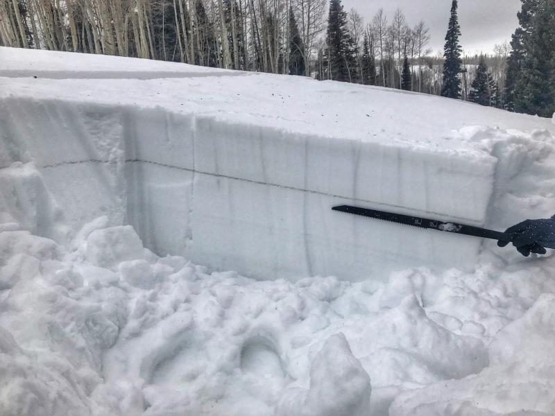
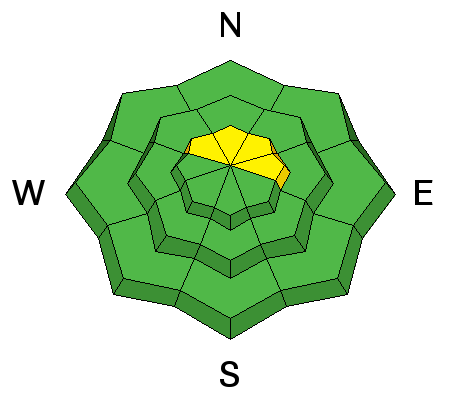
With each loading event we see this dragon come back to life - It's hard to say how much wind or snow (weight) it will take to re-activate this beast. Our lingering persistent slab avalanche problem exists at elevations 8500' and above, on slopes facing northwest through east (with a particular emphasis on north through northeast.) Thinner snowpack areas are particularly suspect. As an outlier, surface hoar formed on the 22nd and buried on the 25th has been noted in the mountains east of Hunstsville and Eden (and in the southern end of the Logan zone) and has yet to be reactive to human weight or snow tests. This is a layer of concern. Any collapsing or cracking in this layering is a red flag. It'll be important to watch this layer and see if additional wind loading may provide additional stress in localized terrain. (Photo Below) This year, I've continued to avoid this terrain all together by keeping my slope angles to 30° and avoiding terrain that's above and adjacent to me. I simply do not trust the snowpack. I am yet to ride anything steep (greater than 30°) that faces the north half of the compass. Maybe, some would call me too conservative (that's okay) I am in it for the long run. Photo: surface hoar we found in Monte Crisco area of Ogden mountains. It's the long gray stripe in the snowpack, about a foot down from the surface.
|
| type | aspect/elevation | characteristics |
|---|

|
|
LIKELIHOOD
 LIKELY
UNLIKELY
SIZE
 LARGE
SMALL
TREND
INCREASING DANGER
SAME
DECREASING DANGER
|
|
description
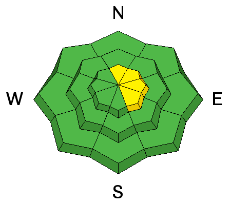
As the strong westerly winds continue across the high elevations it will grab whatever snow is available for transport - depositing the snow on the lee side of ridges and terrain features. It only takes a few inches of snow to create new sensitive wind drifts. Avoid rounded, pillowy snow, especially if it sounds hollow like a drum. |
 |
weather We remain under a northwest flow today and tomorrow. Winds will continue to blow from the west and north with speeds of 20-30 mph gusting into the 30's and 40's across the mid to high elevation terrain. Snow showers will be off and on, with times of riming. Temperatures are expected to cool slightly this afternoon and the rain/snow line will be dropping from 8000' down to 6000' later today. Tonight and tomorrow will be the best chance for snow as a another trough swings by. lets hope for 4" to 8" inches of total snow by Tuesday evening before drying out midweek. |
| general announcements CLICK HERE FOR MORE GENERAL INFO AND FAQ The UAC has new support programs with Outdoor Research and Darn Tough. Support the UAC through your daily shopping. When you shop at Smith's, or online at Outdoor Research, REI, Backcountry.com, Darn Tough, Patagonia, NRS, Amazon, eBay a portion of your purchase will be donated to the FUAC. See our Donate Page for more details on how you can support the UAC when you shop. Benefit the Utah Avalanche Center when you buy or sell on eBay - set the Utah Avalanche Center as a favorite non-profit in your eBay account here and click on eBay gives when you buy or sell. You can choose to have your seller fees donated to the UAC, which doesn't cost you a penny This information does not apply to developed ski areas or highways where avalanche control is normally done. This advisory is from the U.S.D.A. Forest Service, which is solely responsible for its content. This advisory describes general avalanche conditions and local variations always occur. |