25th Annual Black Diamond Fall Fundraising Party
Thursday, September 13; 6:00-10:00 PM; Black Diamond Parking Lot
25th Annual Black Diamond Fall Fundraising Party
Thursday, September 13; 6:00-10:00 PM; Black Diamond Parking Lot
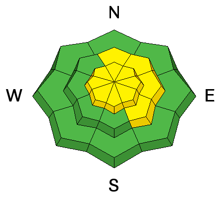
| Advisory: Ogden Area Mountains | Issued by Evelyn Lees for Tuesday - January 23, 2018 - 7:00am |
|---|

|
bottom line The Avalanche Danger is MODERATE on steep, mid and upper elevation slopes facing northerly through easterly. Human triggered avalanches are possible, and large avalanches can be triggered in isolated places. Avoid the steep, north through easterly facing slopes, where it’s most likely to trigger a slab avalanche. Periods of winds have created a MODERATE danger for triggering wind drifts along mid and upper elevation ridgelines, which will become more widespread this afternoon. Both dry and wet loose sluffs are possible on steep slopes. Low angle slopes of all aspects have superb turning and riding in classic Utah powder.
|
 |
special announcement The UAC has new support programs with Outdoor Research and Darn Tough. Support the UAC through your daily shopping. When you shop at Smith's, or online at Outdoor Research, REI, Backcountry.com, Darn Tough, Patagonia, NRS, Amazon, eBay a portion of your purchase will be donated to the FUAC. See our Donate Page for more details on how you can support the UAC when you shop. We have discount lift tickets for Alta, Snowbird, Brighton, Solitude, Snowbasin,and Beaver Mountain. Details and order information here. All proceeds from these go towards paying for avalanche forecasting and education! |
 |
current conditions About a foot of settled powder continues to provide excellent turning and riding conditions on all wind sheltered aspects in the Ogden area backcountry. This morning, under partly to mostly cloudy skies, temperatures are in the teens and the westerly winds are light. Speeds are averaging 5 to 10 mph at the low and mid elevations, and 15 to 20 mph across the highest peak. Yesterday there was a mini wind event, with Mount Ogden averaging 35 mph, gusting to 40 for several hours from the west southwest. |
 |
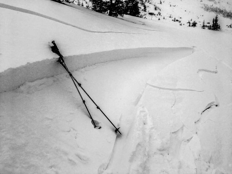
recent activity Slightly stronger winds across Cutler Ridge in the Ogden area mountains quickly whipped up some very sensitive wind drifts, foreshadowing the tomorrow’s conditions. Doug Wewer photo and observation.
|
| type | aspect/elevation | characteristics |
|---|

|
|
LIKELIHOOD
 LIKELY
UNLIKELY
SIZE
 LARGE
SMALL
TREND
 INCREASING DANGER
SAME
DECREASING DANGER
|
|
description
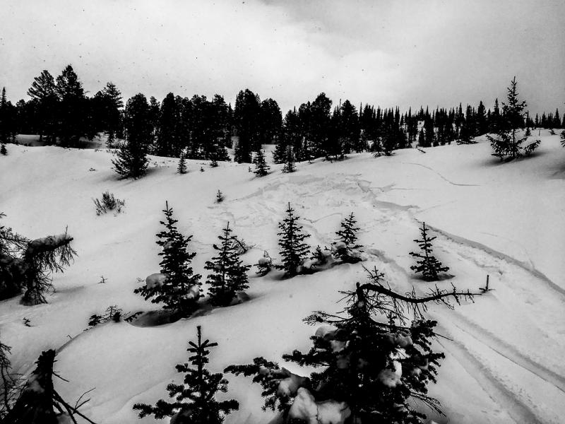
Poor structure – a slab above various layers of weak snow - remains widespread in the snow pack. It is still possible for a person to trigger a slide failing on one of these unpredictable weak, sugary layers, on a steep, shady northwest through easterly facing slope, that would be 1 to 3 feet deep, and up to a couple hundred feet wide. Thinner snowpack areas are particularly suspect – such as rocky rollovers. Weak basal facets have been noted on southwesterly facing slopes, too, in the Salt Lake area mountains. Craig and Andrew went and looked at the Caribou slide, Snake Creek, in the Provo area mountains, Snake Creek, which failed on one of the facet layers. A great visual of Strong snow/weak snow. |
| type | aspect/elevation | characteristics |
|---|

|
|
LIKELIHOOD
LIKELY
UNLIKELY
SIZE
 LARGE
SMALL
TREND
 INCREASING DANGER
SAME
DECREASING DANGER
|
|
description
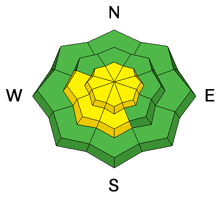
Vast amounts of snow are available for transport, and a mini wind event yesterday on Cutler Ridge, Ben Lomond, quickly whipped up some very sensitive wind drifts, which could be triggered from a distance. A brief overnight increase in wind speeds created new drifts along the higher elevations, and drifts will become even more widespread as wind speeds increase this afternoon and tonight. Heads up: tomorrow the landscape and danger will change with strong winds in the forecast. Cutler ridge wind slab, Doug Wewer photo.
|
| type | aspect/elevation | characteristics |
|---|

|
|
LIKELIHOOD
LIKELY
UNLIKELY
SIZE
 LARGE
SMALL
TREND
INCREASING DANGER
SAME
DECREASING DANGER
|
|
description
Both dry and wet loose sluffs are possible today. Dry loose sluffs: could still be triggered today on very steep slopes of all aspects, and a few may be far running if they have slick sun or wind crusts beneath them. Wet Loose Sluffs: direct sun and warming temperatures this afternoon may dampen the snow surface on south through westerly facing slopes, making it possible to trigger damp sluffs on steep slopes |
 |
weather One more quiet weather day before the winds ramp up tonight and tomorrow, ahead of the next storm on Thursday. Partly cloudy skies this morning will give way to sunny skies this afternoon, with temperatures warming into the upper twenties. Winds should finally settle on a southwesterly direction, and slowly increase, reaching 15 mph averages by afternoon, with gusts in the 20s. The highest ridgelines will reach averages in the 20s, gusting in the 30s. Warm, and increasingly windy tomorrow ahead of Thursday evening’s quick moving storm, which should bring 4 to 7” of new snow |
| general announcements CLICK HERE FOR MORE GENERAL INFO AND FAQ Support the UAC through your daily shopping. When you shop at Smith's, or online at REI, Backcountry.com, Patagonia, NRS, Amazon, eBay a portion of your purchase will be donated to the FUAC. See our Donate Page for more details on how you can support the UAC when you shop. Benefit the Utah Avalanche Center when you buy or sell on eBay - set the Utah Avalanche Center as a favorite non-profit in your eBay account here and click on eBay gives when you buy or sell. You can choose to have your seller fees donated to the UAC, which doesn't cost you a penny. This information does not apply to developed ski areas or highways where avalanche control is normally done. This advisory is from the U.S.D.A. Forest Service, which is solely responsible for its content. This advisory describes general avalanche conditions and local variations always occur. |