25th Annual Black Diamond Fall Fundraising Party
Thursday, September 13; 6:00-10:00 PM; Black Diamond Parking Lot
25th Annual Black Diamond Fall Fundraising Party
Thursday, September 13; 6:00-10:00 PM; Black Diamond Parking Lot
| Advisory: Ogden Area Mountains | Issued by Evelyn Lees for Monday - January 22, 2018 - 7:19am |
|---|


|
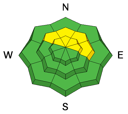
bottom line The Avalanche Danger is MODERATE on steep, mid and upper elevation slopes facing northerly through easterly. Human triggered avalanches are possible, and large, dangerous avalanches can be triggered in isolated places. Use a slope inclinometer and compass to identify and avoid the steep, north through easterly facing slopes, where it’s most likely to trigger an avalanche. Today’s increasing southwesterly winds will also create a MODERATE danger for triggering wind drifts along ridge lines. Low angle slopes of all aspects have superb turning and riding in classic Utah powder.
|
 |
special announcement Episode 3 of the UAC podcast went live last night. We talk with UDOT Avalanche Program Supervisor Bill Nalli on how he and his teams keep the Greatest Snow on Earth from avalanching over the open roads and highways of the state. Find it on our blog site (linked above), iTunes, Stitcher, or wherever you get your podcasts. Do you know the parable of the Scorpion and the Frog? A short piece of fiction from Mineral Fork here. |
 |
current conditions
|
 |
recent activity
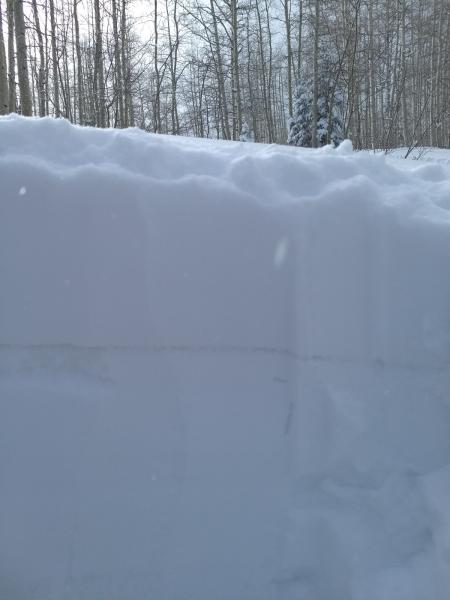
Doug Wewer photo, Ben Lomond
Mike Fogg photo, Monte Cristo, one of the weak facet layers clearly visible
All recent Ogden observations HERE. |
| type | aspect/elevation | characteristics |
|---|

|
|
LIKELIHOOD
 LIKELY
UNLIKELY
SIZE
 LARGE
SMALL
TREND
 INCREASING DANGER
SAME
DECREASING DANGER
|
|
description
The unpredictable, multiple layers of buried faceted snow are a serious problem – they were the weak layer of at least 5 human triggered slides in northern Utah over the weekend - two yesterday and 3 on Saturday - and are the likely culprit of the two weekend fatalities in the west. Slides in Utah are averaging 2 to 3 feet deep, and over 100 feet wide. The layers of weak, sugary facets they are failing on are notoriously tricky, and the snowpack’s response to the weight of a person is erratic and variable. But the location of the slides are not random – the have been triggered on steep, shady slopes facing northwest through easterly, at the mid and upper elevations, and avoiding those slopes is the best way to avoid triggering an avalanche in the backcountry. Avalanches can still be triggered remotely and from below. With the weekend refill of perfect powder, lower angle slopes of all aspects once again have excellent riding and turning conditions. |
| type | aspect/elevation | characteristics |
|---|

|

|
LIKELIHOOD
LIKELY
UNLIKELY
SIZE
 LARGE
SMALL
TREND
INCREASING DANGER
SAME
DECREASING DANGER
|
|
description
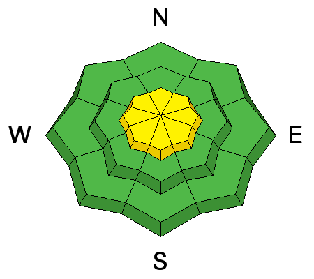
There are enormous amounts of snow available for transport, and even wind speeds as low as 15 mph quickly move low density snow into drifts. Along the ridge lines, snow will be moving today and forming soft drifts. These can be triggered on steep slopes, and will be most widespread on north through easterly facing slopes. The drifts should be mostly confined to right along the ridge lines, but look for drifts anywhere you find the wind blowing |
| type | aspect/elevation | characteristics |
|---|

|
|
LIKELIHOOD
LIKELY
UNLIKELY
SIZE
 LARGE
SMALL
TREND
 INCREASING DANGER
SAME
DECREASING DANGER
|
|
description
ast moving sluffs can be triggered on steep slopes of all aspects, far running where they are on slick underlying sun and wind crusts, entraining all the storm snow in the path below. They tend to break below a person, though can be serious if they pile up deeply in a gully or terrain trap. |
 |
weather As a weak disturbance scoots by to the north, there will be increasing clouds today and a chance for a few snowflakes near the Idaho border. Temperatures will try to crawl out of the icebox, warming into the upper teens to upper 20s. The southwesterly winds will average less than 10 mph at most low and mid elevations, but speeds will increase with elevation. Average speeds of 15 to 25 mph, with gusts to 40, are possible along the high ridge lines by afternoon. Temperatures and wind speeds will increase tomorrow ahead of a fast moving storm, which should bring a shot of snow Thursday night. |
| general announcements CLICK HERE FOR MORE GENERAL INFO AND FAQ Support the UAC through your daily shopping. When you shop at Smith's, or online at REI, Backcountry.com, Patagonia, NRS, Amazon, eBay a portion of your purchase will be donated to the FUAC. See our Donate Page for more details on how you can support the UAC when you shop. Benefit the Utah Avalanche Center when you buy or sell on eBay - set the Utah Avalanche Center as a favorite non-profit in your eBay account here and click on eBay gives when you buy or sell. You can choose to have your seller fees donated to the UAC, which doesn't cost you a penny. This information does not apply to developed ski areas or highways where avalanche control is normally done. This advisory is from the U.S.D.A. Forest Service, which is solely responsible for its content. This advisory describes general avalanche conditions and local variations always occur. |