25th Annual Black Diamond Fall Fundraising Party
Thursday, September 13; 6:00-10:00 PM; Black Diamond Parking Lot
25th Annual Black Diamond Fall Fundraising Party
Thursday, September 13; 6:00-10:00 PM; Black Diamond Parking Lot
| Advisory: Ogden Area Mountains | Issued by Drew Hardesty for Wednesday - December 27, 2017 - 7:22am |
|---|

|
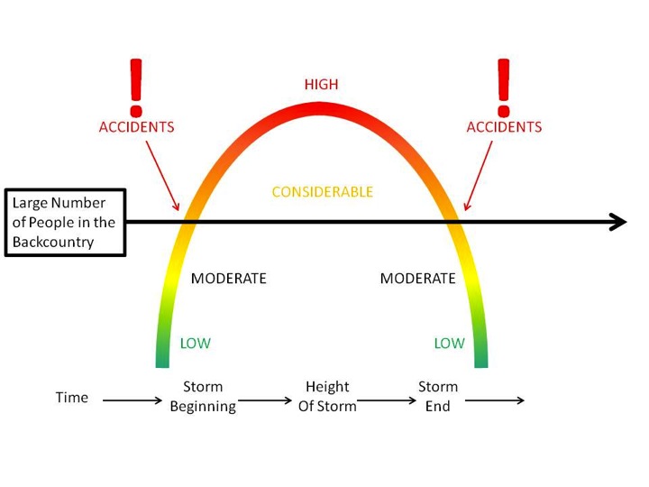
bottom line We have a solid CONSIDERABLE avalanche danger on many slopes in the backcountry. Remember that these 1-2' deep and up to 300' wide avalanches are unmanageable - they can be triggered remotely from a distance and from below. Best to choose low angle slopes not connected to steeper terrain above. I'll be honest here: these are the types of days where we see avalanche accidents.
|
 |
special announcement |
 |
current conditions Skies are partly cloudy with temps in the upper 20s to low 30s. Winds are 20mph from the west southwest. Upper elevation snowpack depths sit at two to almost three feet. Riding conditions are quite good, though a touch thin at the lowest elevations.
|
 |
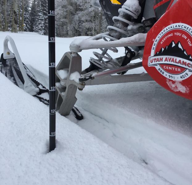
recent activity We have third-hand information of five people caught, carried, and partially buried on Whiskey Hill on Monte Cristo yesterday. No reports of injuries. Bulls Eye clues of cracking and collapsing were everywhere. An avalanche cycle occurred just prior to Christmas Day and many slopes may still yet be triggered by backcountry travelers on and adjacent to steep slopes. Plenty of excellent observations yesterday - 12/26/2017 Observation: Cutler Ridge Ogden region Ben, Kory, Joe 12/26/2017 Avalanche: Whiskey Hill Ogden region Mark Staples third-hand 12/26/2017 Observation: Monte Cristo Peak Ogden region Mark Staples 12/26/2017 Observation: Cutler Ridge Ogden region L. Dunn, J. Steenburgh |
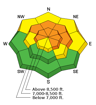
| type | aspect/elevation | characteristics |
|---|

|
|
LIKELIHOOD
 LIKELY
UNLIKELY
SIZE
 LARGE
SMALL
TREND
 INCREASING DANGER
SAME
DECREASING DANGER
|
|
description
Collapsing, cracking and recent avalanches. All bulls eye clues that the snow remains unstable. All observers found very damning snowpit tests that kept them off steep terrain. See Mark explaining what he found at Monte Cristo yesterday. YouTube link |
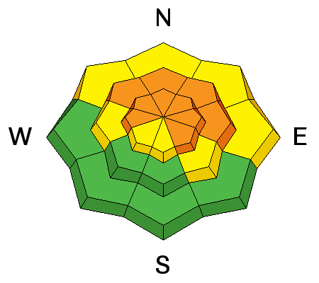
| type | aspect/elevation | characteristics |
|---|

|
|
LIKELIHOOD
 LIKELY
UNLIKELY
SIZE
LARGE
SMALL
TREND
 INCREASING DANGER
SAME
DECREASING DANGER
|
|
description
Gusty west to southwest winds will continue to create sensitive wind drifts in the more open exposed terrain. Once any snow gets moving, it could step down to one of the deeper weak layers, resulting in a much larger avalanche. |
 |
weather We'll see increasing clouds with a disturbance passing by to the north. Westerly winds will increase to 30mph along the high ridglines. Mountain temps will be in the upper 20s to low 30s. Another weak brush by moves through early Friday with another weak system for the weekend. |
| general announcements FOR MORE GENERAL INFORMATION AND FAQ, CLICK HERE Support the UAC through your daily shopping. When you shop at Smith's, or online at REI, Backcountry.com, Patagonia, NRS, Amazon, eBay a portion of your purchase will be donated to the FUAC. See our Donate Page for more details on how you can support the UAC when you shop. Benefit the Utah Avalanche Center when you buy or sell on eBay - set the Utah Avalanche Center as a favorite non-profit in your eBay account here and click on eBay gives when you buy or sell. You can choose to have your seller fees donated to the UAC, which doesn't cost you a penny This information does not apply to developed ski areas or highways where avalanche control is normally done. This advisory is from the U.S.D.A. Forest Service, which is solely responsible for its content. This advisory describes general avalanche conditions and local variations always occur. |