25th Annual Black Diamond Fall Fundraising Party
Thursday, September 13; 6:00-10:00 PM; Black Diamond Parking Lot
25th Annual Black Diamond Fall Fundraising Party
Thursday, September 13; 6:00-10:00 PM; Black Diamond Parking Lot
| Advisory: Ogden Area Mountains | Issued by Evelyn Lees for Friday - December 8, 2017 - 7:14am |
|---|

|
bottom line Today the avalanche danger is MODERATE on northwest through southeast facing slopes with the lingering possibility of triggering a small wind slab. On most other slopes the avalanche danger is LOW. Choose low angle slopes for the best and safest turning conditions. With limited terrain available for riding (low tide as some call it), take the time to practice with your rescue gear if you get out.
|
 |
special announcement Snowbasin is open! They have a few runs open and are working hard to add more. Get important updates from the UAC via text message directly to your phone. Its very simple - dial 40404 and send this message "Follow uacwasatch". Looking for a great stocking stuffer for Christmas? Discount lift tickets for Alta, Snowbird, Brighton, Solitude, Deer Valley, Snowbasin,and Beaver Mountain are now available, donated by the resorts to benefit the Utah Avalanche Center. Details and order information here. These make a great holiday gift and all proceeds go towards paying for avalanche forecasting and education! Please abide by the uphill travel policies of the ski resorts. Info here. |
 |
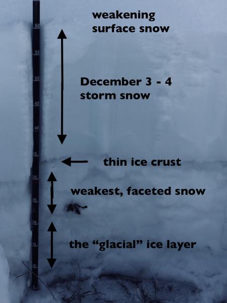
current conditions Temperatures this morning are in the twenties, with the low elevations and drainage bottoms still clinging to the teens. Winds have shifted to the northwest, and are generally averaging less than 10 mph. The exception is Mt Ogden, of course, where speeds of 45 mph, gusting to 50 mph, occurred early this morning. Speeds are on the decrease though. The storm from Sunday/Monday delivered 8-14", with up to 6" at the trail heads. While this was a huge improvement, conditions overall still remain very thin. The best turning conditions right now are at the highest elevations, on low angle slopes that are grassy or smooth underneath. But access continues to be difficult, and you will hit rocks and stumps. If you are on a sled, it'd be wise to stick to the roads and not chance banging up your machine. The pit below is from Wednesday, on an 8800' NNE facing slope. Read the full observation here.
|
 |
recent activity No new avalanches reported from the Ogden area mountains. |
| type | aspect/elevation | characteristics |
|---|

|
|
LIKELIHOOD
 LIKELY
UNLIKELY
SIZE
 LARGE
SMALL
TREND
 INCREASING DANGER
SAME
DECREASING DANGER
|
|
description
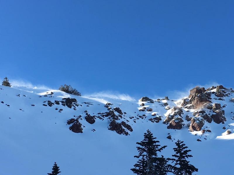
Despite getting a decent shot of snow early this week, conditions are generally pre-season and thin. Your greatest concern will be hitting rocks while trying to make turns or, perhaps, falling. If you do find your way to higher elevations, you'll find a fairly stable snowpack of crusts, facets, and quickly faceting new snow. The winds have been moving snow along the ridge lines so there is a small possibility of triggering an isolated wind slab at the highest elevations. The new wind drift would be the slab, sitting on the weak layer of faceted snow. These could sound hollow and be cracky. Stay off of steep, wind-drifted slopes to avoid this issue. Overall, the snow is mostly stable but for small pockets of lingering wind slabs and fast moving sluffs in the low density snow in steep terrain. Below is a generic photo of a shallow, cracky wind deposit.
|
 |
weather Today’s weather will be similar to yesterday’s…and tomorrow’s…and the day after…and… The high pressure over Utah isn’t budging, so sunny skies and steadily warming temperatures through the weekend. Highs today at 8,000' will be in the upper 30s, with the overnight low dipping into the teens and low 20s. The northerly winds should decrease through out the day, becoming light by evening. A warming trend through the weekend will send the high temperatures into the low 40s. |
general announcements
|