25th Annual Black Diamond Fall Fundraising Party
Thursday, September 13; 6:00-10:00 PM; Black Diamond Parking Lot
25th Annual Black Diamond Fall Fundraising Party
Thursday, September 13; 6:00-10:00 PM; Black Diamond Parking Lot
| Advisory: Ogden Area Mountains | Issued by Paige Pagnucco for Friday - March 3, 2017 - 6:45am |
|---|


|
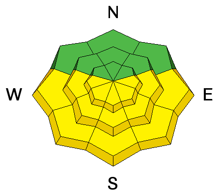
bottom line The avalanche danger will again rise to the high end of MODERATE on all steep sunlit slopes with daytime warming. The steep east to south to west facing terrain is to be avoided by the time it becomes damp and unstable, usually in the mid-morning to mid-afternoon hours. Pockets of MODERATE exist for lingering wind slabs in steep exposed alpine terrain. Cornices are still gargantuan and unruly - take particular care along and beneath cornice-littered ridgelines.
|
 |
special announcement New guest blog by Tom Diegel - The Little Things (that might keep you alive) - Part I |
 |
current conditions A fine spring day is in the making - skies are clear, mountain temperatures are in the low 20's F, and southwesterly winds are blowing 10 - 15 mph, except for Ogden Peak which is seeing gusts into the low 30's. The sun did a bit of damage yesterday as temps rose and dampened the snow on southeast through west facing slopes. You'll likely find crusts of varying thickness on these aspects this morning. Wind has also damaged the surface snow in exposed areas. Your best bet for finding soft, settled, cold powder snow is on north facing sheltered terrain at the mid and upper elevations. Check out an observation by Kory Davis from Thursday. |
 |
recent activity Recent control work results include small stubborn wind slabs on N and NE aspects at higher elevations as well as somewhat touchy cornices. In general, observers are noting good overall stability. |
| type | aspect/elevation | characteristics |
|---|

|
|
LIKELIHOOD
 LIKELY
UNLIKELY
SIZE
 LARGE
SMALL
TREND
 INCREASING DANGER
SAME
DECREASING DANGER
|
|
description
With warm temperatures forecast today, direct sun and warming will dampen and loosen the snow on steep sunlit aspects. Rollerballs and natural wet sluffs are key indicators that the snow is becoming saturated and unstable. When the snow gets gloppy, it's time to move out of the sun and into the shade to avoid wet avalanches that could easily run on the slick crust underneath. Know that avoidance of wet avalanche issues come down to place and time. For example - enjoy the east facing terrain in the early morning and then move to other, cooler aspects before they heat up. As with most things in life, timing is everything. |
| type | aspect/elevation | characteristics |
|---|

|
|
LIKELIHOOD
 LIKELY
UNLIKELY
SIZE
LARGE
SMALL
TREND
 INCREASING DANGER
SAME
DECREASING DANGER
|
|
description
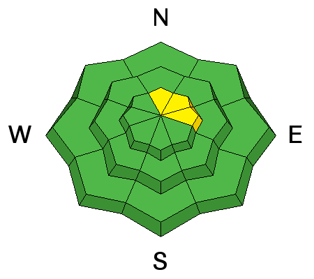
Lingering, isolated pockets of wind slab may be still be triggered on steep slopes in high elevation terrain. These pockets are predominantly found on north through east facing slopes. With continued gusty winds in exposed terrain, look for and avoid fresh wind drifts, though I expect new development to be minimal. |
| type | aspect/elevation | characteristics |
|---|

|
|
LIKELIHOOD
LIKELY
UNLIKELY
SIZE
 LARGE
SMALL
TREND
INCREASING DANGER
SAME
DECREASING DANGER
|
|
description
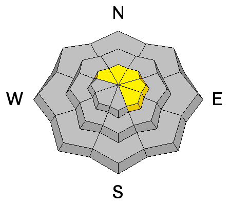
Cornices are enormous. They may break off on approach and break back well beyond the apex of the ridgeline. Longtime observer Brian Smith in Ogden said it best - "it is difficult to tell where the earth ends and the snow begins." Avoid being on or beneath these gigantic whales of snow. |
 |
weather In the Ogden area mountains today we'll have mostly sunny skies, moderate southwesterly winds, and daytime highs reaching to near 45°F at 8500'. The warming trend will continue into the weekend with the next storm system slated for later Sunday into Monday. |
general announcements
|


