25th Annual Black Diamond Fall Fundraising Party
Thursday, September 13; 6:00-10:00 PM; Black Diamond Parking Lot
25th Annual Black Diamond Fall Fundraising Party
Thursday, September 13; 6:00-10:00 PM; Black Diamond Parking Lot
| Advisory: Ogden Area Mountains | Issued by Paige Pagnucco for Friday - January 27, 2017 - 6:23am |
|---|


|
bottom line The avalanche danger today is MODERATE. Evaluate the snow and terrain carefully as human triggered avalanches are possible. Watch for avalanches on low elevation steep slopes especially near gullies, creeks and terrain traps where even a small avalanche can create a deep debris pile.
|
 |
special announcement Do you buy groceries at Smiths? Register your Smith’s rewards card with their Community Rewards program, and they will donate to the Utah Avalanche Center whenever you make a purchase. It's easy, only takes a minute, and doesn't cost you anything. Details |
 |
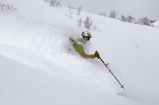
current conditions It is quite chilly this morning with temperatures at 8000' in the single digits and, with light northerly winds, the wind chill is in the negative teens. A few inches of light snow fell yesterday in some areas as the unsettled back end of the storm finally moved out of Utah. Observers are reporting top notch powder riding conditions on settled storm snow covered with 6-12" of lighter density snow. The task today is keeping your slope angles on the conservative side.
An Ogden observer found excellent turning conditions yesterday. (pc:M. Henderson) |
 |
recent activity There have been many slides reported in the Ogden area mountains since the beginning of the storm that dropped about 50" of snow or 2.5" - 3.5" of snow water equivalent. Roadside paths to both Powder Mountain and Snowbasin slid during the peak of the storm. Natural avalanches from Monday were observed all around the Cutler Ridge and Cutler Creek area on Tuesday. Wednesday near Lewis Peak, a skier reported cracks shooting 10-20 feet in front of his ski tips. Also, a skier in the backcountry near Snowbasin reported fast sluffs in the new snow running up to 600 feet. There have also been reports of soft slabs running on top of Monday's now buried windslabs. Wednesday, a skier was caught and carried in a slide on Mt Aire which is just west of Lambs Canyon along I-80. Although this slide happened closer to SLC, it is relevant to the Ogden area as the buried surface hoar was the weak layer. Fortunately this skier was not buried or injured. He was the second person to descend the slope. UAC staff looked at this slide and found widespread buried surface hoar about 2 feet deep on W, N and E aspects. A report is available HERE. |
| type | aspect/elevation | characteristics |
|---|

|
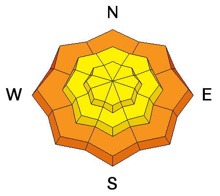
|
LIKELIHOOD
 LIKELY
UNLIKELY
SIZE
 LARGE
SMALL
TREND
 INCREASING DANGER
SAME
DECREASING DANGER
|
|
description
Recent persistent slab avalanches have been triggered on a layer of buried surface hoar or on a layer of small, faceted crystals buried 2-4 feet deep. This layer is widespread in the Ogden area mountains though there are some places where it was destroyed prior to the storm. The buried surface hoar is most dangerous where it was sheltered from the wind and buried intact. It might catch you off guard as you descend into sheltered, lower and possibly some mid-elevation slopes or gullies. Though observers near Ben Lomond noted its presence yesterday and were unable to get propagation while performing stabiity tests, this type of weak layer is deceptive and takes a while to strengthen. Because this weak layer can be coy, your best bet for finding it is to dig about 4 feet deep, perform stabilty tests like the ECT, and make sure it doesn't exist. Buried surface hoar does not behave like a typical weak layer so a lack of cracking, collapsing, or other obvious signs of instability does not mean slopes are stable. Tracks from other people are also not a guarantee of stability. If you are not interested in digging then the easy solution is to avoid being on, connected to, or underneath slopes steeper than 30 degrees.
Left: Observed buried surface hoar near Rodeo Ridge was unreactive to stability tests yesterday. (pc:M. Henderson) Right: One of numerous avalanches failing on buried surface hoar or small facets on Monday in the Cutler Ridge area. (pc: B. Brandt) |
| type | aspect/elevation | characteristics |
|---|

|
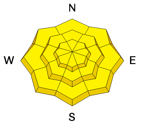
|
LIKELIHOOD
 LIKELY
UNLIKELY
SIZE
LARGE
SMALL
TREND
 INCREASING DANGER
SAME
DECREASING DANGER
|
|
description
Though we are observing an increase in overall stability, we are also in the phase where human triggered avalanches are still very possible. The snowpack is continuing to adjust to the massive amount of snow received in the last week. The storm snow is settling and gaining strength but there are many places it has not completely stabilized. Watch for signs of instability like cracking and collapsing. Check out Brian Smith's test slope video from yesterday displaying sensitivity in the new snow at low elevations. It might also be possible to trigger loose snow sluffs in steep terrain at all elevations. These can run far and entrain deeper snow as they descend. Inventory consequences when choosing terrain. Cornices that built up during the storm are also suspect and should be avoided. Winds are blowing a little stronger on the ridge tops and, with lots of new snow to transport, wind slabs could build during the day. Avoid areas of freshly wind drifted snow on steep slopes. With mostly sunny skies forecast today, you might need to keep an eye out for wet activity, specifically on southerly facing slopes. Avoid steep slopes when the snow starts to feel moist from direct sun exposure though forecast cold temperatures and the building inversion should keep warming mostly in check. |
 |
weather Powder preservation weather is on tap for today - cold temps forecast to reach only the mid teens and a cold northwest breeze. Enjoy it now as slowly warming temps and sunny skies are moving in starting tomorrow. Inversions will be strong in the valleys as mountain weather will remain benign until possibly mid to late next week. |
general announcements
|