25th Annual Black Diamond Fall Fundraising Party
Thursday, September 13; 6:00-10:00 PM; Black Diamond Parking Lot
25th Annual Black Diamond Fall Fundraising Party
Thursday, September 13; 6:00-10:00 PM; Black Diamond Parking Lot
| Advisory: Ogden Area Mountains | Issued by Evelyn Lees for Wednesday - January 25, 2017 - 7:15am |
|---|

|
bottom line The avalanche danger is CONSIDERABLE on all steep slopes in the Ogden area mountains, including low elevation slopes. Avalanches 2 to 4 feet deep can be triggered, both on slopes and remotely from a distance. Careful snow pack evaluation, cautious route finding and conservative decision making are essential for the backcoutnry traveler in avalanche terrain today. There is unusually weak snow at the lower elevations – avalanches can be triggered below 7000’. Avoid steep slopes and terrain traps such as gullies, creek beds, and trails and roads below steep banks where even a small slide can pile snow up deeply.
|
 |
special announcement If you sign up for AmazonSmile and designate the Utah Avalanche Center as your favorite charity, they will donate a portion of everything you spend to the UAC. I doesn't cost you a penny and we'd really appreciate the help. TONIGHT!! Drew will be hosting the Fireside Chat at the Black Diamond store this Wednesday at 7pm. Topic: Expert Intuition in High Risk - Low Frequency Events. Best if you have a decent grasp of the different avalanche problems, but all are welcome to this informal, low key, picnic - style gathering. |
 |
current conditions It’s feeling like winter out there, with upper elevation temperatures dancing around ten degrees this morning. Very low-density snow is falling from the sky, with 6 to 8” of snow reported in the Ogden area mountains (once again the epicenter of snowfall, double what many other area are reporting), capping off the past week’s storm totals of 3 to 6 feet. The westerly winds are just a breeze – averaging less than 10 mph at most stations, though some may be slowed due to riming. I would guess upper elevation ridge lines could be averaging to 20 mph at times. |
 |
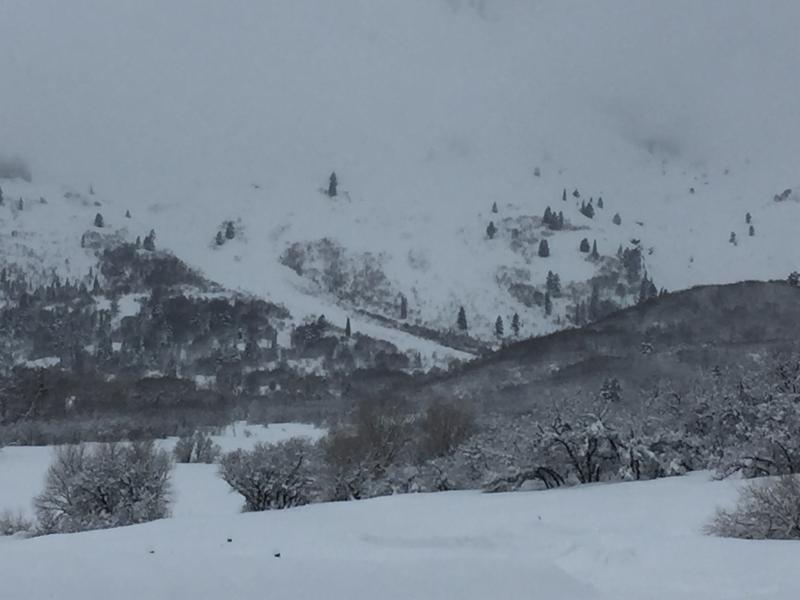
recent activity In the Ogden area mountains, natural avalanches ran during storm, at all elevations and all aspects. Low elevation slides were up to 4' deep, and there were long runs to 2500' vertical in the backcountry. The resorts continued to release new snow snow slides yesterday. And finally, we got a 4 am report from upper Little Cottonwood of sensitive long running sluffs in the newest snow - I would expect similar sensitivity in the new snow in the Ogden area mountains.
Bill Brandt took these photos yesterday of natural avalanches that occurred during the storm.
|
| type | aspect/elevation | characteristics |
|---|

|

|
LIKELIHOOD
 LIKELY
UNLIKELY
SIZE
 LARGE
SMALL
TREND
 INCREASING DANGER
SAME
DECREASING DANGER
|
|
description
STORM SNOW SLABS: There are layers of low density snow from early in the storm that were still acting as a weak layer in yesterday’s avalanches. These layers will be less sensitive today, but you can still trigger new snow soft slabs on steep slopes of all aspects and elevations. They will be most likely on a slope that was wind drifted during the storm. CORNICES: cornices always seem to break back further than expected, even onto what looks like “flat” terrain along the ridge lines. LOOSE SNOW SLUFFS: Expect sensitive, long running sluffs in the newest snow that fell overnight and is falling this morning. |
| type | aspect/elevation | characteristics |
|---|

|
|
LIKELIHOOD
LIKELY
UNLIKELY
SIZE
 LARGE
SMALL
TREND
 INCREASING DANGER
SAME
DECREASING DANGER
|
|
description
Before the storm started last week, the old snow surfaces included small grained facets on some slopes – most widespread in the Ogden area mountains. Mark traveled in the Bountiful Peak area yesterday, and was able to easily find this faceted weak layer about 3 feet down. This weak layer will be much slower to strengthen. Avalanches breaking on facets are tricky and more dangerous. They can be triggered remotely from a distance or from low angle slopes below. When the facets become more stubborn over time, then avalanches can break above you when you’re mid slope. These faceted weak layers are most widespread in wind sheltered, shady mid and low elevation terrain. There are also a variety of buried thin and thick crusts, some with associated facets, on southeast through west facing slopes and at the lower elevations. These crust/facet layers can act as weak layers or bed surfaces, and distribution is complicated. |
 |
weather A weak storm will bring periods of snow to the mountains today, adding a few more inches of the lightest 3% density fluff. Temperatures will only warm to 10 degrees along the high ridge lines, and the westerly winds should remain light all day – averaging 5 to 15 mph, with only the highest peaks gusting above 20 mph. Occasional light snow and cold temperatures will continue tonight and Thursday before high pressure moves in to dominate the weather starting Friday. |
general announcements
|