25th Annual Black Diamond Fall Fundraising Party
Thursday, September 13; 6:00-10:00 PM; Black Diamond Parking Lot
25th Annual Black Diamond Fall Fundraising Party
Thursday, September 13; 6:00-10:00 PM; Black Diamond Parking Lot
| Advisory: Ogden Area Mountains | Issued by Drew Hardesty for Sunday - January 15, 2017 - 7:22am |
|---|

|
bottom line The danger will rise to MODERATE on the steep sunlit slopes today with daytime warming. A low-probability high consequence Moderate danger exists at the mid to low elevations for triggering a potentially unsurvivable 2-4' deep avalanche below 7500' in elevation. Triggering a stabilizing storm slab is unlikely but not impossible with heavy loads (cornices, sluffs, a falling skier). Use extreme caution traveling along the heavily corniced ridgelines and continue to use safe travel protocol: make a plan, one at a time in steep terrain, get out of the way at the bottom. Sluffing in the cold dry snow is increasingly possible in steep northerly terrain. Please communicate with other parties and try to avoid being above or beneath others in our very crowded Wasatch Range.
|
 |
special announcement New blog post - Shame and the Social Contract |
 |
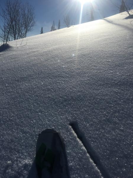
current conditions Skies are clear in the mountains. Winds are light from the east. Temps are in the low to mid 20s. Surface Hoar abounds (see Wewer pic below). Clear skies, light winds, and high RH (relative humidity) yield yet again another crop of surface hoar. Recall that surface hoar is the winter-time equivalent of dew, but it has the mark of Cain, if the two are related. Fun to ski and ride through and beautiful as crystal, but dangerous and unpredictable if buried by another storm. Commonly, the fragile "feathers" decay or are destroyed by sun and wind in the pre-frontal environment, but worth mapping out along the topography prior to the next weather events. Riding conditions are 4 stars out of 5. Sunny aspects have fewer stars with a breakable melt-freeze crust this morning. Doug Wewer has an excellent report from Ben Lomond from yesterday; Bill Hunt's thoughts on the Snowbasin periphery are here.
Rough storm totals (read Snow/SWE - Snow-Water-Equivalent). See above for the years SWE % of normal. Since last Saturday night ---------Since New Years----------------------Total snow depths Upper LCC: 37"/4.48"................. 72"/6.90".................... Total snow depths are 80-90" Upper BCC: 46"/4.78"............... 103"/8.46".................... Total snow depths are 80-95" PC ridgeline: 41"/4.70"............... 80"/7.4" ..................... Total snow depths are 75-85" Ogden 27"/2.5"-62"/7.95"............ 46"/3.71-83"/10.23..............Total snow depths are 80-100" Provo 35"/3.19" ....................... 67"/5.79" ................. ... Total snow depths are 80-120" |
 |
recent activity A widespread natural avalanche cycle occurred overnight Wednesday-Thursday in the Ogden zone. Numerous persistent slab avalanches up to 5' deep released on low and mid-elevation slopes. Many of these were in the Cutler Ridge area while one was reported in the backcountry near Snowbasin. Snowfall intensified overnight which likely overloaded the persistent weak layers present just above the mid-December rain crust and caused them to fail. More recently, a large cornice fall high along the Ogden skyline triggered a storm slab below with debris reportedly enough to bury a person. This on a very steep northeast facing slope above 9000'. Avalanche activity during the big storm from other zones: Uintas - Two snowboarders survive a large avalanche on Wednesday - see report and video here. Logan - Widespread natural avalanche cycle in the Wellsville Mountain range - photos of massive Mitton Peak avalanche here. |
| type | aspect/elevation | characteristics |
|---|

|

|
LIKELIHOOD
 LIKELY
UNLIKELY
SIZE
 LARGE
SMALL
TREND
 INCREASING DANGER
SAME
DECREASING DANGER
|
|
description
Persistent weak layers have been reactivated by the sheer volume and added water weight of the recent new snow. The tipping point seemed to occur Wednesday night when numerous destructive avalanches up to 5' deep released naturally on low and mid elevation, north through southeast facing slopes. They consistently failed on faceted weak snow just above the mid-December rain crust. These types of avalanches are not to be trifled with as they are low probability but high consequence - they can lure you way out onto them before releasing. Taking a ride will lead to a bad outcome. You can easily avoid this problem by sticking to slopes less than 30 degrees and giving the snowpack time to adjust to the new load. The storm and wind slab instabilities are rapidly healing but may still be triggered with heavy loads, such as cornice fall or another avalanche cascading down from above. Thinner snowpack areas such as Mt Aire and Lambs have a persistent slab issue with a Moderate danger at the mid to low elevations; this terrain should be approached with caution. It's recommended to conduct a few snow tests to gauge the instability with this structure. More info is needed from this area. Hot Tip: These storm slab avalanches are unlikely but not impossible. Stack the odds in your favor and choose terrain that doesn't amplify the risk of traumatic injury (debris running through a forested area) or deep burial (steep walled creekbeds or gullies). |
| type | aspect/elevation | characteristics |
|---|---|---|

|
|
LIKELIHOOD
 LIKELY
UNLIKELY
SIZE
 LARGE
SMALL
TREND
 INCREASING DANGER
SAME
DECREASING DANGER
|
description
|
| type | aspect/elevation | characteristics |
|---|

|
|
LIKELIHOOD
 LIKELY
UNLIKELY
SIZE
LARGE
SMALL
TREND
INCREASING DANGER
SAME
DECREASING DANGER
|
|
description
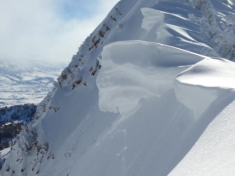
Enormous cornices litter the mid and upper elevation ridgelines and will break back well past the apex of the ridgeline. Give these monsters a very wide berth. Falling over with a breaking cornice may result in significant traumatic injury (at best) and/or provide for a sufficient trigger for an avalanche below. (Bill Hunt photo below). Hot Tip: Give these monsters a very wide berth.
|
 |
weather Short term -Time to add sunscreen and a visor to your pack. The weather for the rest of the long weekend looks just about perfect - cold nights, calm winds and sunny, mild days. Temperatures in the mountains are forecast to reach the mid to high 20's F today. Next week - High pressure aloft will settle over the Ogden zone for the first half of the week, followed by a return to an active weather pattern late in the week. |
general announcements
|