25th Annual Black Diamond Fall Fundraising Party
Thursday, September 13; 6:00-10:00 PM; Black Diamond Parking Lot
25th Annual Black Diamond Fall Fundraising Party
Thursday, September 13; 6:00-10:00 PM; Black Diamond Parking Lot
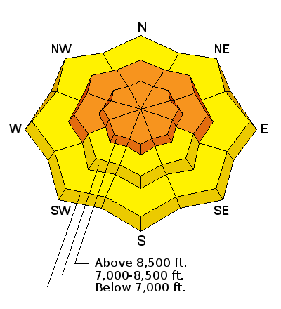
| Advisory: Ogden Area Mountains | Issued by Paige Pagnucco for Saturday - December 24, 2016 - 5:21am |
|---|

|
bottom line The avalanche danger is rising to CONSIDERABLE today. Falling snow and strong winds will create dangerous avalanche conditions as a winter storm moves through the area. Careful snowpack evaluation, cautious route-finding, and conservative decision making are essential today in the backcountry. Pay careful attention to rapidly changing avalanche conditions due to wind loading and heavy snowfall.
|
 |
special announcement Discount lift tickets for Beaver Mountain, Snowbasin, Powder Mountain, and the Central Wasatch resorts are now available, donated by the resorts to benefit the Utah Avalanche Center. Details and order information here. These make a great holiday gift and all proceeds go towards paying for avalanche forecasting and education! |
 |
current conditions Temperatures in the mountains this morning are in the low to mid 20's F. Winds are blowing 20+ mph with gusts on the ridges around 35-40 mph from the southeast. Ben Lomond received about 6" of new snow overnight. Riding conditions will improve today with expected snowfall. The mountains should get enough snow from this storm to cover up the inconsistent existing snow surface. The best conditions will be in low angle, sheltered terrain. We appreciate getting your observations. If you see or trigger an avalanche or just have a general observation, please submit it here. |
 |
recent activity No recent reports of avalanches. |
| type | aspect/elevation | characteristics |
|---|

|

|
LIKELIHOOD
 LIKELY
UNLIKELY
SIZE
 LARGE
SMALL
TREND
 INCREASING DANGER
SAME
DECREASING DANGER
|
|
description
Ridgetop winds were very strong overnight and are expected to continue throughout much of the day. Combined with the forecasted snowfall, wind slabs will be a major concern in high elevation and/or exposed terrain. The new snow is landing on a variety of surfaces so it'll be best to avoid steep, wind loaded slopes. Watch for newly-formed wind drifts near terrain features such as sub-ridges and outcroppings as well as cross loading at mid elevations and well off of ridgelines. (Note: winds are from the east southeast, an uncommon direction for our area. Pay particular attention to wind loading on west and northwest facing slopes.) Re-evaluate your route if you encounter obvious signs of instability like cracking or collapsing. |
| type | aspect/elevation | characteristics |
|---|

|
|
LIKELIHOOD
LIKELY
UNLIKELY
SIZE
LARGE
SMALL
TREND
INCREASING DANGER
SAME
DECREASING DANGER
|
|
description
Snowfall is expected to continue throughout the day with periods of increased intensity. There will be areas where the new snow will bond poorly to the old snow surface. Avoid steep slopes and watch for obvious signs of instability such as cracking or collapsing. |
| type | aspect/elevation | characteristics |
|---|

|
|
LIKELIHOOD
 LIKELY
UNLIKELY
SIZE
 LARGE
SMALL
TREND
INCREASING DANGER
SAME
DECREASING DANGER
|
|
description
Buried faceted layers create persistent slab avalanches so this type of avalanche problem can last for a long time. It's worth getting the saw and shovel out and performing stability tests in different areas to check for these weaknesses. There's a very slim chance of triggering a very large avalanche like one that happened on Monday in Little Cottonwood Canyon in the Birthday Chutes. A similar avalanche that occurred naturally last weekend was spotted by an observer near Bountiful Peak. These deep slab avalanches are rare but deadly events. They can occur high elevations where snow existed in early and mid November. |
 |
weather The National Weather Service has issued a Winter Storm Warning lasting through early Monday morning. Some areas in the Ogden mountains could receive up to 1-2 feet of snow. The period of heaviest snow is expected to occur from this evening into tomorrow morning. Temperatures will drop considerably tomorrow as colder air moves into the region. Happy Holidays! |
| general announcements Remember your information can save lives. If you see anything we should know about, please help us out by submitting snow and avalanche conditions. You can also call us at 801-524-5304, email by clicking HERE, or include #utavy in your tweet or Instagram. To get help in an emergency (to request a rescue) in the Wasatch, call 911. Be prepared to give your GPS coordinates or the run name. Dispatchers have a copy of the Wasatch Backcountry Ski map. Backcountry Emergencies. It outlines your step-by-step method in the event of a winter backcountry incident. If you trigger an avalanche in the backcountry, but no one is hurt and you do not need assistance, please notify the nearest ski area dispatch to avoid a needless response by rescue teams. Thanks.
EMAIL ADVISORY If you would like to get the daily advisory by email you will need to subscribe here. TWITTER Updates for your mobile phone - DETAILS Utah Avalanche Center mobile app - Get your advisory on your iPhone along with great navigation and rescue tools. Lost or Found something in the backcountry? - http://nolofo.com/ To those skinning uphill at resorts: it is critical to know the resort policy on uphill travel. You can see the uphill travel policy for each resort here. Benefit the Utah Avalanche Center when you shop from Backcountry.com or REI: Click this link for Backcountry.com or this link to REI, shop, and they will donate a percent of your purchase price to the UAC. Both offer free shipping (with some conditions) so this costs you nothing! Benefit the Utah Avalanche Center when you buy or sell on ebay - set the Utah Avalanche Center as a favorite non-profit in your ebay account here and click on ebay gives when you buy or sell. You can choose to have your seller fees donated to the UAC, which doesn't cost you a penny.
|


 This information does not apply to developed ski areas or highways where avalanche control is normally done. This advisory is from the U.S.D.A. Forest Service, which is solely responsible for its content. This advisory describes general avalanche conditions and local variations always exist.