25th Annual Black Diamond Fall Fundraising Party
Thursday, September 13; 6:00-10:00 PM; Black Diamond Parking Lot
25th Annual Black Diamond Fall Fundraising Party
Thursday, September 13; 6:00-10:00 PM; Black Diamond Parking Lot
| Advisory: Ogden Area Mountains | Issued by Trent Meisenheimer for Sunday - December 18, 2016 - 6:59am |
|---|

|
bottom line There is an overall MODERATE Avalanche Danger on all steep mid and upper elevation slopes, where human triggered avalanches are possible. Wind slabs have potential to step down into deeper weaker layers, creating a much larger and dangerous avalanche. Avoid all steep, shallow, rocky wind drifted terrain.
|
 |
special announcement Wondering about canyon closures? Click just below the red UDOT square on our home page for current info, or follow @udotavy on instagram. Discount lift tickets for Alta, Snowbird, Brighton, Solitude, Sundance, Snowbasin, Powder Mountain, and Beaver Mountain are now available, donated by the resorts to benefit the Utah Avalanche Center. Details and order information here. These make a great holiday gift and all proceeds go towards paying for avalanche forecasting and education! |
 |
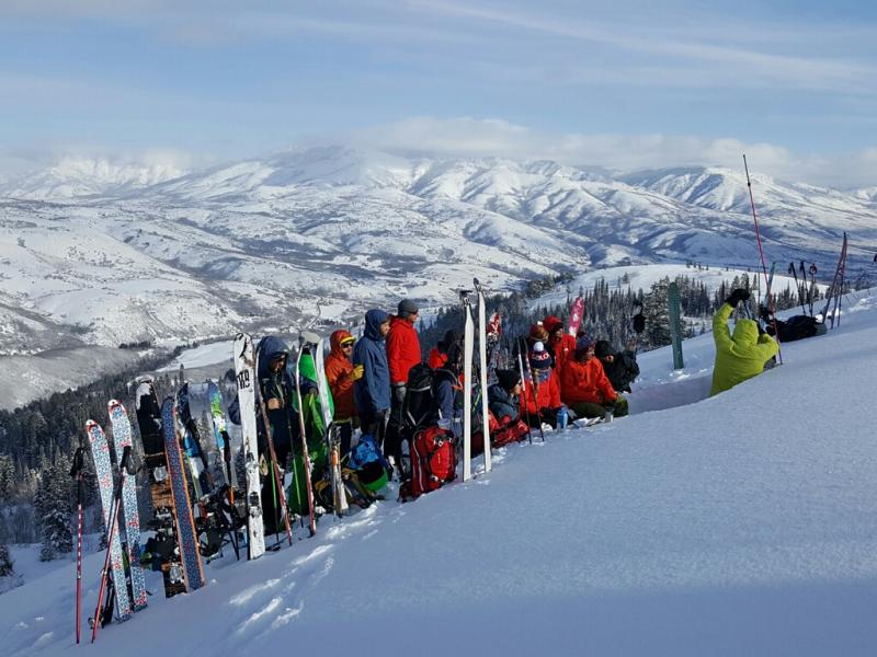
current conditions Burrrrr, it's cold this morning.... Under clear and sunny skies, most trailheads are in the negative single digits, and upper elevation temperatures are hovering around -5 degrees fahrenheit. The hurricane force winds finally relaxed yesterday and the upper elevation weather stations this morning are recording wind speeds of 10-15 mph with gusts into the 20's from the west northwest. Five star turning and riding conditions will be easily found today. All upper elevation aspects hold cold dry powder snow. It was a great day yesterday in Ogden to learn about avalanches and enjoy the white backdrop. Photo: Mike H
|
 |
recent activity No avalanche activity was reported from the backcountry yesterday. However, avalanche reduction crews in Little Cottonwood Canyon had a very deep avalanche release in un-compacted steep, rocky, north facing terrain, above 10,500 feet. The avalanche was 5-8 feet deep 250 feet wide running 900 vertical. Many other reduction teams had results of wind slabs breaking just off ridge lines that were 1-2 feet deep and up to 100 feet wide - deep enough to bury a person. UDOT triggered a sizable avalanche on south facing Mt. Superior that ran full track crossing the closed highway. |
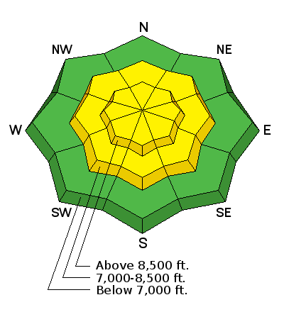
| type | aspect/elevation | characteristics |
|---|

|
|
LIKELIHOOD
 LIKELY
UNLIKELY
SIZE
 LARGE
SMALL
TREND
 INCREASING DANGER
SAME
DECREASING DANGER
|
|
description
The previous storm had ferocious winds and heavy snowfall. This created very deep wind drifts along the mid and upper elevation ridgelines, subridges and midslope break overs. These wind drifts will be easy to spot as they often look rounded and pillowy. Most of these wind slabs will be very stiff and unreactive today, however, if you trigger a sizable wind slab it will likely break 1-2 feet deep and up to a 100 feet wide. It also has the possibility to step down into deeper weaker layers and trigger a much larger unmanageable avalanche. My strategy would to be patient and avoid any steep wind drifted terrain for at least another day. |
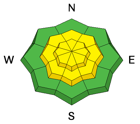
| type | aspect/elevation | characteristics |
|---|

|

|
LIKELIHOOD
 LIKELY
UNLIKELY
SIZE
 LARGE
SMALL
TREND
INCREASING DANGER
SAME
DECREASING DANGER
|
|
description
Do people die when it's a MODERATE avalanche danger? YES. Would I be surprised to hear about someone getting caught in an avalanche today? NO. The snowpack received a huge wallop of wind and heavy snow from the past storm. To make matters complicated, we have weak layers buried in the snowpack. Check out a great observation from Mike H. The weaker layers midpack and the faceted snow at the ground are starting to gain strength. Many slopes will be good to go today, but the chance of triggering a large, dangerous, avalanche is a possibility as well. Especially, in steep, rocky, northerly facing terrain that has recent drifts of wind blown snow. This is not the type of avalanche you want to mess with. Be patient - let the big lines sit for at least another day and let the snowpack gain a little more strength. There remains five star powder on many 30 degree slopes where you could have a blast all day and not even worry about avalanches. Drew Hardesty wrote an amazing blog in 2013 that describes exactly what I am trying to convey today. By the North American Avalanche Danger Scale we do not fit the definition of a CONSIDERABLE danger. We fall into a MODERATE category. However, there is a big difference between a moderate danger for a soft slab avalanche and moderate danger for a hard slab avalanche. A quick excerpt from his blog - "Imagine if you were offered $10 million dollars to play Russian Roulette. Would it change anything if I told you ahead of time how many rounds were in the chamber? Would you make your decision on that? What if I told you what kind of rounds were in the chamber- paper spit wads, bbs, bullets, at 105mm howitzer shell, a nuclear bomb."
|
 |
weather It will be cold today, with temperatures only climbing into the low to mid teens at upper elevations. The light northwesterly winds will average 10 to 20 mph at most locations, with even the highest peaks only gusting to 40 mph. We may see a brush by of clouds this afternoon that will be short lived. Looks like high pressure for the next couple of days with a quick hitting storm on Tuesday. |
| general announcements Remember your information can save lives. If you see anything we should know about, please help us out by submitting snow and avalanche conditions. You can also call us at 801-524-5304, email by clicking HERE, or include #utavy in your tweet or Instagram. To get help in an emergency (to request a rescue) in the Wasatch, call 911. Be prepared to give your GPS coordinates or the run name. Dispatchers have a copy of the Wasatch Backcountry Ski map. Backcountry Emergencies. It outlines your step-by-step method in the event of a winter backcountry incident. If you trigger an avalanche in the backcountry, but no one is hurt and you do not need assistance, please notify the nearest ski area dispatch to avoid a needless response by rescue teams. Thanks.
EMAIL ADVISORY If you would like to get the daily advisory by email you will need to subscribe here. DAWN PATROL Hotline updated daily by 5-530am - 888-999-4019 option 8. TWITTER Updates for your mobile phone - DETAILS UDOT canyon closures: LINK TO UDOT, or on Twitter, follow @UDOTavy, @CanyonAlerts or @AltaCentral Utah Avalanche Center mobile app - Get your advisory on your iPhone along with great navigation and rescue tools. Powderbird Helicopter Skiing - Blog/itinerary for the day Lost or Found something in the backcountry? - http://nolofo.com/ To those skinning uphill at resorts: it is critical to know the resort policy on uphill travel. You can see the uphill travel policy for each resort here. Benefit the Utah Avalanche Center when you shop from Backcountry.com or REI: Click this link for Backcountry.com or this link to REI, shop, and they will donate a percent of your purchase price to the UAC. Both offer free shipping (with some conditions) so this costs you nothing! Benefit the Utah Avalanche Center when you buy or sell on ebay - set the Utah Avalanche Center as a favorite non-profit in your ebay account here and click on ebay gives when you buy or sell. You can choose to have your seller fees donated to the UAC, which doesn't cost you a penny.
|


 This information does not apply to developed ski areas or highways where avalanche control is normally done. This advisory is from the U.S.D.A. Forest Service, which is solely responsible for its content. This advisory describes general avalanche conditions and local variations always exist.