| Please join us at the 23rd annual Black Diamond Fall Fundraiser Party Thursday Sept 15. Tickets are on sale now here, at the Black Diamond store & at REI. Special bonus raffle for online ticket purchasers! |
| Please join us at the 23rd annual Black Diamond Fall Fundraiser Party Thursday Sept 15. Tickets are on sale now here, at the Black Diamond store & at REI. Special bonus raffle for online ticket purchasers! |
| Advisory: Ogden Area Mountains | Issued by Mark Staples for Thursday - March 31, 2016 - 7:32am |
|---|

|
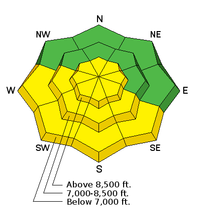
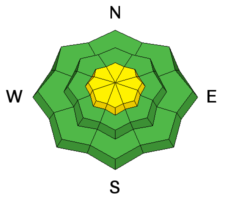
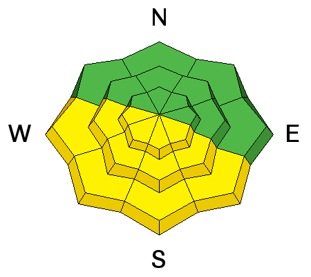
bottom line This morning the avalanche danger will be mostly LOW except at higher elevations on slopes loaded by today's increased NW winds where the danger is MODERATE. Additionally, the wet snow avalanche danger should rise to MODERATE this afternoon if some sunshine gets through this morning's cloudy skies.
|
 |
current conditions A trace of snow may have fallen this morning. Temperatures are in the low 30's F at 8000 feet and in the mid 20's F at 9000 feet. Winds have increased since yesterday and are blowing about 10-15 mph from the NW with gusts of 20 mph. The sun appeared enough during the last two days to warm the snow surface and form a crust this morning on southerly aspects and low elevations. |
 |
recent activity Following Monday's storm there were many avalanches on Tuesday. These dry snow avalanches were breaking within the new snow. Yesterday the new snow had settled and become much less senistive to sliding. However, one surprinsing avalanche was intentionally triggered in the Mill Creek drainage of SLC near Gobblers Knob in Depth Hoar bowl. This slide reportedly broke 16 inches deep and 200 feet wide. We have few details on it. Cloud cover and cool air temperatures prevented most wet snow avalanches yesterday. High temperatures yesterday reached the low to mid 30's F below 8000 feet and the snow became wet but not unstable. |
| type | aspect/elevation | characteristics |
|---|

|
|
LIKELIHOOD
 LIKELY
UNLIKELY
SIZE
 LARGE
SMALL
TREND
 INCREASING DANGER
SAME
DECREASING DANGER
|
|
description
Yesterday my partners and I skied a NW aspect on Gobblers Knob where the new snow was well bonded to the ice crust underneath it. We got one small piece of snow to move about 10 feet downhill on the crust. This snow wasn't much wider than a ski length and was mainly a sign of instabilities from Tuesday. I was surprised to hear about the slide in nearby Depth Hoar bowl. Overall however, the new snow has stabilized since Monday's storm. Avalanches may occur on slopes not affected by the wind in isolated places, but they will be more likely on slopes loaded by increased NW winds today. |
| type | aspect/elevation | characteristics |
|---|

|
|
LIKELIHOOD
LIKELY
UNLIKELY
SIZE
LARGE
SMALL
TREND
 INCREASING DANGER
SAME
DECREASING DANGER
|
|
description
Cloud cover and cool temperatures should limit wet snow avalanches today. BUT, the sun is strong enough this time of year that it doesn't need much time to heat the upper foot of snow and cause loose wet snow avalanches. A skier near Snowbasin easily triggered loose, wet snow slides on Tuesday when skies cleared and temperatures quickly warmed. If skies remain cloudy and air temperatures remain cool, there shouldn't be any wet snow avalanches. The best chance for warming and some sunshine should be this afternoon. |
 |
weather Snow is falling this morning and another inch or two may accumulate today. Skies should remain cloudy for most of the day and high temperatures at 9000 feet should reach the upper 20's F. At 7000 feet temperatures should reach the low 40's F. Winds will continue from the NW and blow 20 mph at ridgetops. |
| general announcements Remember your information can save lives. If you see anything we should know about, please help us out by submitting snow and avalanche conditions. You can also call us at 801-524-5304, email by clicking HERE, or include #utavy in your tweet or Instagram. To get help in an emergency (to request a rescue) in the Wasatch, call 911. Be prepared to give your GPS coordinates or the run name. Dispatchers have a copy of the Wasatch Backcountry Ski map. Backcountry Emergencies. It outlines your step-by-step method in the event of a winter backcountry incident. If you trigger an avalanche in the backcountry, but no one is hurt and you do not need assistance, please notify the nearest ski area dispatch to avoid a needless response by rescue teams. Thanks.
EMAIL ADVISORY If you would like to get the daily advisory by email you will need to subscribe here. DAWN PATROL Hotline updated daily by 5-530am - 888-999-4019 option 8. TWITTER Updates for your mobile phone - DETAILS UDOT canyon closures: LINK TO UDOT, or on Twitter, follow @UDOTavy, @CanyonAlerts or @AltaCentral Utah Avalanche Center mobile app - Get your advisory on your iPhone along with great navigation and rescue tools. Powderbird Helicopter Skiing - Blog/itinerary for the day Lost or Found something in the backcountry? - http://nolofo.com/ To those skinning uphill at resorts: it is critical to know the resort policy on uphill travel. You can see the uphill travel policy for each resort here. Benefit the Utah Avalanche Center when you shop from Backcountry.com or REI: Click this link for Backcountry.com or this link to REI, shop, and they will donate a percent of your purchase price to the UAC. Both offer free shipping (with some conditions) so this costs you nothing! Benefit the Utah Avalanche Center when you buy or sell on ebay - set the Utah Avalanche Center as a favorite non-profit in your ebay account here and click on ebay gives when you buy or sell. You can choose to have your seller fees donated to the UAC, which doesn't cost you a penny. This information does not apply to developed ski areas or highways where avalanche control is normally done. This advisory is from the U.S.D.A. Forest Service, which is solely responsible for its content. This advisory describes general avalanche conditions and local variations always exist. |


