| Please join us at the 23rd annual Black Diamond Fall Fundraiser Party Thursday Sept 15. Tickets are on sale now here, at the Black Diamond store & at REI. Special bonus raffle for online ticket purchasers! |
| Please join us at the 23rd annual Black Diamond Fall Fundraiser Party Thursday Sept 15. Tickets are on sale now here, at the Black Diamond store & at REI. Special bonus raffle for online ticket purchasers! |
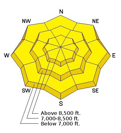
| Advisory: Ogden Area Mountains | Issued by Brett Kobernik for Wednesday - March 30, 2016 - 7:01am |
|---|

|
bottom line The overall avalanche danger is on the high end of MODERATE today. There is a good chance that someone will trigger a large enough avalanche to be dangerous. With all the new snow, wet avalanche activity is also a legitimate concern. Don't just go for your favorite big line right off the get go!! You're going to need to think it through today. Let the snow stability dictate your terrain choice.
|
 |
current conditions A few more inches of snow fell overnight brining storm totals up to 16 to 25 inches. Southeast wind did stir things up a bit in the higher terrain making the new snow vary in depth from place to place. The wind has really backed off and is generally light from the south. Periods of sun on Tuesday heated the snow on many slopes and they will be crusted this morning. Overnight temperatures were pretty cool with readings just dipping into the teens along the higher ridges. |
 |
recent activity It was a very active day on Tuesday. Most people who got out in the backcountry noted how sensitive the new snow was. Wet loose snow avalanches were easy to initiate in the afternoon and were packing a punch. While conditions were touchy, they also seemed easy to identify and predictable to a certain extent. |
| type | aspect/elevation | characteristics |
|---|

|
|
LIKELIHOOD
 LIKELY
UNLIKELY
SIZE
 LARGE
SMALL
TREND
 INCREASING DANGER
SAME
DECREASING DANGER
|
|
description
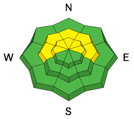
A layer of low density snow at the beginning of the storm seems to be the culprit weak layer in the avalanches from the last few days. This layer should stabilize fairly quickly (folks already noting this yesterday) although wind slabs may still release today especially in the areas that received the most snow. Keep in mind that the wind was from the southeast and loaded slopes that are a little out of the ordinary. |
| type | aspect/elevation | characteristics |
|---|

|
|
LIKELIHOOD
LIKELY
UNLIKELY
SIZE
LARGE
SMALL
TREND
 INCREASING DANGER
SAME
DECREASING DANGER
|
|
description
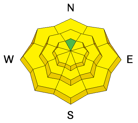
You can't hide from the sun at this time of the season. Even short periods of partial clearing can initiate wet activity. This is always most pronounced directly after new snowfall which we just had. Many slopes already went through a wet period on Tuesday and will be crusted and more stubborn today. Watch those more "off" aspects and some higher terrain today. Basically, beware of cold snow that gets rapidly heated for the first time. |
 |
weather It could be one of those springtime days that flip-flops back and forth between winter and spring. We should see plenty of clouds with occasional periods of snowfall. However, I would also anticipate the sun popping out here and there. Temperatures are going to be a few degrees warmer with ridgetop highs in the low to mid 30s. It will feel much warmer if the sun pops out. Wind should slowly switch more northerly and bump in speed slightly. Things are a bit unsettled on Thursday still then high pressure sets in for the weekend. |
| general announcements Remember your information can save lives. If you see anything we should know about, please help us out by submitting snow and avalanche conditions. You can also call us at 801-524-5304, email by clicking HERE, or include #utavy in your tweet or Instagram. To get help in an emergency (to request a rescue) in the Wasatch, call 911. Be prepared to give your GPS coordinates or the run name. Dispatchers have a copy of the Wasatch Backcountry Ski map. Backcountry Emergencies. It outlines your step-by-step method in the event of a winter backcountry incident. If you trigger an avalanche in the backcountry, but no one is hurt and you do not need assistance, please notify the nearest ski area dispatch to avoid a needless response by rescue teams. Thanks.
EMAIL ADVISORY If you would like to get the daily advisory by email you will need to subscribe here. DAWN PATROL Hotline updated daily by 5-530am - 888-999-4019 option 8. TWITTER Updates for your mobile phone - DETAILS UDOT canyon closures: LINK TO UDOT, or on Twitter, follow @UDOTavy, @CanyonAlerts or @AltaCentral Utah Avalanche Center mobile app - Get your advisory on your iPhone along with great navigation and rescue tools. Powderbird Helicopter Skiing - Blog/itinerary for the day Lost or Found something in the backcountry? - http://nolofo.com/ To those skinning uphill at resorts: it is critical to know the resort policy on uphill travel. You can see the uphill travel policy for each resort here. Benefit the Utah Avalanche Center when you shop from Backcountry.com or REI: Click this link for Backcountry.com or this link to REI, shop, and they will donate a percent of your purchase price to the UAC. Both offer free shipping (with some conditions) so this costs you nothing! Benefit the Utah Avalanche Center when you buy or sell on ebay - set the Utah Avalanche Center as a favorite non-profit in your ebay account here and click on ebay gives when you buy or sell. You can choose to have your seller fees donated to the UAC, which doesn't cost you a penny. This information does not apply to developed ski areas or highways where avalanche control is normally done. This advisory is from the U.S.D.A. Forest Service, which is solely responsible for its content. This advisory describes general avalanche conditions and local variations always exist. |


