| Please join us at the 23rd annual Black Diamond Fall Fundraiser Party Thursday Sept 15. Tickets are on sale now here, at the Black Diamond store & at REI. Special bonus raffle for online ticket purchasers! |
| Please join us at the 23rd annual Black Diamond Fall Fundraiser Party Thursday Sept 15. Tickets are on sale now here, at the Black Diamond store & at REI. Special bonus raffle for online ticket purchasers! |
| Advisory: Ogden Area Mountains | Issued by Mark Staples for Thursday - March 24, 2016 - 7:10am |
|---|

|
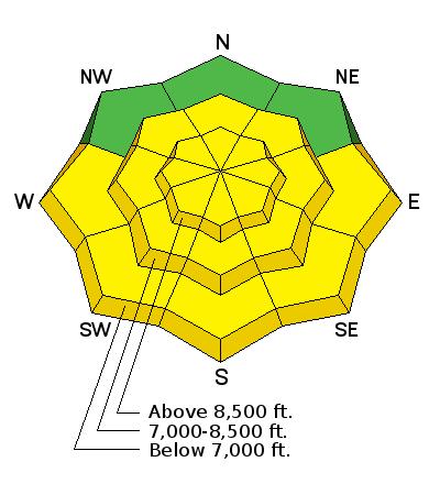
bottom line The danger of loose, wet snow avalanches is MODERATE today mainly on southerly aspects but it depends strongly on cloud cover. More clouds mean less danger, more sun means more danger. Wind slabs formed during strong NW winds Tuesday night/Wednesday morning will make the danger MODERATE on wind loaded slopes at mid and upper elevations. Generally safe conditions and a LOW danger exists on slopes sheltered from the sun and wind where the best snow can be found as well.
|
 |
special announcement Spring powder special! We have reduced the price of donated Snowbasin lift tickets to $50, half of window price. Take advantage of blower powder on a fat snowpack and benefit the Utah Avalanche Center at the same time. http://goo.gl/ZBG44W. Other donated tickets to Snowbird, Sundance, and Nordic Valley can be found HERE at reduced prices. Every penny on these donated tickets benefits the Utah Avalanche Center. |
 |
current conditions This morning temperatures at 9000 ft are 20 degrees F with temperatures at 8000 ft in the upper 20's F. Winds are blowing 10-15 mph gusting to 25 mph from the WSW. Plentiful sunshine in the Ogden area made the snow on south aspects become wet. Decent snow could be found above 8000 feet on slopes shaded from the sun and wind. |
 |
recent activity Yesterday wind slabs and loose, wet snow avalanches occurred. Ski patrols triggered small wind slabs along ridgelines. In the backcountry near Snowbasin, skiers triggered loose, wet snow avalanches in Hells Canyon. Photo below of a small wind slab on a test slope at 8900 feet (B. Hunt)
|
| type | aspect/elevation | characteristics |
|---|

|

|
LIKELIHOOD
 LIKELY
UNLIKELY
SIZE
 LARGE
SMALL
TREND
 INCREASING DANGER
SAME
DECREASING DANGER
|
|
description
The danger or loose wet snow avalanches depends on cloud cover today, but this time of year it doesn't take much sun make the snow on south aspects become wet. As the snow becomes wet, loose wet snow avalanches become more likely. The simple solution is to go to northerly facing slopes or other ones shaded from the sun where you will find dry snow and no danger of wet snow avalanches. |
| type | aspect/elevation | characteristics |
|---|

|

|
LIKELIHOOD
 LIKELY
UNLIKELY
SIZE
LARGE
SMALL
TREND
 INCREASING DANGER
SAME
DECREASING DANGER
|
|
description
You can still trigger wind slabs today but it should be harder to do. Fortunately, wind slabs are easy to see and avoid, especially if you go to low and mid elevations on wind sheltered slopes. Search for soft snow unaffected by the wind and you'll avoid wind slabs. |
| type | aspect/elevation | characteristics |
|---|

|
|
LIKELIHOOD
LIKELY
UNLIKELY
SIZE
LARGE
SMALL
TREND
INCREASING DANGER
SAME
DECREASING DANGER
|
|
description
New snow from Tuesday night plus NW winds helped grow cornices which should break easily today. Many experienced mountaineers have been surprised by how far back cornices will break. Give large cornices a wide berth. |
 |
weather Today will have a mix of sun and clouds. Air temperatures above 9000 feet should climb into the upper 20s F. At lower elevations, temperatures may reach 40 degrees F. Winds will continue blowing westerly 10-15 mph with some higher gusts. They will increase some this afternoon and switch to the NW with a cold front moving over the area tonight bringing some snow. By tomorrow morning there should be 1-2 inches of new snow with another small shot of snow coming Friday night. |
| general announcements Remember your information can save lives. If you see anything we should know about, please help us out by submitting snow and avalanche conditions. You can also call us at 801-524-5304, email by clicking HERE, or include #utavy in your tweet or Instagram. To get help in an emergency (to request a rescue) in the Wasatch, call 911. Be prepared to give your GPS coordinates or the run name. Dispatchers have a copy of the Wasatch Backcountry Ski map. Backcountry Emergencies. It outlines your step-by-step method in the event of a winter backcountry incident. If you trigger an avalanche in the backcountry, but no one is hurt and you do not need assistance, please notify the nearest ski area dispatch to avoid a needless response by rescue teams. Thanks.
EMAIL ADVISORY If you would like to get the daily advisory by email you will need to subscribe here. DAWN PATROL Hotline updated daily by 5-530am - 888-999-4019 option 8. TWITTER Updates for your mobile phone - DETAILS UDOT canyon closures: LINK TO UDOT, or on Twitter, follow @UDOTavy, @CanyonAlerts or @AltaCentral Utah Avalanche Center mobile app - Get your advisory on your iPhone along with great navigation and rescue tools. Powderbird Helicopter Skiing - Blog/itinerary for the day Lost or Found something in the backcountry? - http://nolofo.com/ To those skinning uphill at resorts: it is critical to know the resort policy on uphill travel. You can see the uphill travel policy for each resort here. Benefit the Utah Avalanche Center when you shop from Backcountry.com or REI: Click this link for Backcountry.com or this link to REI, shop, and they will donate a percent of your purchase price to the UAC. Both offer free shipping (with some conditions) so this costs you nothing! Benefit the Utah Avalanche Center when you buy or sell on ebay - set the Utah Avalanche Center as a favorite non-profit in your ebay account here and click on ebay gives when you buy or sell. You can choose to have your seller fees donated to the UAC, which doesn't cost you a penny. This information does not apply to developed ski areas or highways where avalanche control is normally done. This advisory is from the U.S.D.A. Forest Service, which is solely responsible for its content. This advisory describes general avalanche conditions and local variations always exist. |


.jpg)