| Please join us at the 23rd annual Black Diamond Fall Fundraiser Party Thursday Sept 15. Tickets are on sale now here, at the Black Diamond store & at REI. Special bonus raffle for online ticket purchasers! |
| Please join us at the 23rd annual Black Diamond Fall Fundraiser Party Thursday Sept 15. Tickets are on sale now here, at the Black Diamond store & at REI. Special bonus raffle for online ticket purchasers! |
| Advisory: Ogden Area Mountains | Issued by Evelyn Lees for Monday - March 21, 2016 - 6:52am |
|---|

|
bottom line There is MODERATE avalanche danger for triggering wet loose sluffs as the day heats up on just about all aspects and elevations. Get off steep slopes when the snow becomes wet and sloppy. Also use Normal Caution as you travel through the backcountry - watch out for any new wind drifts, don’t hang out in terrain below glide cracks and avoid travel on and below cornices.
|
 |
special announcement PLEASE HELP guide our discussions of website maintenance, upgrades or possible changes in coming years. Take this brief survey. As a way of saying thanks we'll be raffling a free avalanche class and other free stuff like hats, beanies, water bottles, etc. Do you need lift tickets to Snowbird, Snowbasin, Sundance, or Nordic Valley? Purchase them HERE at reduced prices. Every penny on these donated tickets benefits the Utah Avalanche Center. Check out our Garage Sale! Chock full of sweet backcountry gear - you can find the goods on our Facebook page here. |
 |
current conditions A warm southwest flow thin clouds kept overnight temperatures very warm in the Ogden area mountains – almost all mid and low elevation stations are in the 40s this morning, with only the highest peaks in the 30s. Overnight, along the highest ridges, the southwesterly winds averaged 35 to 40 mph, gusting to 60, for a period. For now, they have decreased into the 20 to 30 mph range.
The last bastion of powder will be on high elevation, north facing slopes. Those chasing corn snow will have their work cut out, trying to find a window of soft supportable snow between the breakable crusts and mush. |
 |
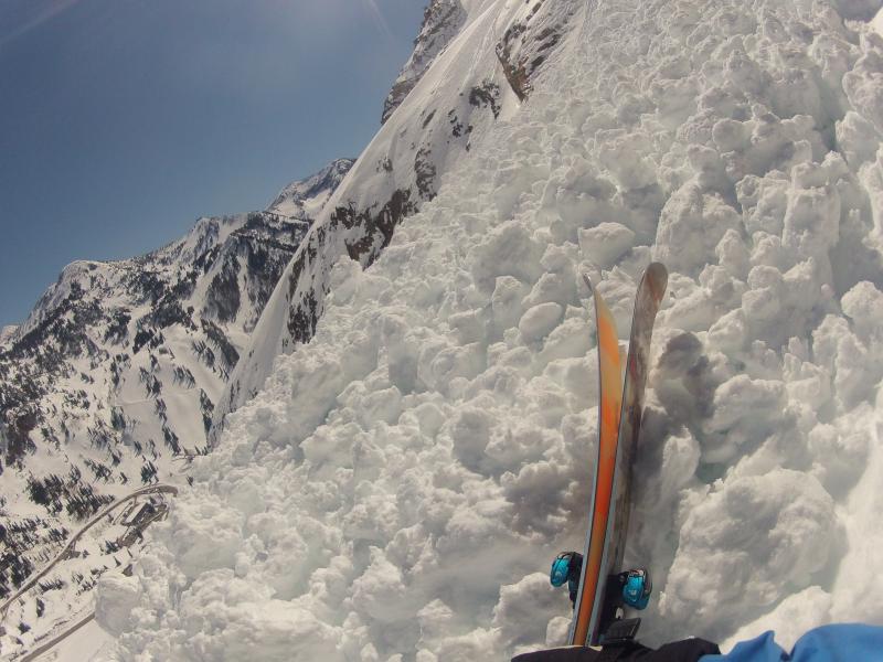
recent activity Yesterday afternoon in Little Cottonwood, there was a super close call – there were two separate groups on the south face of Superior, and the upper party triggered a wet loose sluff, narrowly missed a skier below on the apron. With 20/20 hindsight, the snow too warm for either party to be on the steep south-facing slope. But another take home is being aware of where other people are, both above and below you, when you’re in the backcountry. If you haven’t seen it, check out Drew’s video on the subject here.
K Hively’s photos of the wet slide debris on Superior from yesterday afternoon.
|
| type | aspect/elevation | characteristics |
|---|

|
|
LIKELIHOOD
 LIKELY
UNLIKELY
SIZE
 LARGE
SMALL
TREND
 INCREASING DANGER
SAME
DECREASING DANGER
|
|
description
Once again, triggering a wet loose sluff is the greatest concern for today. A poor overnight refreeze and super warm daytime temperatures will make the snow wet and soggy on some slopes today, including the shady, northerly facing slopes. Hopefully, periods of clouds and brisk southwesterly winds will help offset the worst of the heating.
|
| type | aspect/elevation | characteristics |
|---|

|

|
LIKELIHOOD
 LIKELY
UNLIKELY
SIZE
LARGE
SMALL
TREND
INCREASING DANGER
SAME
DECREASING DANGER
|
|
description
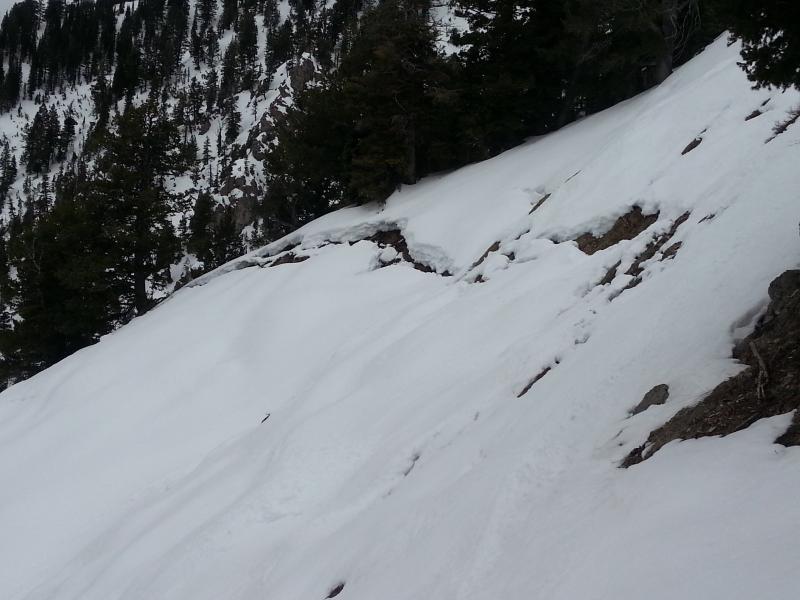
Glide avalanches continue to occur at irregular intervals, but would logically be a bit more likely with the current warm temperatures, so minimize your time beneath any growing cracks. Glide avalanches typically occur where the snow is underlain with smooth rock slabs. Cornices are dropping, and often break back further than expected. Winds slabs – there certainly isn’t much loose snow left for the winds to blow around, but there could be a few new wind drifts along the upper elevation ridge lines to identify and avoid, mostly on northerly facing slopes. Classic Ogden area mountains glide crack, from about a week ago - Bill Hunt photo
|
 |
weather It’s going to be a breezy, warm day, with periods of thin to very thick high clouds. Ridge line temperatures will be in the mid to upper 30s, and 8,000’ temperatures will warm into the upper 50s. The gusty southwesterly winds will average 15 to 25 mph, with the high ridge lines averaging 30 to 35 mph, with gusts to 60. Warm and mostly cloudy tonight, with a few light rain and snow showers after midnight. The cold front will arrive around dawn tomorrow, with gusty northwesterly winds, and 8 to 16” of snow possible by Wednesday evening. This will be another spring-like convective storm, with graupel, possible lightning, and variable snow amounts. |
| general announcements Remember your information can save lives. If you see anything we should know about, please help us out by submitting snow and avalanche conditions. You can also call us at 801-524-5304, email by clicking HERE, or include #utavy in your tweet or Instagram. To get help in an emergency (to request a rescue) in the Wasatch, call 911. Be prepared to give your GPS coordinates or the run name. Dispatchers have a copy of the Wasatch Backcountry Ski map. Backcountry Emergencies. It outlines your step-by-step method in the event of a winter backcountry incident. If you trigger an avalanche in the backcountry, but no one is hurt and you do not need assistance, please notify the nearest ski area dispatch to avoid a needless response by rescue teams. Thanks.
EMAIL ADVISORY If you would like to get the daily advisory by email you will need to subscribe here. DAWN PATROL Hotline updated daily by 5-530am - 888-999-4019 option 8. TWITTER Updates for your mobile phone - DETAILS UDOT canyon closures: LINK TO UDOT, or on Twitter, follow @UDOTavy, @CanyonAlerts or @AltaCentral Utah Avalanche Center mobile app - Get your advisory on your iPhone along with great navigation and rescue tools. Powderbird Helicopter Skiing - Blog/itinerary for the day Lost or Found something in the backcountry? - http://nolofo.com/ To those skinning uphill at resorts: it is critical to know the resort policy on uphill travel. You can see the uphill travel policy for each resort here. Benefit the Utah Avalanche Center when you shop from Backcountry.com or REI: Click this link for Backcountry.com or this link to REI, shop, and they will donate a percent of your purchase price to the UAC. Both offer free shipping (with some conditions) so this costs you nothing! Benefit the Utah Avalanche Center when you buy or sell on ebay - set the Utah Avalanche Center as a favorite non-profit in your ebay account here and click on ebay gives when you buy or sell. You can choose to have your seller fees donated to the UAC, which doesn't cost you a penny. This information does not apply to developed ski areas or highways where avalanche control is normally done. This advisory is from the U.S.D.A. Forest Service, which is solely responsible for its content. This advisory describes general avalanche conditions and local variations always exist. |