| Please join us at the 23rd annual Black Diamond Fall Fundraiser Party Thursday Sept 15. Tickets are on sale now here, at the Black Diamond store & at REI. Special bonus raffle for online ticket purchasers! |
| Please join us at the 23rd annual Black Diamond Fall Fundraiser Party Thursday Sept 15. Tickets are on sale now here, at the Black Diamond store & at REI. Special bonus raffle for online ticket purchasers! |
| Advisory: Ogden Area Mountains | Issued by Drew Hardesty for Monday - March 7, 2016 - 7:15am |
|---|

|
bottom line A great deal of uncertainty accompanies this forecast. A MODERATE danger exists on all aspects and elevations due to wind drifts, storm snow instabilities, and perhaps particularly on the low to mid elevation northerly terrain hammered by rain yesterday. It may be possible to gouge out some wet avalanches in poorly consolidated snow in steep terrain. Safer and probably better riding conditions can be found in the wind protected 8500'-9500' elevations on 30° slopes.
|
 |
special announcement The Utah Avalanche Center greatly values our longtime partnership with our world-class resorts and is blowing out the remaining donated lift tickets from Snowbird, Snowbasin, Sundance, and Nordic Valley with reduced prices. Every penny you spend benefits the Utah Avalanche Center. Check out our Garage Sale! Chock full of sweet backcountry gear - you can find the goods on our Facebook page here. |
 |
current conditions I took it as a sign of the Apocalypse. Pre-frontal southerly winds raged 35-50mph with gusts to 70. A rain/snow line to 8000'. Graupel pellets flew sideways. 2" of snow became 2' drifts. Thunder and lightning at two minutes after 5pm. Whiteout and no visibilty. Snowing 2"/hour as foretold. Perhaps I've been reading too much Cormac McCarthy. Now, many hours later...it's still snowing, albeit lightly. A cool 1" of precipitation across the range; though how this translates to snow depends loosely upon elevation. Tables for storm snow/water below. Temperatures have fallen to the mid teens to low 20s. Winds are moderate from the west-northwest at most elevations, though the anemometers at 11,000' spin at 40 gusting to 50. They should remain breezy through the morning.
Skiing and riding conditions should be quite good above 8500', as the graupel and decreasing densities should at once smooth over the rough corrugated surfaces and provide for good floatation. The lower elevations suffered a good rain event with a few inches of insulating snow above, trapping the heat. Expect perhaps punchy and poorly consolidated wet grains below 8000'.
|
 |
recent activity Prudently, few were out and about yesterday. Still, I noted natural cornice-fall triggered shallow wind pockets along the lee of the PC ridgeline in the afternoon. Snow safety teams noted one size 2 natural avalanche in upper Little Cottonwood. No reports of significant activity in the Ogden area mountains.
|
| type | aspect/elevation | characteristics |
|---|

|

|
LIKELIHOOD
 LIKELY
UNLIKELY
SIZE
 LARGE
SMALL
TREND
 INCREASING DANGER
SAME
DECREASING DANGER
|
|
description
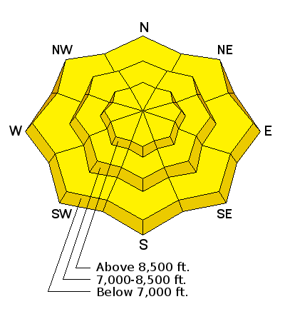
If you're traveling in terrain above 9500', it's likely you'll trigger a freshly loaded wind drift in the steep terrain on north to east to south facing slopes. The sensitivity will be at its highest this morning and gradually gain strength over the course of the day. The disclaimer, of course, is fundamentally rooted in the cloud cover. Direct sun may keep these instabilities on the front burner so travel accordingly.
|
| type | aspect/elevation | characteristics |
|---|

|

|
LIKELIHOOD
LIKELY
UNLIKELY
SIZE
LARGE
SMALL
TREND
 INCREASING DANGER
SAME
DECREASING DANGER
|
|
description
Storm snow instabilities should also begin to heal by later in the day. The danger will be most pronounced in areas that received more then 6-8" of snow. Anticipate graupel pooling at slope angle transitions (eg: 45 degree slope abruptly transitioning to 37 degrees) and below cliffbands. |
| type | aspect/elevation | characteristics |
|---|

|

|
LIKELIHOOD
LIKELY
UNLIKELY
SIZE
LARGE
SMALL
TREND
INCREASING DANGER
SAME
DECREASING DANGER
|
|
description
A tough one. Great uncertainty. On one hand, some of the snow pillows at the snotel sites indicated water coming into the snowpack...and then water draining out. This is a good sign. On the other hand, snow falling on a snowpack previously drenched by rain will insulate the snowpack and prevent a good "lock-up" of the snow. An observer out of Logan flushed some significant wet debris in poorly consolidated snow out of a steep chute yesterday afternoon. This type of snow regime may gouge deeply into the slurpee-like snow. This is more pronounced on the northerly aspects... |
 |
weather I'd anticipate some partial clearing to begin by mid-morning. Temperatures will be in the upper teens along the high ridgelines, the low 30s at 8000'. West-northwest winds, while moderate to strong this morning, should diminish through out the course of the day. Expect 10-15mph winds by early afternoon. The next storm dives sharply to the south but we'll see the northern branch of the storm produce some clouds and a few straggler flurries, particularly near the Logan mountains. Continued moisture moves in on a westerly track over the next couple of days before drying out late week. Longer range models suggest unsettled weather moving in through the weekend and into next week. |
| general announcements Remember your information can save lives. If you see anything we should know about, please help us out by submitting snow and avalanche conditions. You can also call us at 801-524-5304, email by clicking HERE, or include #utavy in your tweet or Instagram. To get help in an emergency (to request a rescue) in the Wasatch, call 911. Be prepared to give your GPS coordinates or the run name. Dispatchers have a copy of the Wasatch Backcountry Ski map. Backcountry Emergencies. It outlines your step-by-step method in the event of a winter backcountry incident. If you trigger an avalanche in the backcountry, but no one is hurt and you do not need assistance, please notify the nearest ski area dispatch to avoid a needless response by rescue teams. Thanks.
EMAIL ADVISORY If you would like to get the daily advisory by email you will need to subscribe here. DAWN PATROL Hotline updated daily by 5-530am - 888-999-4019 option 8. TWITTER Updates for your mobile phone - DETAILS UDOT canyon closures: LINK TO UDOT, or on Twitter, follow @UDOTavy, @CanyonAlerts or @AltaCentral Utah Avalanche Center mobile app - Get your advisory on your iPhone along with great navigation and rescue tools. Powderbird Helicopter Skiing - Blog/itinerary for the day Lost or Found something in the backcountry? - http://nolofo.com/ To those skinning uphill at resorts: it is critical to know the resort policy on uphill travel. You can see the uphill travel policy for each resort here. Benefit the Utah Avalanche Center when you shop from Backcountry.com or REI: Click this link for Backcountry.com or this link to REI, shop, and they will donate a percent of your purchase price to the UAC. Both offer free shipping (with some conditions) so this costs you nothing! Benefit the Utah Avalanche Center when you buy or sell on ebay - set the Utah Avalanche Center as a favorite non-profit in your ebay account here and click on ebay gives when you buy or sell. You can choose to have your seller fees donated to the UAC, which doesn't cost you a penny. This information does not apply to developed ski areas or highways where avalanche control is normally done. This advisory is from the U.S.D.A. Forest Service, which is solely responsible for its content. This advisory describes general avalanche conditions and local variations always exist. |