| Please join us at the 23rd annual Black Diamond Fall Fundraiser Party Thursday Sept 15. Tickets are on sale now here, at the Black Diamond store & at REI. Special bonus raffle for online ticket purchasers! |
| Please join us at the 23rd annual Black Diamond Fall Fundraiser Party Thursday Sept 15. Tickets are on sale now here, at the Black Diamond store & at REI. Special bonus raffle for online ticket purchasers! |
| Advisory: Ogden Area Mountains | Issued by Evelyn Lees for Monday - February 22, 2016 - 7:23am |
|---|

|
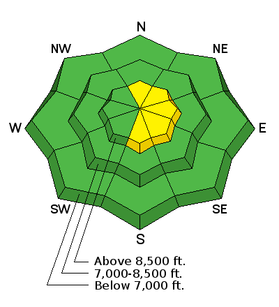
bottom line The avalanche danger is LOW this morning, but will increase to MODERATE on steep, wind-drifted slopes this afternoon. The MODERATE danger will be on upper elevation slopes approaching 35 degrees or steeper, where the new snow is getting blown into sensitive slabs by the northwesterly winds.
|
 |
special announcement Thursday 2/25 - Utah Adventure Journal presents adventure photographer Jim Harris at Snowbird's Wildflower Lounge. More Details Here. Check out our Garage Sale! Chock full of sweet backcountry gear - you can find the goods on our Facebook page here. |
 |
current conditions A small storm is on the doorstep, with light snow just starting to fall in some areas of the mountains. Temperatures are in the 20s and 30s in the Ogden area mountains, and the northwesterly winds are light, with most stations in the 5 to 10 mph range. Even Mt Ogden is only averaging 16 mph, with gusts to 23.
We are ready for a refill - while there is excellent dry powder on upper elevation northerly facing slopes, most other terrain is frozen and crusted this morning. Travel with care, as a slip on one of the steep, icy slopes could have you rocketing downhill with little chance for stopping.
|
 |
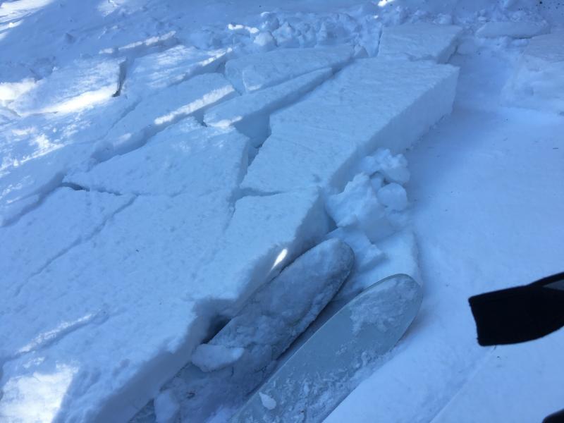
recent activity There was one report of a small wind slab being triggered in the Ogden area mountains, and a some minor heat related activity. Other than that, no other reports of recent avalanches, with steep slopes heavily tracked over the weekend. Small, 15' wide wind slab triggered yesterday, upper elevation terrain in the Odgen area mountains.
|
| type | aspect/elevation | characteristics |
|---|

|
|
LIKELIHOOD
 LIKELY
UNLIKELY
SIZE
 LARGE
SMALL
TREND
 INCREASING DANGER
SAME
DECREASING DANGER
|
|
description
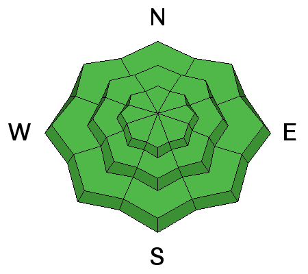
Remember, risk is always inherent in mountain travel. Even with a Low Danger, avalanches can still happen in isolated places.
|
| type | aspect/elevation | characteristics |
|---|

|
|
LIKELIHOOD
LIKELY
UNLIKELY
SIZE
LARGE
SMALL
TREND
 INCREASING DANGER
SAME
DECREASING DANGER
|
|
description
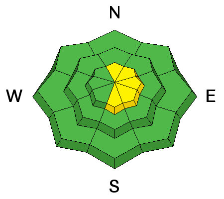
As winds pick up later this afternoon, watch for and avoid any new drifts that form on steep slopes. This will mainly be an issue if you are in an area where there is both the heavier snowfall and steady winds. If so, constantly evaluate the conditions, and be prepared to head to lower angle slopes or out of the wind affected terrain. |
 |
weather A disturbance bringing light snow this morning will become enhanced as a second disturbance arrives from the Pacific Northwest this afternoon. Most areas should receive a few inches of snow by noon, with more intense squalls possible this afternoon through this evening. The cold air with the second system will bring the potential for isolated lightning and brief periods of higher snow rates, up to 2” per hour. The northwesterly winds will also increase this afternoon, with the high peaks averaging 25 to 35 mph, gusting to 50 mph. Snowfall amounts will not be uniform - average totals by this evening should be in the 3 to 5” range, with a few lucky areas getting a bit more.
Temperatures will start to fall this afternoon, bottoming out near 10 degrees along the high ridge lines on Tuesday morning. A ridge of high pressure will settle in Tuesday afternoon, bringing warm temperatures and sunny skies through Friday. Next possibility for snow is Saturday night. |
| general announcements Remember your information can save lives. If you see anything we should know about, please help us out by submitting snow and avalanche conditions. You can also call us at 801-524-5304, email by clicking HERE, or include #utavy in your tweet or Instagram. To get help in an emergency (to request a rescue) in the Wasatch, call 911. Be prepared to give your GPS coordinates or the run name. Dispatchers have a copy of the Wasatch Backcountry Ski map. Backcountry Emergencies. It outlines your step-by-step method in the event of a winter backcountry incident. If you trigger an avalanche in the backcountry, but no one is hurt and you do not need assistance, please notify the nearest ski area dispatch to avoid a needless response by rescue teams. Thanks.
EMAIL ADVISORY If you would like to get the daily advisory by email you will need to subscribe here. DAWN PATROL Hotline updated daily by 5-530am - 888-999-4019 option 8. Twitter Updates for your mobile phone - DETAILS UDOT canyon closures: LINK TO UDOT, or on Twitter, follow @UDOTavy, @CanyonAlerts or @AltaCentral Utah Avalanche Center mobile app - Get your advisory on your iPhone along with great navigation and rescue tools. Powderbird Helicopter Skiing - Blog/itinerary for the day Lost or Found something in the backcountry? - http://nolofo.com/ To those skinning uphill at resorts: it is critical to know the resort policy on uphill travel. You can see the uphill travel policy for each resort here. Benefit the Utah Avalanche Center when you shop from Backcountry.com or REI: Click this link for Backcountry.com or this link to REI, shop, and they will donate a percent of your purchase price to the UAC. Both offer free shipping (with some conditions) so this costs you nothing! Benefit the Utah Avalanche Center when you buy or sell on ebay - set the Utah Avalanche Center as a favorite non-profit in your ebay account here and click on ebay gives when you buy or sell. You can choose to have your seller fees donated to the UAC, which doesn't cost you a penny.
|


 This information does not apply to developed ski areas or highways where avalanche control is normally done. This advisory is from the U.S.D.A. Forest Service, which is solely responsible for its content. This advisory describes general avalanche conditions and local variations always exist.