| Please join us at the 23rd annual Black Diamond Fall Fundraiser Party Thursday Sept 15. Tickets are on sale now here, at the Black Diamond store & at REI. Special bonus raffle for online ticket purchasers! |
| Please join us at the 23rd annual Black Diamond Fall Fundraiser Party Thursday Sept 15. Tickets are on sale now here, at the Black Diamond store & at REI. Special bonus raffle for online ticket purchasers! |
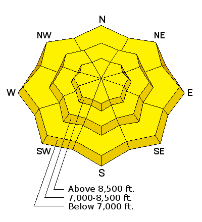
| Advisory: Ogden Area Mountains | Issued by Brett Kobernik for Wednesday - February 17, 2016 - 6:41am |
|---|

|
bottom line The overall avalanche danger is MODERATE today. Heat related avalanche activity on the sunnier slopes is your main focus. Get off of and out from underneath steep slopes as they become wet during the day.
|
 |
special announcement Companion Rescue Fundamentals Course at Brighton, Friday, February 19th. Click for more info. HERE
|
 |
current conditions People reported interesting snow surface conditions on Tuesday. This was caused by a windy storm on Monday with dense snow and also included a good dose of riming. Crusts vary from thick and supportable to thin and "ridable". Sunny slopes heated up on Tuesday so anticipate a melt freeze crust on them this morning. These crusts will be short lived with the very mild overnight temperatures we have. Many stations have actually been increasing in temperature over the last 6 hours with readings in the mid 30s at the higher stations. Wind speeds are fairly light from the southwest with a few stations hinting at a south southeast direction. |
 |
recent activity No significant avalanche activity was reported from Tuesday. |
| type | aspect/elevation | characteristics |
|---|

|
|
LIKELIHOOD
 LIKELY
UNLIKELY
SIZE
 LARGE
SMALL
TREND
 INCREASING DANGER
SAME
DECREASING DANGER
|
|
description
Heat related avalanche activity is your biggest concern today. The extent of the activity I'm unsure of. High thin clouds and some wind may offset the heating and slow avalanche activity. That being said, you always need to pay attention to what the snow is doing during warming trends. Make sure you in a location with a quick exit if the snow starts to become really wet and you are starting to see natural activity. Use extra caution in the lower elevations where things are quite saturated. |
| type | aspect/elevation | characteristics |
|---|

|

|
LIKELIHOOD
 LIKELY
UNLIKELY
SIZE
 LARGE
SMALL
TREND
 INCREASING DANGER
SAME
DECREASING DANGER
|
|
description
Some folks noted some clean shears at the new snow/old snow interface on Tuesday. There was one report of a collapse which turned out to be some buried near surface facets from the last period of high pressure. Overall, the new snow seems to be pretty stable but it's worth mentioning that you may find a place or two where you could pop out a small slab. Keep this in mind if you are planning on getting into unforgiving terrain. |
 |
weather We'll see some high clouds, warm temperatures and increasing wind as the day progresses. Ridgetop temperatures will get into the low to mid 40s. Southwest wind speeds will increase into the moderate speed range by mid day. A storm will move through on Thursday. The southwest wind looks very strong during the storm on Thursday morning. We should see 3 to 6 inches of snow. Temperatures start out quite mild with this storm and eventually cool into the low 20s. |
| general announcements Remember your information can save lives. If you see anything we should know about, please participate in the creation of our own community avalanche advisory by submitting snow and avalanche conditions. You can also call us at 801-524-5304, email by clicking HERE, or include #utavy in your tweet or Instagram. To get help in an emergency (to launch a rescue) in the Wasatch, call 911. Be prepared to give your GPS coordinates or the run name. Dispatchers have a copy of the Wasatch Backcountry Ski map. Backcountry Emergencies. It outlines your step-by-step method in the event of a winter backcountry incident. If you trigger an avalanche in the backcountry, but no one is hurt and you do not need assistance, please notify the nearest ski area dispatch to avoid a needless response by rescue teams. Thanks. Salt Lake and Park City – Alta Central (801-742-2033), Canyons Resort/PCMR Dispatch (435)615-1911 Snowbasin Resort Dispatch (801-620-1017), Powder Mountain Dispatch (801-745-3772 x 123). Sundance Dispatch (801-223-4150) EMAIL ADVISORY If you would like to get the daily advisory by email you will need to subscribe here. DAWN PATROL Hotline updated daily by 5-530am - 888-999-4019 option 8. Twitter Updates for your mobile phone - DETAILS UDOT canyon closures: LINK TO UDOT, or on Twitter, follow @UDOTavy, @CanyonAlerts or @AltaCentral Utah Avalanche Center mobile app - Get your advisory on your iPhone along with great navigation and rescue tools. Powderbird Helicopter Skiing - Blog/itinerary for the day Lost or Found something in the backcountry? - http://nolofo.com/ To those skinning uphill at resorts: it is your responsibility to know the resort policy on uphill travel. You can see the uphill travel policy for each resort here. IMPORTANT: Before skinning or hiking at a resort under new snow conditions, check in with Ski Patrol. Resorts can restrict or cut off access if incompatible with control and grooming operations. Benefit the Utah Avalanche Center when you shop from Backcountry.com or REI: Click this link for Backcountry.com or this link to REI, shop, and they will donate a percent of your purchase price to the UAC. Both offer free shipping (with some conditions) so this costs you nothing! Benefit the Utah Avalanche Center when you buy or sell on ebay - set the Utah Avalanche Center as a favorite non-profit in your ebay account here and click on ebay gives when you buy or sell. You can choose to have your seller fees donated to the UAC, which doesn't cost you a penny. This information does not apply to developed ski areas or highways where avalanche control is normally done. This advisory is from the U.S.D.A. Forest Service, which is solely responsible for its content. This advisory describes general avalanche conditions and local variations always exist. |


