| Please join us at the 23rd annual Black Diamond Fall Fundraiser Party Thursday Sept 15. Tickets are on sale now here, at the Black Diamond store & at REI. Special bonus raffle for online ticket purchasers! |
| Please join us at the 23rd annual Black Diamond Fall Fundraiser Party Thursday Sept 15. Tickets are on sale now here, at the Black Diamond store & at REI. Special bonus raffle for online ticket purchasers! |
| Advisory: Ogden Area Mountains | Issued by Evelyn Lees for Tuesday - February 16, 2016 - 7:20am |
|---|

|
bottom line The avalanche danger is MODERATE on all steep slopes today. Steep sunny slopes and all mid and lower elevation slopes have a MODERATE danger of wet loose sluffs as the day heats up. It may also be possible to trigger a few lingering wind drifts on upper elevation slopes facing northwest through southeast.
|
 |
special announcement With the freedom of the backcountry comes responsibility. The new video “Knowledge, Awareness and Wisdom” discusses expectations in the backcountry. Check it out https://vimeo.com/155468785 Tuesday, February 16th - Companion Rescue at Weller Recreation from 6:30-9pm. For more info HERE. There will be an Avalanche Awareness for Snowmobilers Course in near by Logan February 25 & 27. For more information https://goo.gl/aT1bYT |
 |
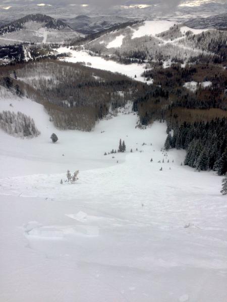
current conditions Skies are partly cloudy this morning in the Ogden area mountains, and temperatures are in the upper twenties to mid 30s. The southwesterly winds are still brisk along the upper elevation ridgelines, perhaps averaging 25 to 30 mph, but are much more civilized in the mid elevation terrain, averaging less than 10 mph, though still gusty. Upper elevation storm totals were 5-6” in the Ogden area mountains, with the rain/snow line creeping up to about 7 to 7,500’. However, I’m having trouble visualizing what happened next – an intense riming event that coated all aspects, all elevations in at least several areas of the Ogden area mountains. |
 |
recent activity In the Ogden area mountains, No avalanches were reported. There was minimal transport and activity, as the new snow was locked in with a coating of rime. Here is the report from the Salt Lake/Park City mountains: The only backcountry slide reported was released by an intentional ski cut in No Name on the Park City ridge line. The slide broke out 10 feet below the cut, and was new snow only, 6” – 12” deep by 150’ wide. This repeat offender is on a northeast facing slope at 9400’,and I suspect the old snow surface it failed on was near surface facets. Resort and highway avalanche reduction work in the Cottonwoods released numerous class 2 slides, mostly with explosives, on a variety of aspects.
Photos of No Name slide by McCurdy, Kemp, or Haggard
|
| type | aspect/elevation | characteristics |
|---|

|
|
LIKELIHOOD
 LIKELY
UNLIKELY
SIZE
 LARGE
SMALL
TREND
 INCREASING DANGER
SAME
DECREASING DANGER
|
|
description
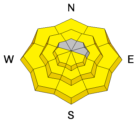
The snow on low and mid elevation slopes will be feeling the heat today as temperatures rise into the 40s, as will the snow on steep sunny slopes anytime the clouds thin. Wet sluffs will become easy to initiate, and a few natural avalanches are possible. Keep close track of the snow as it heats, and get off steep slopes before the snow becomes wet or soggy. The snow on steep, shady slopes at low and mid elevations will be especially easy to trigger.
House and building roofs are shedding their snow, too, and the debris can pile up deep enough to bury and kill a person. |
| type | aspect/elevation | characteristics |
|---|

|
|
LIKELIHOOD
 LIKELY
UNLIKELY
SIZE
LARGE
SMALL
TREND
 INCREASING DANGER
SAME
DECREASING DANGER
|
|
description
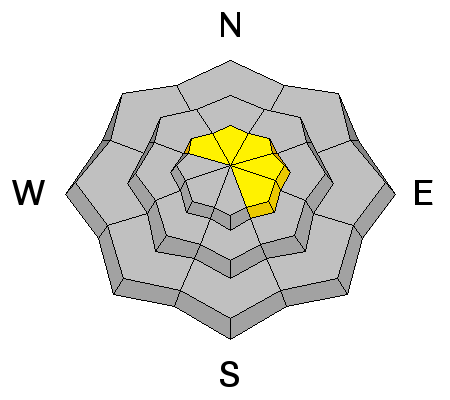
Despite of the rime gluing down the wind deposits, it still might be possible to trigger a new snow slide or rogue wind drift at the upper elevations, perhaps where there was still dry, sugary faceted snow on the surface before the storm or on a slope that got less riming. This video by Trent Meisenheimer takes a closer look at the continuing weak structure and snow in a repeater avalanche path. While it may not be relevant to the Ogden area snowpack, it's still a good educational video. Days Repeater from Trent Meisenheimer on Vimeo. |
 |
weather Low clouds and local riming could linger at a few lower elevations this morning, but will dissipate. However, a stream of high clouds will be over the area through the rest of the day, creating variable cloud cover. Temperatures will warm into the mid 40s at 8,000’ and into the low 30s along the high ridge lines. The southwesterly winds along the ridge lines will slowly decrease through out the day.
A warm, dry southwest flow will develop Wednesday, with ridge line temperatures soaring into the upper 30s to near 40 and winds increasing ahead of the Thursday cold front. |
| general announcements Remember your information can save lives. If you see anything we should know about, please participate in the creation of our own community avalanche advisory by submitting snow and avalanche conditions. You can also call us at 801-524-5304, email by clicking HERE, or include #utavy in your tweet or Instagram. To get help in an emergency (to launch a rescue) in the Wasatch, call 911. Be prepared to give your GPS coordinates or the run name. Dispatchers have a copy of the Wasatch Backcountry Ski map. Backcountry Emergencies. It outlines your step-by-step method in the event of a winter backcountry incident. If you trigger an avalanche in the backcountry, but no one is hurt and you do not need assistance, please notify the nearest ski area dispatch to avoid a needless response by rescue teams. Thanks. Salt Lake and Park City – Alta Central (801-742-2033), Canyons Resort/PCMR Dispatch (435)615-1911 Snowbasin Resort Dispatch (801-620-1017), Powder Mountain Dispatch (801-745-3772 x 123). Sundance Dispatch (801-223-4150) EMAIL ADVISORY If you would like to get the daily advisory by email you will need to subscribe here. DAWN PATROL Hotline updated daily by 5-530am - 888-999-4019 option 8. Twitter Updates for your mobile phone - DETAILS UDOT canyon closures: LINK TO UDOT, or on Twitter, follow @UDOTavy, @CanyonAlerts or @AltaCentral Utah Avalanche Center mobile app - Get your advisory on your iPhone along with great navigation and rescue tools. Powderbird Helicopter Skiing - Blog/itinerary for the day Lost or Found something in the backcountry? - http://nolofo.com/ To those skinning uphill at resorts: it is your responsibility to know the resort policy on uphill travel. You can see the uphill travel policy for each resort here. IMPORTANT: Before skinning or hiking at a resort under new snow conditions, check in with Ski Patrol. Resorts can restrict or cut off access if incompatible with control and grooming operations. Benefit the Utah Avalanche Center when you shop from Backcountry.com or REI: Click this link for Backcountry.com or this link to REI, shop, and they will donate a percent of your purchase price to the UAC. Both offer free shipping (with some conditions) so this costs you nothing! Benefit the Utah Avalanche Center when you buy or sell on ebay - set the Utah Avalanche Center as a favorite non-profit in your ebay account here and click on ebay gives when you buy or sell. You can choose to have your seller fees donated to the UAC, which doesn't cost you a penny. This information does not apply to developed ski areas or highways where avalanche control is normally done. This advisory is from the U.S.D.A. Forest Service, which is solely responsible for its content. This advisory describes general avalanche conditions and local variations always exist. |