| Please join us at the 23rd annual Black Diamond Fall Fundraiser Party Thursday Sept 15. Tickets are on sale now here, at the Black Diamond store & at REI. Special bonus raffle for online ticket purchasers! |
| Please join us at the 23rd annual Black Diamond Fall Fundraiser Party Thursday Sept 15. Tickets are on sale now here, at the Black Diamond store & at REI. Special bonus raffle for online ticket purchasers! |
| Advisory: Ogden Area Mountains | Issued by Drew Hardesty for Saturday - February 13, 2016 - 4:25am |
|---|

|
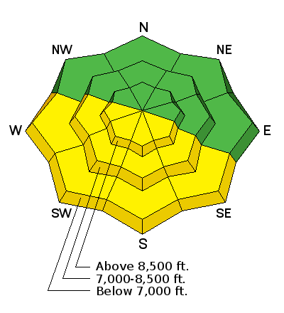
bottom line The avalanche danger is mostly low this morning. We have a Moderate danger on South (Solar) aspects due to wet loose avalanche problems this may rise to Considerable as these aspects start to heat up. Be aware of cornices today. Stay back give them room it has been over 48 hrs since they have seen a good freeze.
|
 |
special announcement Check out our Garage Sale! Chock full of sweet backcountry gear - you can find the goods on our Facebook page here - Tuesday, February 16th - Companion Rescue Clinic at Weller Recreation in Kamas from 6:30-9pm. For more info HERE. WBSKIING: Steve Achelis has released his updated Wasatch Backcountry Skiing desktop webpage - wbskiing.com Blog post - Guest blog post by George Vargyas, MD - Avalanche Trauma Mortality and Helmet Use. It may surprise you. |
 |
current conditions Today's advisory written by Kory Davis. It is warm again today with mid elevation (7,000-8,000 ft) weather stations reporting in the 40s and upper elevation stations reporting in the 30s. One outlier is the Ben Lomond Peak weather station at 8,000 ft is reporting 41 degrees. I do not think that a strong refreeze of the upper snowpack occurred last night. This could cause wet activity earlier in the day than expected. Some good news is that it was cooler last night than Thursday night and temperatures today will be a touch cooler than yesterday with Highs in the low 40s at upper elevations. Winds Last night were calm, Ridge winds were in the teens with gusts in the twenties. With a potential quick shot of snow on Sunday night get familiar with our current snow surface on East-North-Northwest aspects because todays snow surface could be tomorrows problem. This might only be 1-2 inches of new snow but with a little wind we could see deeper wind slabs on Monday and Tuesday.
|
 |
recent activity Small Wet Loose activity was noted in the Ogden Mountains but was limited to Southeast -Southwest Steep aspects. There was some collapsing reported on South aspects by the Ski Areas. |
| type | aspect/elevation | characteristics |
|---|

|
|
LIKELIHOOD
 LIKELY
UNLIKELY
SIZE
 LARGE
SMALL
TREND
 INCREASING DANGER
SAME
DECREASING DANGER
|
|
description
Once again, Solar Aspects will see wet activity this could be earlier than usual with a poor refreeze again last night. The danger could rise to considerable with daytime heating. Damp snow was reported as early as 11a.m. yesterday. Look for obvious signs of instability on solar aspects. Keep it simple quick pole drag tests and visual observations are key on sunny days. Today you can chase the shade around the compass. Poor refreezes at a number of mid-elevation weather stations begs the question of wet slab potential. Collapsing and unsupportable snow - along with free water in the snowpack - are red flags for today. |
| type | aspect/elevation | characteristics |
|---|

|
|
LIKELIHOOD
 LIKELY
UNLIKELY
SIZE
 LARGE
SMALL
TREND
 INCREASING DANGER
SAME
DECREASING DANGER
|
|
description
In the Ogden Mountains we have not seen any Persistent Deep Slab avalanches since Christmas, this does not mean they are gone, maybe just lurking waiting for the next storm or trigger. These would be in very isolated places but the consequences could be large. We do have a hand full of layers and crusts in the Ogden Mountains from buried graupel (approximately 70 cm down) on a slick bed surface, buried surface hoar (30cm Down) in isolated areas and a rain crust (15-20 cm down) that we have not tested with a load yet. Keep these in mind as we move forward and hopefully winter strikes back. Cornice issues could be seen today. These not only could trigger avalanches below, but it is similar to tumbling down the slope with a school bus. Stay back give them room. Wind Slabs on upper elevation slops have been inactive for a couple days now, you may be able to find small pockets of wind slabs but observers have had no luck getting them to move.
Doug Wewer Photo of Buried Rimed Graupel Approximately 70 cm below snow surface.
|
 |
weather Today we will see mostly cloudy conditions with highs in the 40s with winds in the single digits and gusts to the high teens. Tonight will be cloudy with a slight cool down before a quick shot of snow on Sunday night. Snow totals will be in the 1-2 inch realm with strong winds with frontal passage. |
| general announcements Remember your information can save lives. If you see anything we should know about, please participate in the creation of our own community avalanche advisory by submitting snow and avalanche conditions. You can also call us at 801-524-5304, email by clicking HERE, or include #utavy in your tweet or Instagram. To get help in an emergency (to launch a rescue) in the Wasatch, call 911. Be prepared to give your GPS coordinates or the run name. Dispatchers have a copy of the Wasatch Backcountry Ski map. Backcountry Emergencies. It outlines your step-by-step method in the event of a winter backcountry incident. If you trigger an avalanche in the backcountry, but no one is hurt and you do not need assistance, please notify the nearest ski area dispatch to avoid a needless response by rescue teams. Thanks. Salt Lake and Park City – Alta Central (801-742-2033), Canyons Resort/PCMR Dispatch (435)615-1911 Snowbasin Resort Dispatch (801-620-1017), Powder Mountain Dispatch (801-745-3772 x 123). Sundance Dispatch (801-223-4150) EMAIL ADVISORY If you would like to get the daily advisory by email you will need to subscribe here. DAWN PATROL Hotline updated daily by 5-530am - 888-999-4019 option 8. Twitter Updates for your mobile phone - DETAILS UDOT canyon closures: LINK TO UDOT, or on Twitter, follow @UDOTavy, @CanyonAlerts or @AltaCentral Utah Avalanche Center mobile app - Get your advisory on your iPhone along with great navigation and rescue tools. Powderbird Helicopter Skiing - Blog/itinerary for the day Lost or Found something in the backcountry? - http://nolofo.com/ To those skinning uphill at resorts: it is your responsibility to know the resort policy on uphill travel. You can see the uphill travel policy for each resort here. IMPORTANT: Before skinning or hiking at a resort under new snow conditions, check in with Ski Patrol. Resorts can restrict or cut off access if incompatible with control and grooming operations. Benefit the Utah Avalanche Center when you shop from Backcountry.com or REI: Click this link for Backcountry.com or this link to REI, shop, and they will donate a percent of your purchase price to the UAC. Both offer free shipping (with some conditions) so this costs you nothing! Benefit the Utah Avalanche Center when you buy or sell on ebay - set the Utah Avalanche Center as a favorite non-profit in your ebay account here and click on ebay gives when you buy or sell. You can choose to have your seller fees donated to the UAC, which doesn't cost you a penny. This information does not apply to developed ski areas or highways where avalanche control is normally done. This advisory is from the U.S.D.A. Forest Service, which is solely responsible for its content. This advisory describes general avalanche conditions and local variations always exist. |


