| Please join us at the 23rd annual Black Diamond Fall Fundraiser Party Thursday Sept 15. Tickets are on sale now here, at the Black Diamond store & at REI. Special bonus raffle for online ticket purchasers! |
| Please join us at the 23rd annual Black Diamond Fall Fundraiser Party Thursday Sept 15. Tickets are on sale now here, at the Black Diamond store & at REI. Special bonus raffle for online ticket purchasers! |
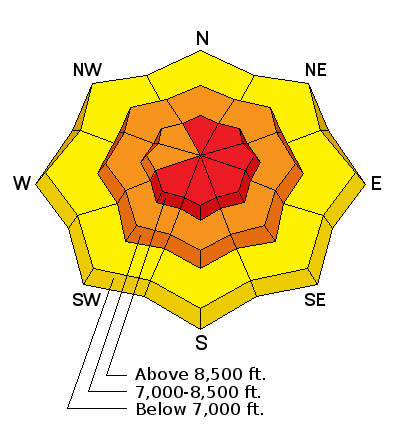
| Advisory: Ogden Area Mountains | Issued by Mark Staples for Saturday - January 16, 2016 - 7:44am |
|---|

|
bottom line Today the avalanche danger will be rising. On upper elevation, wind loaded slopes the avalanche danger will become HIGH. As winds load slopes human triggered avalanches will be likely and there should be some natural avalanches as well. Human triggered avalanches will also be likely on mid elevation slopes which have a CONSIDERABLE avalanche danger, especially ones shaded from the sun where the new snow rests on weak facets.
|
 |
avalanche watch THE FOREST SERVICE UTAH AVALANCHE CENTER IN SALT LAKE CITY HAS ISSUED A BACKCOUNTRY AVALANCHE WATCH * TIMING…IN EFFECT FROM 6 AM MST THIS MORNING TO 6 AM MST SUNDAY * AFFECTED AREA…ALL THE MOUNTAINS OF NORTHERN AND CENTRAL UTAH AND SOUTHEASTERN IDAHO, TO INCLUDE THE WASATCH RANGE, THE BEAR RIVER RANGE, THE WESTERN UINTA RANGE AND THE MANTI-SKYLINE PLATEAU. * AVALANCHE DANGER…THE AVALANCHE DANGER WILL BE RISING TO HIGH TODAY . * IMPACTS…WIDESPREAD WEAK SNOW EXISTS UNDER NEW SNOW FROM THE LAST 48 HOURS. INCREASING WINDS WILL MAKE NATURAL AND HUMAN TRIGGERED AVALANCHES MORE LIKELY AS THE DAY PROGRESSES. THE AVALANCHE DANGER WILL BE RISING. THIS WARNING DOES NOT APPLY TO SKI AREAS WHERE AVALANCHE HAZARD REDUCTION MEASURES ARE PERFORMED. |
 |
special announcement
|
 |
current conditions This morning temperatures are in the teens F and westerly winds are blowing 10-15 mph gusting to 20-30 mph. During the last 48 hours, 10-13 inches of snow has fallen. |
 |
recent activity Yesterday, two natural avalanches were spotted in the backcountry near Snowbasin, but visibility was poor and we have few details. However, recent avalanche activity is a clear sign of unstable conditions.
|
| type | aspect/elevation | characteristics |
|---|

|
|
LIKELIHOOD
 LIKELY
UNLIKELY
SIZE
 LARGE
SMALL
TREND
 INCREASING DANGER
SAME
DECREASING DANGER
|
|
description
The main story today is that winds will increase and blow from the west and northwest. There is plenty of low density, new snow for them to transport and form fresh wind slabs. These wind slabs will produce avalanches regardless of where you find them. Watch for small cross-loaded terrain features. Because winds will be increasing today, don’t take anything for granted. Conditions will be changing and a slope that seemed stable may become unstable if it is being loaded with wind-blown snow. |
| type | aspect/elevation | characteristics |
|---|

|

|
LIKELIHOOD
 LIKELY
UNLIKELY
SIZE
LARGE
SMALL
TREND
 INCREASING DANGER
SAME
DECREASING DANGER
|
|
description
Slopes facing NW through N through E aspects have weak, faceted snow under the new snow. This faceted snow formed on shaded slopes during recent clear and cold weather. It seems to be the weakest on slopes that avalanche around Christmas; however, this faceted snow was found on the surface early this week even on slopes that did not avalanche and that had a deep snowpack. Trent and I were in Upper Days Fork yesterday near Little Cottonwood Canyon where the new snow didn’t seem like it was cohesive enough to produce an avalanche. However, it doesn’t matter how the new snow feels, what matters is how it compares to the weak layer underneath it. If the new snow has slightly more strength than the facets on which it is resting, then it will act as a slab and can avalanche. In fact there were two recent avalanches in that area illustrating this fact. |
 |
weather Today, temperatures will rise into the high 20s F and winds will be increasing in late morning. This afternoon, winds will be blowing 20 mph and gusting 30-40 mph from the W and NW. More snow will begin falling late this afternoon and bring a few inches by late day and 4-6 inches by tomorrow morning. |
| general announcements Remember your information can save lives. If you see anything we should know about, please participate in the creation of our own community avalanche advisory by submitting snow and avalanche conditions. You can also call us at 801-524-5304, email by clicking HERE, or include #utavy in your tweet or Instagram. To get help in an emergency (to launch a rescue) in the Wasatch, call 911. Be prepared to give your GPS coordinates or the run name. Dispatchers have a copy of the Wasatch Backcountry Ski map. Backcountry Emergencies. It outlines your step-by-step method in the event of a winter backcountry incident. If you trigger an avalanche in the backcountry, but no one is hurt and you do not need assistance, please notify the nearest ski area dispatch to avoid a needless response by rescue teams. Thanks. Salt Lake and Park City – Alta Central (801-742-2033), Canyons Resort/PCMR Dispatch (435)615-1911 Snowbasin Resort Dispatch (801-620-1017), Powder Mountain Dispatch (801-745-3772 x 123). Sundance Dispatch (801-223-4150) EMAIL ADVISORY If you would like to get the daily advisory by email you will need to subscribe here. DAWN PATROL Hotline updated daily by 5-530am - 888-999-4019 option 8. Twitter Updates for your mobile phone - DETAILS UDOT canyon closures: LINK TO UDOT, or on Twitter, follow @UDOTavy, @CanyonAlerts or @AltaCentral Utah Avalanche Center mobile app - Get your advisory on your iPhone along with great navigation and rescue tools. Powderbird Helicopter Skiing - Blog/itinerary for the day Lost or Found something in the backcountry? - http://nolofo.com/ To those skinning uphill at resorts: it is your responsibility to know the resort policy on uphill travel. You can see the uphill travel policy for each resort here. IMPORTANT: Before skinning or hiking at a resort under new snow conditions, check in with Ski Patrol. Resorts can restrict or cut off access if incompatible with control and grooming operations. Benefit the Utah Avalanche Center when you shop from Backcountry.com or REI: Click this link for Backcountry.com or this link to REI, shop, and they will donate a percent of your purchase price to the UAC. Both offer free shipping (with some conditions) so this costs you nothing! Benefit the Utah Avalanche Center when you buy or sell on ebay - set the Utah Avalanche Center as a favorite non-profit in your ebay account here and click on ebay gives when you buy or sell. You can choose to have your seller fees donated to the UAC, which doesn't cost you a penny. This information does not apply to developed ski areas or highways where avalanche control is normally done. This advisory is from the U.S.D.A. Forest Service, which is solely responsible for its content. This advisory describes general avalanche conditions and local variations always exist. |


