| Please join us at the 23rd annual Black Diamond Fall Fundraiser Party Thursday Sept 15. Tickets are on sale now here, at the Black Diamond store & at REI. Special bonus raffle for online ticket purchasers! |
| Please join us at the 23rd annual Black Diamond Fall Fundraiser Party Thursday Sept 15. Tickets are on sale now here, at the Black Diamond store & at REI. Special bonus raffle for online ticket purchasers! |
| Advisory: Ogden Area Mountains | Issued by Evelyn Lees for Friday - January 15, 2016 - 7:23am |
|---|

|
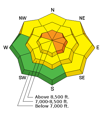
bottom line The Avalanche Danger is CONSIDERABLE on steep, wind-drifted slopes facing northwest through easterly at the upper elevations, above about 9,500’. Avoid travel on and below wind-drifted slopes, where avalanches can be triggered remotely. Other steep slopes have a MODERATE danger, and small loose sluffs will be easy to trigger on all aspects.
|
 |
special announcement
|
 |
current conditions Light to moderate snow is falling in the mountains this morning, and the Ogden area mountains picked up another 2 to 3" overnight. Winds are from the southwest, slowly shifting to the west, and averaging 10 to 15 mph. Speeds across the high ridge lines have been averaging 25 to 35 mph most of the night. Temperatures have warmed into the teens and low 20s.
Storm totals since midweek are now in the 6 to 8” range, with 8 to 14” in the Cottonwoods. It’s an excellent little refresher, nicely filling in old tracks. |
 |
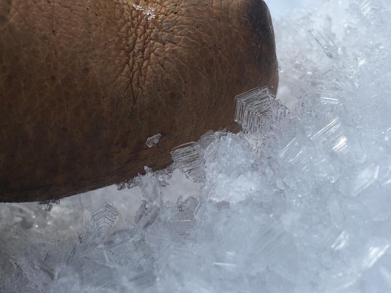
recent activity Yesterday in the backcountry, small sluffs and wind slabs were easily triggered in the Salt Lake and Park City mountains. Ogden area resorts also reported easily triggered wind slabs in the wind affected, ridge line terrain, large enough to catch and carry a person, with a few large enough to bury a person. They were on shady slopes, failing on the weak, faceted old snow surface. Recent Ogden area observations:
Left: Weak surface snow, including surface hoar Doug Wewer photo Right: wind drifting snow, Chris Morgan
|
| type | aspect/elevation | characteristics |
|---|

|
|
LIKELIHOOD
 LIKELY
UNLIKELY
SIZE
 LARGE
SMALL
TREND
 INCREASING DANGER
SAME
DECREASING DANGER
|
|
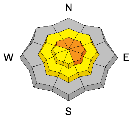
description
We finished off the high pressure with a layer of weak, faceted snow on the shady slopes, and have been slowly loading it with new snow. The numerous great observations from the Ogden area mountains have talked about how weak and widespread this snow layer is, including at the lower elevations, and including some surface hoar that has probably been preserved.
Today, I think we will finally have a stiff enough slab in wind-affected terrain for avalanches to be easily triggered, and even a few natural slides to occur if the winds increase as forecast. On many slopes, the weakest old snow is in shallow snowpack areas, including slopes that slid early this winter. Slides can be remotely triggered from a distance today, pull back further than expected along the ridgelines, and run longer than average distances, entraining snow as they move down the hill. These slides will be large enough to bury a person.
Avalanche accidents often occur during periods of increasing danger. Winds are forecast to increase this afternoon, so be observant and ready to switch to wind sheltered terrain if speeds pick up where you are. |
| type | aspect/elevation | characteristics |
|---|

|
|
LIKELIHOOD
LIKELY
UNLIKELY
SIZE
 LARGE
SMALL
TREND
INCREASING DANGER
SAME
DECREASING DANGER
|
|
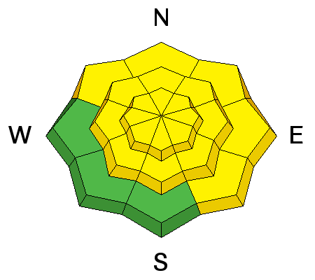
description
Even out of the wind-affected terrain, expect to trigger loose snow sluffs and small soft slabs on steep slopes of all aspects, including the sunny slopes. These will be new snow only, but still large enough to catch and carry a person. I still have thoughts about the deeper weak layers in the snowpack, but think today’s activity will be new snow only. |
 |
weather The small storm scooting through northern Utah this morning could drop another 2 to 5 inches of snow before it tapers off midday. Ridge line temperatures will cool into the low teens by afternoon. The winds are slowly shifting to a more northwesterly direction, and may increase slightly, into the 20-25 mph range along the high ridge lines. There will be a break in the snowfall this afternoon through Saturday morning, followed by a small, warmer, windier storm Saturday evening into Sunday. |
general announcements
|