| Please join us at the 23rd annual Black Diamond Fall Fundraiser Party Thursday Sept 15. Tickets are on sale now here, at the Black Diamond store & at REI. Special bonus raffle for online ticket purchasers! |
| Please join us at the 23rd annual Black Diamond Fall Fundraiser Party Thursday Sept 15. Tickets are on sale now here, at the Black Diamond store & at REI. Special bonus raffle for online ticket purchasers! |
| Advisory: Ogden Area Mountains | Issued by Drew Hardesty for Monday - January 4, 2016 - 7:22am |
|---|

|
bottom line A MODERATE danger exists in the backcountry for Friday's lingering wind drifts as well as for human triggered deep slab avalanches. The danger is most pronounced on mid and upper elevation west to north to easterly facing slopes above about 8000'. Excellent and safe soft settled powder may still be found in the wind sheltered northerly terrain below treeline on 30° slopes or less - and not connected to anything steeper above or adjacent to you. Many folks these days think that Moderate is the new Low. It's not the case - it couldn't be further from the truth.
|
 |
special announcement
Wednesday, Jan 6th – Join us at 7 pm for a showing of the award winning film Meru at Brewvies to benefit the Utah Avalanche Center. For details and advance purchase discount tickets, go here. |
 |
current conditions As of 5am, skies are clear to partly cloudy. Expect clouds to stream in from the south over the course of the day. We're finally out of the icebox, as mountain temperatures rose into the 40s yesterday at 8000' and reached just above freezing along the 9500' ridgelines yesterday. Morning temps are now in the mid to upper 20s. South to southeast winds along the unobstructed ridgelines spinning at 25-30mph. Total snow depths across the range are 40-50" in the Cottonwoods, 35-45" along the Park City ridgeline, 35-45" in the Ogden area mountains, and 50-60" in the Provo area mountains. These depths, of course, describe areas that didn't avalanche to the ground during the Christmas avalanche cycle and weren't scoured to the ground from the New Year's southeast wind event. (photo - Wewer) Total snow and water from December from our UDOT colleagues at the Alta Guard station (continuous records since 44/45) are 105"/7.7" with combined November/December total of 151"/11.8". We're roughly 93% of average for snowfall. Month by month snow and water totals since the waning days of World War II can be found here. Current snotel sites come in at 85-115% of average for snow-water-equivalent for the year.
|
 |
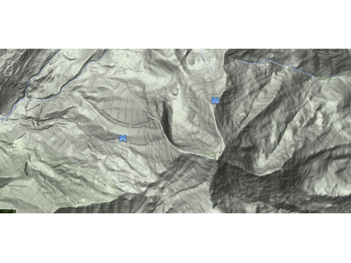
recent activity We heard of no activity from the backcountry yesterday with no reports of cracking or collapsing within the weekend's tender snowpack. That being said, it's worth taking a look at two separate events on Box Elder peak (one of the gems of Provo) from Friday. What had been a fairly stable snowpack came crashing down with the southeasterly winds on New Year's, leading to a total of five people caught, two carried, two partial burials, and lost gear. The two parties - one on the west flank of Box Elder at 8700' and the other tiptoe-ing into just the edge of the upper reaches of the east Shotgun Chute on the north flank at 10,300' - consisted of very experienced backcountry skiers and fortunately came away mostly unscathed. Many thanks for their reports and photos. Photo below of locations of involvements and partially buried skier in the east Shotgun Chute. Avalanche airbag deployed.
|
| type | aspect/elevation | characteristics |
|---|

|

|
LIKELIHOOD
 LIKELY
UNLIKELY
SIZE
 LARGE
SMALL
TREND
 INCREASING DANGER
SAME
DECREASING DANGER
|
|
description
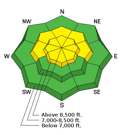
The most recent human triggered Deep Slab avalanche occurred in the backcountry near Murdock Peak on Saturday. One of our observers walking the ridgeline remotely triggered the 4-5' deep avalanche as it ripped out to the ground. He described the avalanche as "loud" and said that the "branch snapping added a nice effect." Human triggered Deep Slabs remain possible on west to north to easterly facing terrain at the mid and upper elevations and most pronounced on north to northeast facing slopes above about 8000'. Thinner snowpack areas in steep, rocky terrain - particularly along the Park City ridgeline, upper Mill Creek, the Uintas, and the Plateau - seem most suspect. At this stage of the game, immediate and obvious warning signs are typically absent, snow tests yield conflicting results, and we can go days without rumor of trouble in the basement. Ski cuts and other tracks on the slope are virtually meaningless. Typical triggers may include multiple snowmachines on a slope, a large cornice fall, another avalanche cascading down from above, or perhaps another significant weather event. General characteristics of Deep Slabs can be found below. For more info comparing and contrasting the 8 Avalanche Problems, check out our Avalanche Problem Toolbox.
|
| type | aspect/elevation | characteristics |
|---|

|
|
LIKELIHOOD
LIKELY
UNLIKELY
SIZE
 LARGE
SMALL
TREND
 INCREASING DANGER
SAME
DECREASING DANGER
|
|
description
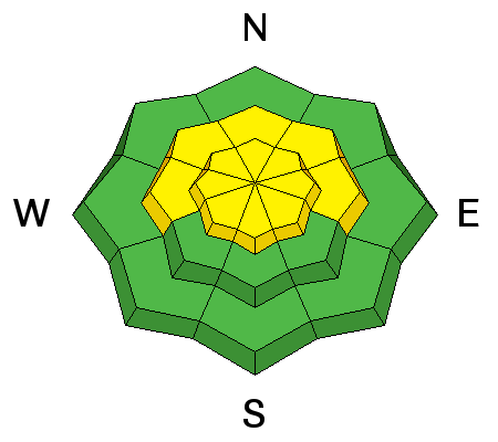
I'd consider the remnant wind slabs from Friday and Saturday isolated, pockety, and scattered across the landscape. Cross-loaded and terrain-channeled drifts may be found in the lee of spines and sub-ridges and beyond convexities well down slope. These generally hard wind whales are to be avoided, particularly above no fall or high consequence terrain. Friday and Saturday's drifts landed on patchwork weak surface snow, significantly contributing to their - as the Canadians say - touchiness. I suspect most of these are welded in by now, but I'd give them another day to settle down.
|
 |
weather We'll have moisture streaming in in the form of clouds today arriving on a southerly flow. Expect a touch of precipitation perhaps in the late hours with a better chance of snowfall later Tues-Wed-Thursday with totals of 6-12", favoring areas on a southwest flow. Mountain temps today will be in the upper 20s to low 30s. Southerly winds will blow 15-20mph. |
| general announcements Remember your information can save lives. If you see anything we should know about, please participate in the creation of our own community avalanche advisory by submitting snow and avalanche conditions. You can also call us at 801-524-5304, email by clicking HERE, or include #utavy in your tweet or Instagram. To get help in an emergency (to launch a rescue) in the Wasatch, call 911. Be prepared to give your GPS coordinates or the run name. Dispatchers have a copy of the Wasatch Backcountry Ski map. Backcountry Emergencies. It outlines your step-by-step method in the event of a winter backcountry incident. If you trigger an avalanche in the backcountry, but no one is hurt and you do not need assistance, please notify the nearest ski area dispatch to avoid a needless response by rescue teams. Thanks. Salt Lake and Park City – Alta Central (801-742-2033), Canyons Resort/PCMR Dispatch (435)615-1911 Snowbasin Resort Dispatch (801-620-1017), Powder Mountain Dispatch (801-745-3772 x 123). Sundance Dispatch (801-223-4150) EMAIL ADVISORY If you would like to get the daily advisory by email you will need to subscribe here. DAWN PATROL Hotline updated daily by 5-530am - 888-999-4019 option 8. Twitter Updates for your mobile phone - DETAILS UDOT canyon closures: LINK TO UDOT, or on Twitter, follow @UDOTavy, @CanyonAlerts or @AltaCentral Utah Avalanche Center mobile app - Get your advisory on your iPhone along with great navigation and rescue tools. Powderbird Helicopter Skiing - Blog/itinerary for the day Lost or Found something in the backcountry? - http://nolofo.com/ To those skinning uphill at resorts: it is your responsibility to know the resort policy on uphill travel. You can see the uphill travel policy for each resort here. IMPORTANT: Before skinning or hiking at a resort under new snow conditions, check in with Ski Patrol. Resorts can restrict or cut off access if incompatible with control and grooming operations. Benefit the Utah Avalanche Center when you shop from Backcountry.com or REI: Click this link for Backcountry.com or this link to REI, shop, and they will donate a percent of your purchase price to the UAC. Both offer free shipping (with some conditions) so this costs you nothing! Benefit the Utah Avalanche Center when you buy or sell on ebay - set the Utah Avalanche Center as a favorite non-profit in your ebay account here and click on ebay gives when you buy or sell. You can choose to have your seller fees donated to the UAC, which doesn't cost you a penny. This information does not apply to developed ski areas or highways where avalanche control is normally done. This advisory is from the U.S.D.A. Forest Service, which is solely responsible for its content. This advisory describes general avalanche conditions and local variations always exist. |