| Please join us at the 23rd annual Black Diamond Fall Fundraiser Party Thursday Sept 15. Tickets are on sale now here, at the Black Diamond store & at REI. Special bonus raffle for online ticket purchasers! |
| Please join us at the 23rd annual Black Diamond Fall Fundraiser Party Thursday Sept 15. Tickets are on sale now here, at the Black Diamond store & at REI. Special bonus raffle for online ticket purchasers! |
| Advisory: Ogden Area Mountains | Issued by Mark Staples for Sunday - January 3, 2016 - 7:19am |
|---|


|
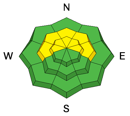
bottom line The avalanche danger is CONSIDERABLE today at upper elevation, wind-loaded slopes mainly facing E, N, and W where triggering a fresh wind slab or drift is likely and triggering a deep slab avalanche remains possible. The avalanche danger is MODERATE at middle elevations where triggering a wind slab or a deep slab avalanche is possible. Go to low elevation, wind sheltered slopes for a LOW avalanche danger.
|
 |
special announcement WEBSITE ISSUES: A DDoS (distributed denial of service) attack has crippled the server in Atlanta that hosts our website. Thank you for your patience. We hope to have the problem resolved ASAP. Until then we’ll post as much information as possible to Facebook, Twitter, Instagram, and the old-fashioned recorded hotline 888-999-4019 Tuesday, Jan 5th - Whole Foods Market in Cottonwood Heights has invited us back to participate in 5% Day, where for one day they donate 5% of the net sales to the Utah Avalanche Center. We will also be in the store from noon until 6:00 pm answering questions and spreading the winter stoke! More information here. Wednesday, Jan 6th – Join us at 7 pm for a showing of the award winning film Meru at Brewvies to benefit the Utah Avalanche Center. For details and advance purchase discount tickets, go here |
 |
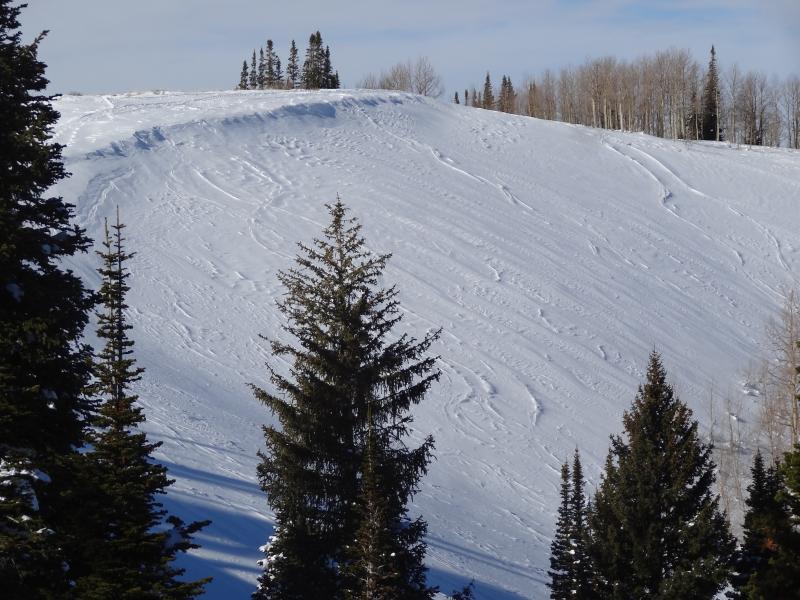
current conditions Cloud cover last night kept things warm with temperatures this morning in the mid to upper 20s F. With an inversion in place, lower parts of the canyons have temperatures in the teens F. Winds were blowing 10-15 mph gusting to 25 mph generally from the S. Many S and SE facing slopes have been scoured and slopes on other aspects have been loaded with stiff wind slabs. Wind sheltered terrain still has good riding because the snow surface faceted during recent clear and cold weather. Scoured slope along Park City Ridgeline (J. Hutchinson)
|
 |
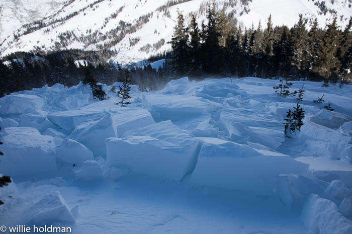
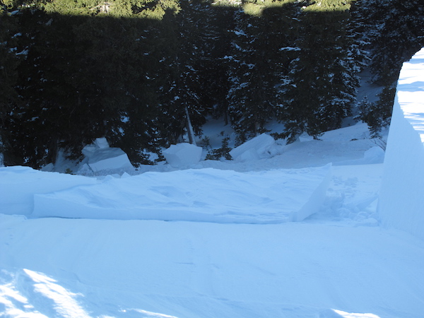
recent activity We’ve had limited access to our observations page. However, there were many wind slab avalanches both Friday and Saturday following Friday’s strong SE winds. Some were triggered naturally while some were triggered by skiers. Two separate groups were surprised and caught in two separate wind slab avalanches on Box Elder Peak near Provo. There have been 2 larger avalanches worth noting. One occurred on Friday in Little Cottonwood Canyon on a N aspect. It was a repeater, having released previously on 12/23. It broke at the ground again, this time 2-3 feet deep. The other on Saturday was on Murdock Peak at the head of Mill Creek on a NE aspect. It had not released previously and broke 3-4 feet deep. The observer who triggered this slide said it started with a fresh wind slab then stepped down breaking near the ground. Photo of 2' wind slab near Box Elder Peak (W. Holdman)
Photo of 3-4' deep avalanche on Murdock Peak (P. Daugherty)
|
| type | aspect/elevation | characteristics |
|---|

|
|
LIKELIHOOD
 LIKELY
UNLIKELY
SIZE
 LARGE
SMALL
TREND
 INCREASING DANGER
SAME
DECREASING DANGER
|
|
description
Wind slabs are the main issue formed by strong S and SE winds mostly on Friday. Look for cross loading on E and W facing slopes and top loading on N facing slopes. There have been many great observations and reports of recent activity involving these wind slabs. Many were triggered by skiers and many occurred naturally. If our website starts working again, check our observations page for the full list. The bad news is that many of these wind slabs rest on small facets that formed on the snow surface during recent clear, cold weather. For this reason these wind slabs will remain unstable longer than normal. The good news is wind sheltered terrain has great snow quality for riding because the snow surface became weak and faceted. The glass is half full right?
|
| type | aspect/elevation | characteristics |
|---|

|
|
LIKELIHOOD
 LIKELY
UNLIKELY
SIZE
 LARGE
SMALL
TREND
INCREASING DANGER
SAME
DECREASING DANGER
|
|
description
The thing about deep slab avalanche problems is that they don’t go away for a long time. In many places with deep snow, facets at the ground are adjusting to the load on top of them and are slowly beginning to heal. In other places they remain weak and the extra weight of wind-blown snow has pushed them a little closer to their breaking point. A good example comes from two observations yesterday. One observer triggered a large avalanche at the ground on a wind loaded slope on a NE aspect on Murdock Peak (full ob here). Only 3/4 of a mile away on an E aspect, an avalanche professional found a snowpack where facets at the ground had gained significant strength (full ob here). So, there you have it, the problem is still lurking. The best places to trigger one of these avalanches are northerly aspects above 9500 feet with the extra weight of wind deposited snow. |
 |
weather Clouds today will limit daytime heating some and high temperatures will climb into the low to mid 30s F. Winds will continue from the S blowing 10-20 mph. Unfortunately cloudy skies won’t bring any snow. The jet stream has split and is sending precipitation north to Alaska and south to the southwestern U.S. Snowfall could start in southern Utah Monday night. I’d be watching the weather and considering a drive to Moab later this week where snow conditions are as good as they’ve been in a very long time. |
| general announcements Remember your information can save lives. If you see anything we should know about, please participate in the creation of our own community avalanche advisory by submitting snow and avalanche conditions. You can also call us at 801-524-5304, email by clicking HERE, or include #utavy in your tweet or Instagram. To get help in an emergency (to launch a rescue) in the Wasatch, call 911. Be prepared to give your GPS coordinates or the run name. Dispatchers have a copy of the Wasatch Backcountry Ski map. Backcountry Emergencies. It outlines your step-by-step method in the event of a winter backcountry incident. If you trigger an avalanche in the backcountry, but no one is hurt and you do not need assistance, please notify the nearest ski area dispatch to avoid a needless response by rescue teams. Thanks. Salt Lake and Park City – Alta Central (801-742-2033), Canyons Resort/PCMR Dispatch (435)615-1911 Snowbasin Resort Dispatch (801-620-1017), Powder Mountain Dispatch (801-745-3772 x 123). Sundance Dispatch (801-223-4150) EMAIL ADVISORY If you would like to get the daily advisory by email you will need to subscribe here. DAWN PATROL Hotline updated daily by 5-530am - 888-999-4019 option 8. Twitter Updates for your mobile phone - DETAILS UDOT canyon closures: LINK TO UDOT, or on Twitter, follow @UDOTavy, @CanyonAlerts or @AltaCentral Utah Avalanche Center mobile app - Get your advisory on your iPhone along with great navigation and rescue tools. Powderbird Helicopter Skiing - Blog/itinerary for the day Lost or Found something in the backcountry? - http://nolofo.com/ To those skinning uphill at resorts: it is your responsibility to know the resort policy on uphill travel. You can see the uphill travel policy for each resort here. IMPORTANT: Before skinning or hiking at a resort under new snow conditions, check in with Ski Patrol. Resorts can restrict or cut off access if incompatible with control and grooming operations. Benefit the Utah Avalanche Center when you shop from Backcountry.com or REI: Click this link for Backcountry.com or this link to REI, shop, and they will donate a percent of your purchase price to the UAC. Both offer free shipping (with some conditions) so this costs you nothing! Benefit the Utah Avalanche Center when you buy or sell on ebay - set the Utah Avalanche Center as a favorite non-profit in your ebay account here and click on ebay gives when you buy or sell. You can choose to have your seller fees donated to the UAC, which doesn't cost you a penny. This information does not apply to developed ski areas or highways where avalanche control is normally done. This advisory is from the U.S.D.A. Forest Service, which is solely responsible for its content. This advisory describes general avalanche conditions and local variations always exist. |