| Please join us at the 23rd annual Black Diamond Fall Fundraiser Party Thursday Sept 15. Tickets are on sale now here, at the Black Diamond store & at REI. Special bonus raffle for online ticket purchasers! |  |

| Please join us at the 23rd annual Black Diamond Fall Fundraiser Party Thursday Sept 15. Tickets are on sale now here, at the Black Diamond store & at REI. Special bonus raffle for online ticket purchasers! |  |
| Advisory: Ogden Area Mountains | Issued by Evelyn Lees for Friday - January 1, 2016 - 6:58am |
|---|
 |
special announcement Tuesday, Jan 5th - Whole Foods Market in Cottonwood Heights has invited us back to participate in 5% Day, where for one day they donate 5% of the net sales to the Utah Avalanche Center. We will also be in the store from noon until 6:00 pm answering questions and spreading the winter stoke! More information here.
Wednesday, Jan 6th – Join us at 7 pm for a showing of the award winning film Meru at Brewvies to benefit the Utah Avalanche Center. For details and advance purchase discount tickets, go here. |
 |
current conditions Under clear skies, temperatures range from about zero into the single digits in the Ogden area mountains this morning. The winds are a slight spoiler though – they are blowing anywhere from northeasterly to southeasterly, depending on the exact location, and they’re averaging 20 to 25 mph across the peaks and high ridge lines, and gusting to 30 mph in a few locations. Highest speeds were overnight, and they have decreased a bit in the past hour. Snow quality remains excellent on most aspects, with powder over a supportable base. |
 |
recent activity No new avalanches were reported from the backcountry yesterday, but visibility over the past week has confirmed the widespread avalanche activity from around December 21 - 23rd. |
| type | aspect/elevation | characteristics |
|---|


|


|

LIKELIHOOD
 LIKELY
UNLIKELY
SIZE
 LARGE
SMALL
TREND
 INCREASING DANGER
SAME
DECREASING DANGER
|
|
description
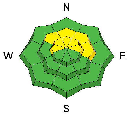
The facets on the ground are strengthening in some areas, but they remain weak, loose and sugary in others. Capped with a strong slab, triggering one of these slides is getting harder and harder and the chance more isolated, but if you do trigger one, it will still break near the ground. Slopes steeper than about 35 degrees facing west through north through east that did not slide last week continue to be suspect - especially in shallower snowpack areas and rocky terrain. Low angle terrain and slopes that have avalanched are safer. Some slopes that have slid are obvious, others not so much. Look at the slopes that slid in the photos below in the SL mountains. Left is Wolverine Cirque, Kirkkert photo; Right is Mark White photo, observation HERE
|
| type | aspect/elevation | characteristics |
|---|


|


|

LIKELIHOOD
 LIKELY
UNLIKELY
SIZE
 LARGE
SMALL
TREND
 INCREASING DANGER
SAME
DECREASING DANGER
|
|
description
The northeasterly to southeasterly winds are blowing and drifting the light density snow - loading it both on and off the ridge lines. Avoid these soft cracky drifts, which are most widespread on slopes facing the west 1/2 of the compass.
In addition, you may be able to trigger a few loose snow sluffs in the weakening surface snow. |
 |
weather Under clear skies and lots of sunshine, a slow warming trend will allow ridge line temperatures to warm into the mid teens today. The southeasterly winds will continue to blow along the ridge lines in the 15 to 25 mph range, slowly decreasing through out the day. A switch to a southwesterly flow Saturday and Sunday will bring increasing clouds and winds, with temperatures warming into the mid 20s to low 30s. |
general announcements
|
Advisory Hotline: (888) 999-4019 | Contact Information