| Please join us at the 23rd annual Black Diamond Fall Fundraiser Party Thursday Sept 15. Tickets are on sale now here, at the Black Diamond store & at REI. Special bonus raffle for online ticket purchasers! |
| Please join us at the 23rd annual Black Diamond Fall Fundraiser Party Thursday Sept 15. Tickets are on sale now here, at the Black Diamond store & at REI. Special bonus raffle for online ticket purchasers! |
| Advisory: Ogden Area Mountains | Issued by Mark Staples for Monday - December 28, 2015 - 7:24am |
|---|


|
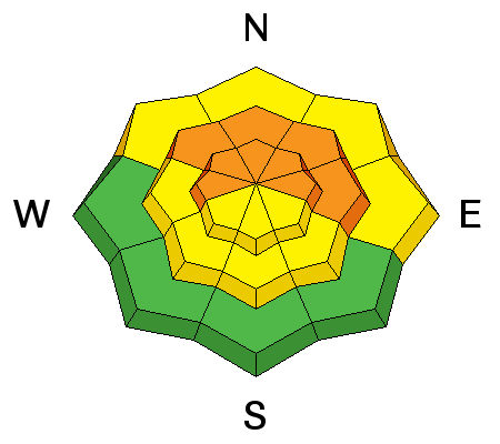
bottom line Today the avalanche danger is CONSIDERABLE on slopes above 7000 feet generally on the northern half of compass including those facing east. Human triggered avalanches 3-5 feet deep are likely and the consequences will be deadly. The avalanche danger is lower on slopes at lower elevations on southerly aspects. Remember - if you step outside the exit gates from a mountain resort, your are entering dangerous avalanche conditions.
|
 |
special announcement If you're heading to the resorts, support the UAC and get your lift tickets here - Details here |
 |
current conditions It's another cold morning with uniform temperatures throughout the mountains in the low teens F. Winds this morning were blowing 5-10 mph mostly from the SW with gust of 15 mph. Sunshine yesterday warmed south facing slopes enough to melt the snow surface a bit which should have a crust this morning. Skies remained cold and clear which may have kept the highest elevation south aspects dry. Most slopes on the northern half of the compass still have great powder. Last week's storms dramatically changed snow coverage throughout the Wasatch Mountains with settled snow depths of 4-5 feet.
|
 |
recent activity Many avalanches occurred last week around Christmas. The most notable recent avalanche occurred on Saturday in the backcountry near Alta at Rocky Point on a steep East-facing aspect at 10,400'. It was triggered remotely from 300' away and the crown was 4'-5' in places, failing on faceted snow at the ground. Read the report here. Trent visited this avalanche yesterday and posted more photos and a video here. Another large slide breaking at the ground was triggered with explosives on Saturday at one of the Cottonwood resorts on a high eleveation, south facing slope. A large, remotely triggered slide also occurred in the Unita Mountains yesterday (read here) where the snowpack is similar to the one in the Wasatch Range. Remotely triggered avalanches are major red flags that shouldn't be ignored. |
| type | aspect/elevation | characteristics |
|---|

|
|
LIKELIHOOD
 LIKELY
UNLIKELY
SIZE
 LARGE
SMALL
TREND
 INCREASING DANGER
SAME
DECREASING DANGER
|
|
description
Deep slab avalanches are defined as being:
Another difficulty with this avalanche problem is that signs of instability are either not obvious or potentially don't exist. Our only clue to this problem is knowing that it exists. Ski cuts and cornice drops are not effective, and ski tracks on a slope only provide a false sense of slope stability. Many avalanche accidents involving deep slabs occur when the 3rd, 5th, or even 10th person gets on the slope. Triggering a deep slab avalanche is most likely on the northerly facing and east facing slopes like the one in the photo below from Mineral Fork in Big Cottonwood Canyon.
Triggering a large avalanche can easily happen in terrain that appears less scary like the terrain near Rocky point where Saturday's remotely triggered avalanche occurred.
A regular observer (Kikkert) put it best "Danger rating will gradually decrease from considerable to a scary moderate, but its all the same to me, with patience the key for a while yet." Dealing with avalanches like these is tough because we don't know what the exact odds of triggering one is. However, we know that they will be large and deadly and this fact should make our decision making easy - stick to low angle slopes. Triggering a large, deep slab avalanche is less likely but still definitely possible on south aspects. Unfortunately snow quality on these aspects may push us around the compass chasing better snow and cause us to start riding lines closer to where this problem is more likely.
|
| type | aspect/elevation | characteristics |
|---|

|
|
LIKELIHOOD
 LIKELY
UNLIKELY
SIZE
 LARGE
SMALL
TREND
 INCREASING DANGER
SAME
DECREASING DANGER
|
|
description
Remember - If you avoid avalanche terrain, you can avoid avalanches. If you don't know how to identify avalanche terrain consider taking an avalanche class. Click here for a list of Utah Avalanche Center classes and here for classes offered by other providers. Safe and stellar 5-star powder can be found on slopes less steep than 30 degrees with nothing steeper above. Watch the video below for an introduction to terrain selection
|
 |
weather A cold air mass and some high level clouds should keep temperatures from rising much today and high temperatures should be near 20 degrees F. Winds will continue from the SW blowing 5-10 mph gusting 15-20 mph. The mountains could get a dusting of snow tonight. Over the next few days, winds should remain light, temperatures should stay cool, and several inches of snow should fall. All of this means riding conditions should remain excellent. |
| general announcements Remember your information can save lives. If you see anything we should know about, please participate in the creation of our own community avalanche advisory by submitting snow and avalanche conditions. You can also call us at 801-524-5304, email by clicking HERE, or include #utavy in your tweet or Instagram. To get help in an emergency (to launch a rescue) in the Wasatch, call 911. Be prepared to give your GPS coordinates or the run name. Dispatchers have a copy of the Wasatch Backcountry Ski map. Backcountry Emergencies. It outlines your step-by-step method in the event of a winter backcountry incident. If you trigger an avalanche in the backcountry, but no one is hurt and you do not need assistance, please notify the nearest ski area dispatch to avoid a needless response by rescue teams. Thanks. Salt Lake and Park City – Alta Central (801-742-2033), Canyons Resort/PCMR Dispatch (435)615-1911 Snowbasin Resort Dispatch (801-620-1017), Powder Mountain Dispatch (801-745-3772 x 123). Sundance Dispatch (801-223-4150) EMAIL ADVISORY If you would like to get the daily advisory by email you will need to subscribe here. DAWN PATROL Hotline updated daily by 5-530am - 888-999-4019 option 8. Twitter Updates for your mobile phone - DETAILS UDOT canyon closures: LINK TO UDOT, or on Twitter, follow @UDOTavy, @CanyonAlerts or @AltaCentral Utah Avalanche Center mobile app - Get your advisory on your iPhone along with great navigation and rescue tools. Powderbird Helicopter Skiing - Blog/itinerary for the day Lost or Found something in the backcountry? - http://nolofo.com/ To those skinning uphill at resorts: it is your responsibility to know the resort policy on uphill travel. You can see the uphill travel policy for each resort here. IMPORTANT: Before skinning or hiking at a resort under new snow conditions, check in with Ski Patrol. Resorts can restrict or cut off access if incompatible with control and grooming operations. Benefit the Utah Avalanche Center when you shop from Backcountry.com or REI: Click this link for Backcountry.com or this link to REI, shop, and they will donate a percent of your purchase price to the UAC. Both offer free shipping (with some conditions) so this costs you nothing! Benefit the Utah Avalanche Center when you buy or sell on ebay - set the Utah Avalanche Center as a favorite non-profit in your ebay account here and click on ebay gives when you buy or sell. You can choose to have your seller fees donated to the UAC, which doesn't cost you a penny. This information does not apply to developed ski areas or highways where avalanche control is normally done. This advisory is from the U.S.D.A. Forest Service, which is solely responsible for its content. This advisory describes general avalanche conditions and local variations always exist. |


