| Please join us at the 23rd annual Black Diamond Fall Fundraiser Party Thursday Sept 15. Tickets are on sale now here, at the Black Diamond store & at REI. Special bonus raffle for online ticket purchasers! |
| Please join us at the 23rd annual Black Diamond Fall Fundraiser Party Thursday Sept 15. Tickets are on sale now here, at the Black Diamond store & at REI. Special bonus raffle for online ticket purchasers! |
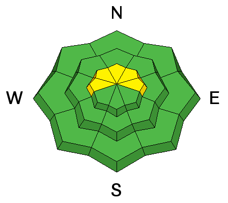
| Advisory: Ogden Area Mountains | Issued by Drew Hardesty for Saturday - December 19, 2015 - 7:23am |
|---|

|
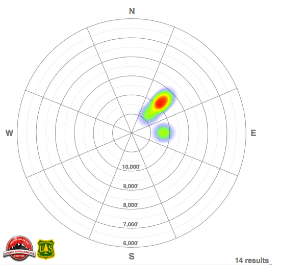
bottom line Most terrain has an overall MODERATE danger. A CONSIDERABLE danger, however, persists in the upper elevation northwest to north to east facing terrain where human triggered slides up to 2-3' deep remain possible. The danger may be more pronounced along the Park City ridgeline and in the mountains along the BCC/Mill Creek crest. Collapsing and shooting cracks are immediate signs of instability. New wind drifts along the high northerly terrain and wet sluffs and roof-slides round out today's concerns.
|
 |
special announcement Heading to the resorts today? Buy discount lift tickets to Utah resorts and benefit the Utah Avalanche Center! Details here
We've just produced a page called Backcountry Emergencies. It outlines your step-by-step method in the event of a winter backcountry incident. |
 |
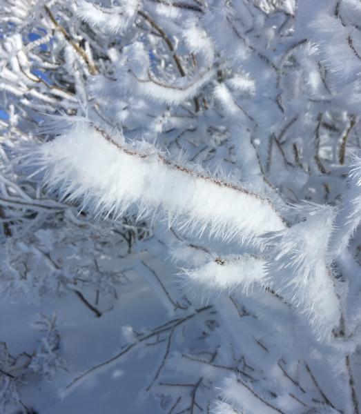
current conditions Skies are partly cloudy with high and mid-level clouds..Ahead of the approaching (albeit splitting storm), the southerly winds ramped up overnight and are blowing 30-40mph with gusts into the 50s and 60s. Temps continue their upward march with overnight lows in the upper 20s to low 30s. A rime/freezing rain event early Friday morning capped what was 5 star skiing and riding conditions, and my quick clip below demonstrates the snow conditions on all aspects and elevations up to and over 10,000'. I toured in the Ogden area mountains yesterday and while the coverage remains quite thin at the mid and low elevations (1-2'), the breakable crust helped to slow me down through the luge-like exit to the trailhead. (photos: Gagne, Wilson)
|
 |
recent activity No avalanches went reported from the backcountry in the central Wasatch or Provo area mountains, though the winds were sufficient to pry out a couple hard wind pockets in the high alpine along the Ogden skyline. The new snow wind pockets were estimated to be 12-18" deep and 50' wide, with one pocket 2-2.5' deep. Collapsing in both the new wind drifts and into the old basal facets was still noted along the Park City ridgeline, the wind swept terrain below Wolverine and high along the Cutler Ridge below Ben Lomond. A couple new avalanches from the natural cycle on Thursday filtered in: naturals in both God's Lawnmower of Kessler Peak and a large natural to near the ground off the Cardiac Ridge. The noted naturals are listed here - and one can gauge the pattern of avalanches from Thursday below.
|
| type | aspect/elevation | characteristics |
|---|

|
|
LIKELIHOOD
 LIKELY
UNLIKELY
SIZE
 LARGE
SMALL
TREND
 INCREASING DANGER
SAME
DECREASING DANGER
|
|
description
The basal facets tipped their hand with the winds Wednesday night into Thursday and set the stage for a good number of natural and remotely triggered avalanches. In fact, it really wasn't until the wind started to blow that part of the house fell apart. For today - it won't be as active as Thursday, but my suspicion is that a cornice drop or human weight collapsing the slab onto the weak basal layer - even from the ridgeline or adjacent terrain - may be all it takes to trigger another 3' deep slide to the ground. With collapsing still present, with snow tests still indicating unstable conditions, and with additional rime crust - hampered wind loading last night and today, all bets remain off the table. You can see Kory Davis's snow testing from the Snowbasin backcountry below -
Snowpits Dec 18 from Kory Davis on Vimeo.
|
| type | aspect/elevation | characteristics |
|---|

|
|
LIKELIHOOD
 LIKELY
UNLIKELY
SIZE
LARGE
SMALL
TREND
 INCREASING DANGER
SAME
DECREASING DANGER
|
|
description
I've been fooled before in thinking that a rain/rime crust would cap the snowpack and prevent any wind drifting as yesterday morning's couple hard slab naturals along the Ogden skyline can attest. Soft and hard wind drifts will be more prevalent along the west to north to east facing terrain and may be well off the ridges and potentially cross-loaded into chutes and gullies. These - if triggered - may also step down into older snow 2-3' deep. |
| type | aspect/elevation | characteristics |
|---|

|

|
LIKELIHOOD
LIKELY
UNLIKELY
SIZE
LARGE
SMALL
TREND
 INCREASING DANGER
SAME
DECREASING DANGER
|
|
description
Once the rain/rime crust softens, any direct sun and additional warming will be enough to produce some wet sluffs on both the steep sunny slopes and the low elevation northerly terrain, particularly in terrain sheltered from the wind. Roofs may also begin to shed their load from the week, particularly in the valleys and mountain towns. Utah tragically suffered one roof-a-lanche in January 1995.
|
 |
weather We'll have increasing clouds, continued moderate to strong southerly to southwesterly winds and mountain temps rising to near 30 at 10,000', the low 40s at 8000'. A quick hitting system moves through overnight, dropping temps to the teens at 10,000' while delivering 3-6" of additional snow. The next set of storms look to arrive early Monday through late week. Significant precipitation and strong winds describe the weather. I'll have more info by midday to early afternoon on our mountain weather forecast. Mountain weather info and forecasts for other regions can be found up in the Menu at the top. |
| general announcements Remember your information can save lives. If you see anything we should know about, please participate in the creation of our own community avalanche advisory by submitting snow and avalanche conditions. You can also call us at 801-524-5304, email by clicking HERE, or include #utavy in your tweet or Instagram. To get help in an emergency (to launch a rescue) in the Wasatch, call 911. Be prepared to give your GPS coordinates or the run name. Dispatchers have a copy of the Wasatch Backcountry Ski map. If you trigger an avalanche in the backcountry, but no one is hurt and you do not need assistance, please notify the nearest ski area dispatch to avoid a needless response by rescue teams. Thanks. Salt Lake and Park City – Alta Central (801-742-2033), Canyons Resort/PCMR Dispatch (435)615-1911 Snowbasin Resort Dispatch (801-620-1017), Powder Mountain Dispatch (801-745-3772 x 123). Sundance Dispatch (801-223-4150) EMAIL ADVISORY If you would like to get the daily advisory by email you will need to subscribe here. DAWN PATROL Hotline updated daily by 5-530am - 888-999-4019 option 8. Twitter Updates for your mobile phone - DETAILS UDOT canyon closures: LINK TO UDOT, or on Twitter, follow @UDOTavy, @CanyonAlerts or @AltaCentral Utah Avalanche Center mobile app - Get your advisory on your iPhone along with great navigation and rescue tools. Wasatch Powderbird Guides Blog/Itinerary for the Day. Lost or Found something in the backcountry? - http://nolofo.com/ To those skinning uphill at resorts: it is your responsibility to know the resort policy on uphill travel. You can see the uphill travel policy for each resort here. IMPORTANT: Before skinning or hiking at a resort under new snow conditions, check in with Ski Patrol. Resorts can restrict or cut off access if incompatible with control and grooming operations. Benefit the Utah Avalanche Center when you shop from Backcountry.com or REI: Click this link for Backcountry.com or this link to REI, shop, and they will donate a percent of your purchase price to the UAC. Both offer free shipping (with some conditions) so this costs you nothing! Benefit the Utah Avalanche Center when you buy or sell on ebay - set the Utah Avalanche Center as a favorite non-profit in your ebay account here and click on ebay gives when you buy or sell. You can choose to have your seller fees donated to the UAC, which doesn't cost you a penny. This information does not apply to developed ski areas or highways where avalanche control is normally done. This advisory is from the U.S.D.A. Forest Service, which is solely responsible for its content. This advisory describes general avalanche conditions and local variations always exist. |