| Please join us at the 23rd annual Black Diamond Fall Fundraiser Party Thursday Sept 15. Tickets are on sale now here, at the Black Diamond store & at REI. Special bonus raffle for online ticket purchasers! |
| Please join us at the 23rd annual Black Diamond Fall Fundraiser Party Thursday Sept 15. Tickets are on sale now here, at the Black Diamond store & at REI. Special bonus raffle for online ticket purchasers! |
| Advisory: Ogden Area Mountains | Issued by Mark Staples for Monday - December 14, 2015 - 6:15am |
|---|

|
bottom line There is a HIGH danger on northerly aspects at upper elevations. Today's snowfall has created very dangerous avalanche conditions and travel in avalanche terrain is NOT recommended. With snowfall continuing and winds expected to increase later today, the danger on other slopes could rise to HIGH as well.
|
 |
avalanche warning THE FOREST SERVICE UTAH AVALANCHE CENTER IN SALT LAKE CITY HAS ISSUED A BACKCOUNTRY AVALANCHE WARNING. * TIMING…IN EFFECT FROM 6 AM MST THIS MORNING TO 6 AM MST TUESDAY * AFFECTED AREA…FOR THE MOUNTAINS OF NORTHERN UTAH INCLUDING THE WASATCH RANGE NEAR OGDEN, SALT LAKE CITY AND PROVO. * AVALANCHE DANGER…THE AVALANCHE DANGER FOR THE WARNING AREA WILL BE HIGH TODAY. * IMPACTS…HEAVY SNOWFALL HAS FALLEN ON A WEAK SNOWPACK CREATING WIDESPREAD AREAS OF UNSTABLE SNOW. TRAVEL IN AVALANCHE TERRAIN IS NOT RECOMMENDED. STAY OFF OF AND OUT FROM UNDER SLOPES STEEPER THAN 30 DEGREES. BACKCOUNTRY TRAVELERS SHOULD CONSULT WWW.UTAHAVALANCHECENTER.ORG OR CALL 1-888-999-4019 FOR MORE DETAILED INFORMATION. THIS WARNING DOES NOT APPLY TO SKI AREAS WHERE AVALANCHE HAZARD REDUCTION MEASURES ARE PERFORMED. |
 |
special announcement
Confused on a the difference between an Avalanche Watch and an Avalanche Warning? You're not alone. Simply, an Avalanche Watch implies that we expect dangerous conditions soon...an Avalanche Warning implies that dangerous avalanche conditions currently exist. You can read a touch more on a Blog we put together here - |
 |
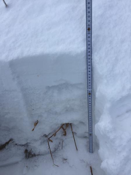
current conditions This morning as of 5 a.m. about 9 inches of snow containing 0.7 inches of water had fallen. South winds last night were blowing 20 mph gusting to 50 mph. As snowfall started at 11 p.m., winds calmed and were blowing 5 mph gusting to 10 mph this morning. Temperatures near 8000 feet were around 25 degrees F. Total snow depths prior to this morning's storm were 1-2 feet. Northerly aspects are either completely weak and faceted or have several layers of facets above and below a stronger layer of snow. Southerly aspects have several ice crusts in the snowpack with weak facets in between them. In the photo below in the backcountry near Snowbasin on a north aspect at 9000 feet, there is 54 cm of snow (about 21 inches) and most of it is faceted. Notice the granular texture of the snow.
|
 |
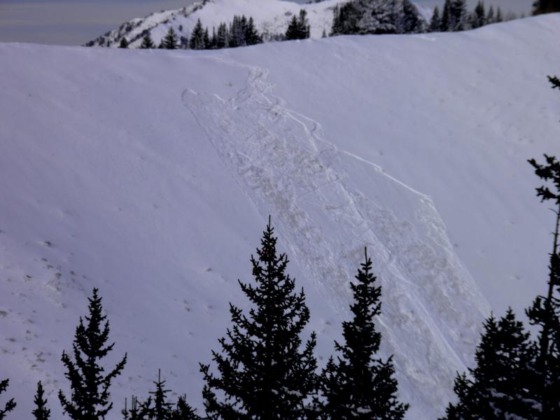
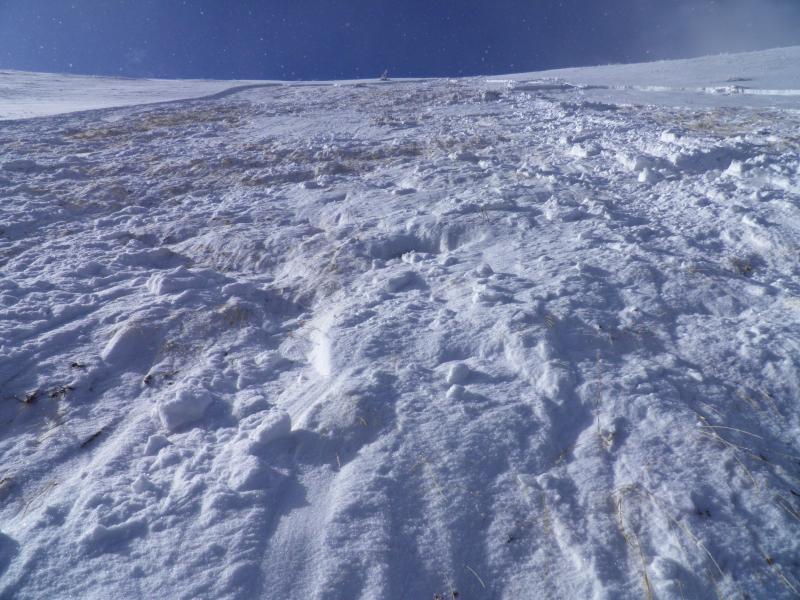
recent activity The snowpack has been pretty quiet; HOWEVER, there have been a few small avalanches giving us a warning. Within the last week, there have been several wind slabs that have fractured on facets and produced small avalanches. Additionally, on Saturday a very experienced backcountry skier unintentionally triggered an 8" deep and 60' wide avalanche in South Monitor bowl along the Park City ridgeline. The slide - mostly east facing at 9800' - collapsed a couple crusts, running on early December faceted snow and broke 30' above him after his fourth turn on the slope. The slide eventually stepped down to the ground as it ran down toward the flats below. Fortunately, he was not caught or carried, only surprised. You can read more about the close call here.
Photo: M. White
Photo: M. White
|
| type | aspect/elevation | characteristics |
|---|

|
|
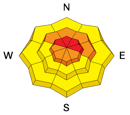
LIKELIHOOD
 LIKELY
UNLIKELY
SIZE
 LARGE
SMALL
TREND
 INCREASING DANGER
SAME
DECREASING DANGER
|
|
description
Today will have dangerous avalanche conditions, and I do not recommend traveling in avalanche terrain. Saturday's small avalanche was a major clue as to how weak the snowpack is and how little slab is needed to create an avalanche. Snowfall amounts this morning are not too large but snowfall should continue and be heavy at times. The combination of a weak snowpack with a decent load of new snow added quickly should create unstable conditions. I have a high level of uncertainty with today's forecast. Today's snowfall is the first time the snowpack has been tested with a load of new snow. In times of uncertainty, it helps to focus on what we know.
There are several ways to determine avalanche danger, and today I'm using travel advice to set the danger at HIGH. Travel advice for HIGH Danger is "Very dangerous avalanche conditions. Travel in avalanche terrain not recommended." With so much uncertainty, this is how I'd be traveling in the mountains today. |
 |
weather Snowfall should continue today. The area of low pressure responsible for today's snowfall is moving east. Winds should shift to the west then to the northwest and pull cold air into the region. This cold air should keep temperatures in the low 20s F. Winds should be mostly light today but begin increasing late this afternoon and blow 15-25 mph. Today another 5 inches of snow should fall. Snowfall should end Tuesday evening. |
| general announcements Remember your information can save lives. If you see anything we should know about, please participate in the creation of our own community avalanche advisory by submitting snow and avalanche conditions. You can also call us at 801-524-5304, email by clicking HERE, or include #utavy in your tweet or Instagram. To get help in an emergency (to launch a rescue) in the Wasatch, call 911. Be prepared to give your GPS coordinates or the run name. Dispatchers have a copy of the Wasatch Backcountry Ski map. If you trigger an avalanche in the backcountry, but no one is hurt and you do not need assistance, please notify the nearest ski area dispatch to avoid a needless response by rescue teams. Thanks. Salt Lake and Park City – Alta Central (801-742-2033), Canyons Resort/PCMR Dispatch (435)615-1911 Snowbasin Resort Dispatch (801-620-1017), Powder Mountain Dispatch (801-745-3772 x 123). Sundance Dispatch (801-223-4150) EMAIL ADVISORY If you would like to get the daily advisory by email you will need to subscribe here. DAWN PATROL Hotline updated daily by 5-530am - 888-999-4019 option 8. Twitter Updates for your mobile phone - DETAILS UDOT canyon closures: LINK TO UDOT, or on Twitter, follow @UDOTavy, @CanyonAlerts or @AltaCentral Utah Avalanche Center mobile app - Get your advisory on your iPhone along with great navigation and rescue tools. Wasatch Powderbird Guides Blog/Itinerary for the Day. Lost or Found something in the backcountry? - http://nolofo.com/ To those skinning uphill at resorts: it is your responsibility to know the resort policy on uphill travel. You can see the uphill travel policy for each resort here. IMPORTANT: Before skinning or hiking at a resort under new snow conditions, check in with Ski Patrol. Resorts can restrict or cut off access if incompatible with control and grooming operations. Benefit the Utah Avalanche Center when you shop from Backcountry.com or REI: Click this link for Backcountry.com or this link to REI, shop, and they will donate a percent of your purchase price to the UAC. Both offer free shipping (with some conditions) so this costs you nothing! Benefit the Utah Avalanche Center when you buy or sell on ebay - set the Utah Avalanche Center as a favorite non-profit in your ebay account here and click on ebay gives when you buy or sell. You can choose to have your seller fees donated to the UAC, which doesn't cost you a penny. This information does not apply to developed ski areas or highways where avalanche control is normally done. This advisory is from the U.S.D.A. Forest Service, which is solely responsible for its content. This advisory describes general avalanche conditions and local variations always exist. |