| Please join us at the 23rd annual Black Diamond Fall Fundraiser Party Thursday Sept 15. Tickets are on sale now here, at the Black Diamond store & at REI. Special bonus raffle for online ticket purchasers! |
| Please join us at the 23rd annual Black Diamond Fall Fundraiser Party Thursday Sept 15. Tickets are on sale now here, at the Black Diamond store & at REI. Special bonus raffle for online ticket purchasers! |
| Advisory: Ogden Area Mountains | Issued by Drew Hardesty for Saturday - December 12, 2015 - 7:20am |
|---|

|
bottom line The overall danger in the backcountry is LOW. Remember that risk is always inherent in mountain travel. Low danger may still provide for small avalanches but terrain choices amplify the consequences of a small slide.
|
 |
special announcement
|
 |
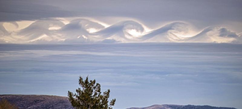
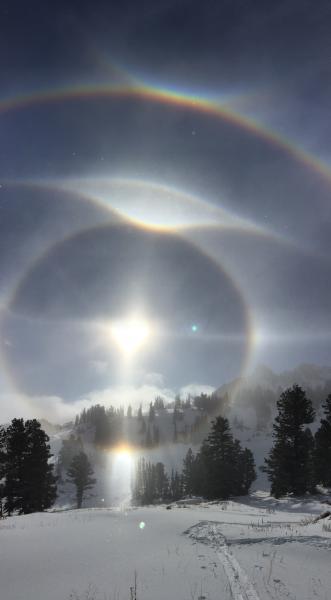
current conditions Skies are mostly cloudy, mountain temps are in the teens, and winds are from the north and northwest and generally less than 15mph. Thursday night's quick shot-in-the-arm offered roughly 5" or so and fell with just a touch of wind during and after frontal passage. Riding conditions are good, but thin. Snow on the ground sits at 1-2'. A couple photos that were jaw-dropping over the last couple days. Brad Peterson caught rotor waves above Snowbasin on the 10th. Also called Kelvin-Helmholtz waves - these shear-driven waves are fairly rare- and were noted during the pre-frontal environment. Below that are photos yesterday by long time observer Bill Brandt, also touring in the Ogden backcountry - these sun dogs are, essentially the refraction light from ice crystals in the atmosphere.
|
 |
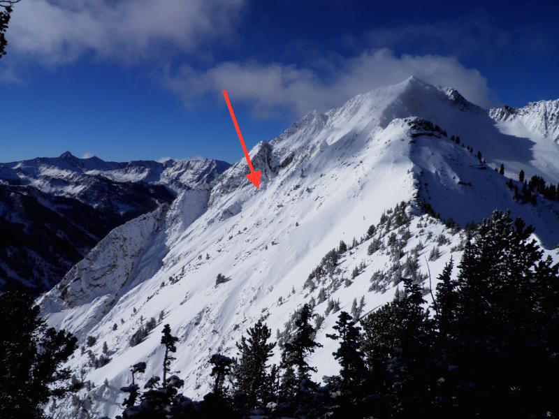
recent activity Sluffing noted on south facing Superior above Little Cottonwood Canyon and a small natural wind pocket noted in Ogden. Note how in each avalanche below, your overall risk is greatly amplified by the terrain. The avalanches in and of themselves are not particularly threatening...it's what happens when you get knocked off your feet or ride that makes the difference. A good example of Risk equating to likelihood and consequence. (Photos White/Davis)
Otherwise, minor cracking and collapsing noted in the backcountry, but limited to isolated wind pillows. Avalanche teams noted touchy new wind drifts with the new snow yesterday.
|
| type | aspect/elevation | characteristics |
|---|

|

|
LIKELIHOOD
 LIKELY
UNLIKELY
SIZE
 LARGE
SMALL
TREND
 INCREASING DANGER
SAME
DECREASING DANGER
|
|
description
Again, risk is always inherent in mountain travel. Shallow sluffs, isolated wind pockets, and thin snowpack conditions may pose isolated hazard to a backcountry traveler today. |
| type | aspect/elevation | characteristics |
|---|

|
|
LIKELIHOOD
 LIKELY
UNLIKELY
SIZE
 LARGE
SMALL
TREND
INCREASING DANGER
SAME
DECREASING DANGER
|
|
description
By and large, it's not a matter of if, but when. We generally have a poor snowpack structure due to the lack of snowfall and cold temperatures. Kory Davis well illustrates the Ogden snowpack below (which is similar to the central Wasatch). The 4-6" of snow from Thursday night wasn't enough to tip the balance and activate the various weaknesses in the snowpack. Until then, our Persistent Slab problem will lie dormant, waiting for the next storm.
|
 |
weather We'll have partly to mostly cloudy skies today with generally light northerly winds. Temps will be in the low to mid-20s. For Sunday, we'll see a warming trend and increasing west to southwest winds ahead of what looks to be a more potent storm for Sunday night into early Tuesday. Totals up to and over a foot of snow are possible. I'll take a closer look at the weather and update our Mountain Weather forecast by early afternoon. |
| general announcements Remember your information can save lives. If you see anything we should know about, please participate in the creation of our own community avalanche advisory by submitting snow and avalanche conditions. You can also call us at 801-524-5304, email by clicking HERE, or include #utavy in your tweet or Instagram. To get help in an emergency (to launch a rescue) in the Wasatch, call 911. Be prepared to give your GPS coordinates or the run name. Dispatchers have a copy of the Wasatch Backcountry Ski map. If you trigger an avalanche in the backcountry, but no one is hurt and you do not need assistance, please notify the nearest ski area dispatch to avoid a needless response by rescue teams. Thanks. Salt Lake and Park City – Alta Central (801-742-2033), Canyons Resort/PCMR Dispatch (435)615-1911 Snowbasin Resort Dispatch (801-620-1017), Powder Mountain Dispatch (801-745-3772 x 123). Sundance Dispatch (801-223-4150) EMAIL ADVISORY If you would like to get the daily advisory by email you will need to subscribe here. DAWN PATROL Hotline updated daily by 5-530am - 888-999-4019 option 8. Twitter Updates for your mobile phone - DETAILS UDOT canyon closures: LINK TO UDOT, or on Twitter, follow @UDOTavy, @CanyonAlerts or @AltaCentral Utah Avalanche Center mobile app - Get your advisory on your iPhone along with great navigation and rescue tools. Wasatch Powderbird Guides Blog/Itinerary for the Day. Lost or Found something in the backcountry? - http://nolofo.com/ To those skinning uphill at resorts: it is your responsibility to know the resort policy on uphill travel. You can see the uphill travel policy for each resort here. IMPORTANT: Before skinning or hiking at a resort under new snow conditions, check in with Ski Patrol. Resorts can restrict or cut off access if incompatible with control and grooming operations. Benefit the Utah Avalanche Center when you shop from Backcountry.com or REI: Click this link for Backcountry.com or this link to REI, shop, and they will donate a percent of your purchase price to the UAC. Both offer free shipping (with some conditions) so this costs you nothing! Benefit the Utah Avalanche Center when you buy or sell on ebay - set the Utah Avalanche Center as a favorite non-profit in your ebay account here and click on ebay gives when you buy or sell. You can choose to have your seller fees donated to the UAC, which doesn't cost you a penny. This information does not apply to developed ski areas or highways where avalanche control is normally done. This advisory is from the U.S.D.A. Forest Service, which is solely responsible for its content. This advisory describes general avalanche conditions and local variations always exist. |