| Please join us at the 23rd annual Black Diamond Fall Fundraiser Party Thursday Sept 15. Tickets are on sale now here, at the Black Diamond store & at REI. Special bonus raffle for online ticket purchasers! |
| Please join us at the 23rd annual Black Diamond Fall Fundraiser Party Thursday Sept 15. Tickets are on sale now here, at the Black Diamond store & at REI. Special bonus raffle for online ticket purchasers! |
| Advisory: Ogden Area Mountains | Issued by Evelyn Lees for Friday - December 11, 2015 - 6:57am |
|---|

|
bottom line The avalanche danger is MODERATE on all wind-drifted slopes approaching 35 degrees or steeper. There is also a moderate danger for slides breaking into weak, sugary snow – most widespread on slopes facing northwest through easterly. Getting caught in a slide is especially dangerous with our shallow snowpack, due to the likelihood of a rough ride along the ground and rocks.
|
 |
special announcement
|
 |
current conditions We’ll call it a storm, for the lack of anything better these last few weeks. Snow totals include 4 to 7” in the upper elevations of the Cottonwoods and on the Park City side, with 2 to 4” in the Ogden and Provo area mountains. Skies are mostly cloudy this morning, and temperatures are in the teens and low 20s. The winds are very light – averaging less than 5 mph.
It’s just enough new snow to cover and hide the rocks and logs once again, and the snow continues to be mostly unsupportable for snow machines off the packed roads and trails. |
 |
recent activity No new avalanches have been reported from the backcountry for the past few days. |
| type | aspect/elevation | characteristics |
|---|

|
|
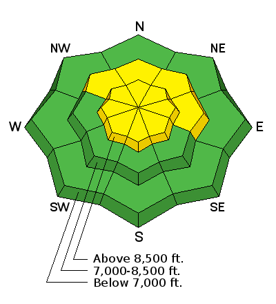
LIKELIHOOD
 LIKELY
UNLIKELY
SIZE
 LARGE
SMALL
TREND
 INCREASING DANGER
SAME
DECREASING DANGER
|
|
description
You will want to avoid any wind drifts that built up overnight before the winds died down. Most of the drifts will be found in the upper elevation terrain and along ridge lines, with more isolated drifts in open bowls and in mid elevation terrain. Gully walls and mid-slope break overs are the sort of terrain features that also collect snow into drifts. If you find a pocket of denser snow, especially if it’s cracking, it’s an indication you’re on a wind-drifted slope.
If you do trigger a wind slab and get the snow moving, it could step down or gouge into the facets. |
| type | aspect/elevation | characteristics |
|---|

|
|
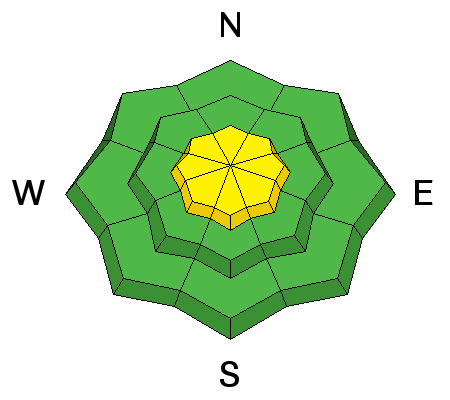
LIKELIHOOD
LIKELY
UNLIKELY
SIZE
 LARGE
SMALL
TREND
 INCREASING DANGER
SAME
DECREASING DANGER
|
|
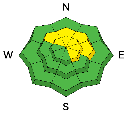
description
Again, any triggered small slide has the potential to break into the sugary weak snow closer to the ground, resulting in a deeper slide. I expect these slides to be “pockety”, perhaps 50 to 100’ wide, but that’s still large enough to catch and carry a person. If you hear a collapsing or whoomphing sound, immediately get off of and out from under steep slopes – it’s an indication the faceted weak layer has been overloaded. |
 |
weather Skies will remain mostly cloudy today, with occasional very light snow showers. 10,000’ temperatures will remain in the mid teens, and the northerly winds will be very light, generally in the 5-10 mph range, with gusts less than 25 mph. Expect similar weather on Saturday, with temperatures warming on Sunday ahead of the next storm – on track for Sunday night into Monday. |
general announcements
|


