| Please join us at the 23rd annual Black Diamond Fall Fundraiser Party Thursday Sept 15. Tickets are on sale now here, at the Black Diamond store & at REI. Special bonus raffle for online ticket purchasers! |
| Please join us at the 23rd annual Black Diamond Fall Fundraiser Party Thursday Sept 15. Tickets are on sale now here, at the Black Diamond store & at REI. Special bonus raffle for online ticket purchasers! |
| Advisory: Ogden Area Mountains | Issued by Evelyn Lees for Saturday - November 28, 2015 - 7:05am |
|---|

|
bottom line The avalanche danger is generally LOW today; there is an isolated MODERATE danger along the high ridge lines for scattered wind drifts, which could be triggered in steep terrain. The shallow snow pack makes getting caught in even a small slide dangerous, as you would get dragged along the ground, scrapping rocks.
|
 |
current conditions Under cloudy skies and scattered snow flurries, temperatures are in the single digits this morning, with a few stations struggling into the low teens. Overnight, most locations picked up a trace of low-density snow, with 2 inches in the Provo area mountains and upper Cottonwoods. The wind direction is variable and speeds very low – averaging 5 to 10 mph, and less than 20 mph even across the highest peaks in the Ogden area mountains. The shallow snow pack is less than 1 1/2 feet deep in the Ogden area mountains, and hitting rocks and logs is likely on many slopes. I spent time in the Ogden area mountains yesterday, and found a very shallow and weak snow pack. Observation HERE. |
 |
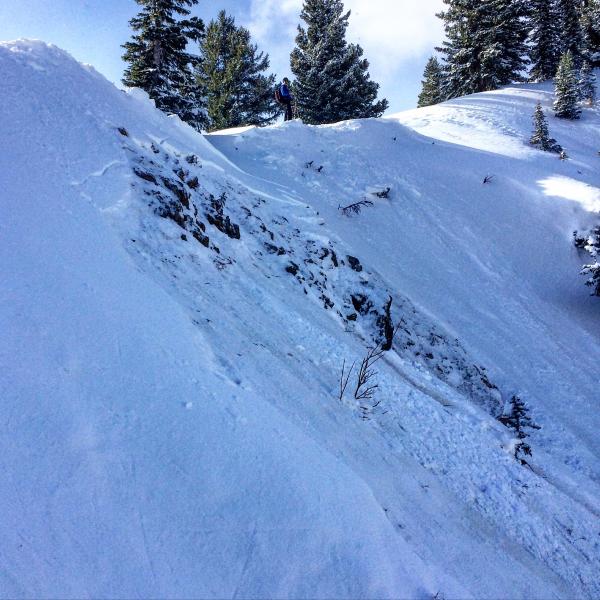
recent activity There was one intentionally triggered wind slab yesterday, which quickly stepped down to the weak facets on the ground. It was on a steep, northerly facing slope along the Silver Fork ridge line in the Salt Lake area mountains – 10 inches deep by 30’ wide. Mark White photo below, complete observation HERE.
|
| type | aspect/elevation | characteristics |
|---|

|
|
LIKELIHOOD
 LIKELY
UNLIKELY
SIZE
 LARGE
SMALL
TREND
 INCREASING DANGER
SAME
DECREASING DANGER
|
|
description
Our weak snowpack just can’t handle much. The shallow wind drifts created by just a few hours of faster wind speeds yesterday were sensitive and cracky. If you get one of these drifts moving, it’s likely to break down to the ground. Yesterday’s drifts were isolated to the ridgelines, where the winds blew the strongest. Again today, watch for any cracking in denser snow layers, and avoid these drifts on steep slopes. While on a variety of aspects, they are mostly likely to step to the ground on northwest through easterly facing slopes. |
 |
weather Skies will be mostly cloudy through Sunday night, with intermittent light snowfall. A trace to a few inches of low-density fluff is possible today and again tonight, especially north of I-80. Wind speeds are forecast to remain very light for the next 24 hours – generally less than 5 mph, with the highest peaks occasionally reaching 15 mph averages. 10,000’ temperatures will struggle to get out of the single digits, 8,000’ temperatures will warm into the teens. Sunday afternoon, there will be a shift to a moist northwest flow, which could bring a few more inches of snow. This will be followed by another dry looking week. |
| general announcements Remember your information can save lives. If you see anything we should know about, please participate in the creation of our own community avalanche advisory by submitting snow and avalanche conditions. You can also call us at 801-524-5304, email by clicking HERE, or include #utavy in your tweet or Instagram. To get help in an emergency (to launch a rescue) in the Wasatch, call 911. Be prepared to give your GPS coordinates or the run name. Dispatchers have a copy of the Wasatch Backcountry Ski map. If you trigger an avalanche in the backcountry, but no one is hurt and you do not need assistance, please notify the nearest ski area dispatch to avoid a needless response by rescue teams. Thanks. Salt Lake and Park City – Alta Central (801-742-2033), Canyons Resort/PCMR Dispatch (435)615-1911 Snowbasin Resort Dispatch (801-620-1017), Powder Mountain Dispatch (801-745-3772 x 123). Sundance Dispatch (801-223-4150) EMAIL ADVISORY If you would like to get the daily advisory by email you will need to subscribe here. DAWN PATROL Hotline updated daily by 5-530am - 888-999-4019 option 8. Twitter Updates for your mobile phone - DETAILS UDOT canyon closures: LINK TO UDOT, or on Twitter, follow @UDOTavy, @CanyonAlerts or @AltaCentral Utah Avalanche Center mobile app - Get your advisory on your iPhone along with great navigation and rescue tools. Wasatch Powderbird Guides Blog/Itinerary for the Day. Lost or Found something in the backcountry? - http://nolofo.com/ To those skinning uphill at resorts: it is your responsibility to know the resort policy on uphill travel. You can see the uphill travel policy for each resort here. IMPORTANT: Before skinning or hiking at a resort under new snow conditions, check in with Ski Patrol. Resorts can restrict or cut off access if incompatible with control and grooming operations. Benefit the Utah Avalanche Center when you shop from Backcountry.com or REI: Click this link for Backcountry.com or this link to REI, shop, and they will donate a percent of your purchase price to the UAC. Both offer free shipping (with some conditions) so this costs you nothing! Benefit the Utah Avalanche Center when you buy or sell on ebay - set the Utah Avalanche Center as a favorite non-profit in your ebay account here and click on ebay gives when you buy or sell. You can choose to have your seller fees donated to the UAC, which doesn't cost you a penny. This information does not apply to developed ski areas or highways where avalanche control is normally done. This advisory is from the U.S.D.A. Forest Service, which is solely responsible for its content. This advisory describes general avalanche conditions and local variations always exist. |