| Please join us at the 23rd annual Black Diamond Fall Fundraiser Party Thursday Sept 15. Tickets are on sale now here, at the Black Diamond store & at REI. Special bonus raffle for online ticket purchasers! |
| Please join us at the 23rd annual Black Diamond Fall Fundraiser Party Thursday Sept 15. Tickets are on sale now here, at the Black Diamond store & at REI. Special bonus raffle for online ticket purchasers! |
| Advisory: Ogden Area Mountains | Issued by Evelyn Lees for Saturday - November 21, 2015 - 6:58am |
|---|

|
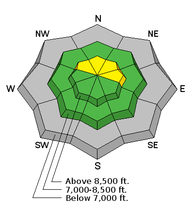
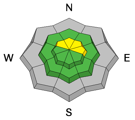
bottom line The avalanche danger is MODERATE today for triggering a slide that would fail near the ground. The most likely slope would be an upper elevation slope facing northwest through east, which is wind-drifted slope or has a deeper, stiffer snowpack.
It is not the time of year to get caught in a slide – even a short ride in a small avalanche would be rough, as you get dragged along the ground, bouncing off rocks, stumps and deadfall.
We will update this forecast Monday or Tuesday, earlier if conditions change.
|
 |
special announcement We will update this forecast Monday or Tuesday, earlier if conditions change. We will post observations daily, and appreciate them all! Most ski areas are closed to uphill traffic as they open or prepare to open. Check in at each resort for their current early season uphill policy. |
 |
current conditions Under clear skies, temperatures have dropped into the teens and single digits. The northerly winds are close to calm, with most stations averaging less than 10 mph. A 2” layer of bouncy graupel caps the shallow snowpack, making it feel more supportable and deeper than it is. The shallow snow depths limit both access and recreation at the moment. If you can get up high, snow depths include:
Packed roads and grassy slopes are the best travel options for avoiding rocks and deadfall. |
 |
recent activity No new avalanche activity was reported yesterday. |
| type | aspect/elevation | characteristics |
|---|

|
|
LIKELIHOOD
 LIKELY
UNLIKELY
SIZE
 LARGE
SMALL
TREND
 INCREASING DANGER
SAME
DECREASING DANGER
|
|
description
There is weak, sugary faceted snow sitting on the ground, however, in most locations there isn’t enough snow on top for it to avalanche.
But on a few wind-drifted slopes at the higher elevations, there is enough weight and stiffness in the upper snow pack for a person could trigger a slide. Any collapsing or whomphing noises are red flags that you are in such an area where you could trigger a slide. This means back off that steep slope and stay on gentle, low angle terrain. If you get cracking in the snow, investigate the depth of the cracks – are they to the ground? On a few lower angle slopes and below cliff bands, graupel may have pooled enough to form a slab over the weak snow. Cracking of the snowpack to the ground, Salt Lake area mountains (Mark White photo)
A great Greg Gagne video clip explaining the current Salt Lke area mountains snowpack, representative of layering where a slide could be triggered in the upper elevations anywhere in the Wasatch mountains :
|
 |
weather High pressure through the weekend will bring two pleasant warm, sunny days. Highs today at 8,000’ will be in the upper 30s, warming into the low 40s for Sunday. 10,000’ temperatures will steadily warm, into the low 30s by Sunday. Winds will remain light through the weekend, averaging less than 20 mph, even along the high ridges.
Of way more interest is next week’s upcoming storm. Confidence is high for a shot of snow and much colder temperatures around Wednesday and Thursday. Confidence is low on the details - timing, evolution and duration of the event. |
| general announcements Remember your information can save lives. If you see anything we should know about, please participate in the creation of our own community avalanche advisory by submitting snow and avalanche conditions. You can also call us at 801-524-5304, email by clicking HERE, or include #utavy in your tweet or Instagram. To get help in an emergency (to launch a rescue) in the Wasatch, call 911. Be prepared to give your GPS coordinates or the run name. Dispatchers have a copy of the Wasatch Backcountry Ski map. If you trigger an avalanche in the backcountry, but no one is hurt and you do not need assistance, please notify the nearest ski area dispatch to avoid a needless response by rescue teams. Thanks. Salt Lake and Park City – Alta Central (801-742-2033), Canyons Resort/PCMR Dispatch (435)615-1911 Snowbasin Resort Dispatch (801-620-1017), Powder Mountain Dispatch (801-745-3772 x 123). Sundance Dispatch (801-223-4150) EMAIL ADVISORY If you would like to get the daily advisory by email you will need to subscribe here. DAWN PATROL Hotline updated daily by 5-530am - 888-999-4019 option 8. Twitter Updates for your mobile phone - DETAILS UDOT canyon closures: LINK TO UDOT, or on Twitter, follow @UDOTavy, @CanyonAlerts or @AltaCentral Utah Avalanche Center mobile app - Get your advisory on your iPhone along with great navigation and rescue tools. Wasatch Powderbird Guides Blog/Itinerary for the Day. Lost or Found something in the backcountry? - http://nolofo.com/ To those skinning uphill at resorts: it is your responsibility to know the resort policy on uphill travel. You can see the uphill travel policy for each resort here. IMPORTANT: Before skinning or hiking at a resort under new snow conditions, check in with Ski Patrol. Resorts can restrict or cut off access if incompatible with control and grooming operations. Benefit the Utah Avalanche Center when you shop from Backcountry.com or REI: Click this link for Backcountry.com or this link to REI, shop, and they will donate a percent of your purchase price to the UAC. Both offer free shipping (with some conditions) so this costs you nothing! Benefit the Utah Avalanche Center when you buy or sell on ebay - set the Utah Avalanche Center as a favorite non-profit in your ebay account here and click on ebay gives when you buy or sell. You can choose to have your seller fees donated to the UAC, which doesn't cost you a penny. This information does not apply to developed ski areas or highways where avalanche control is normally done. This advisory is from the U.S.D.A. Forest Service, which is solely responsible for its content. This advisory describes general avalanche conditions and local variations always exist. |


