25th Annual Black Diamond Fall Fundraising Party
Thursday, September 13; 6:00-10:00 PM; Black Diamond Parking Lot
25th Annual Black Diamond Fall Fundraising Party
Thursday, September 13; 6:00-10:00 PM; Black Diamond Parking Lot
| Advisory: Moab Area Mountains | Issued by Eric Trenbeath for Friday - March 16, 2018 - 6:44am |
|---|


|
bottom line The avalanche danger is MODERATE today. The recent snow load has increased the likelihood for triggering a persistent slab avalanche up to 3' deep on steep slopes right around treeline and above that face NW-N-NE where weak, sugary faceted snow still exists at the base of the snow pack. With daytime heating there is also a MODERATE danger for loose wet avalanches on steep, sun exposed slopes. Look for signs of instability such as sloppy wet snow, roller balls, pinwheels, and point release sluffs. Stay off of and out from under steep slopes when these signs are present.
|
 |
special announcement How does an avalanche accident happen? What is it like to be caught? What can we learn? Read a first-hand account of an avalanche accident in the Meadow Chutes that happened in January. Episode 6 of the UAC podcast "A Conversation with Tom Kimbrough" is live. We explore ideas about lifetime exposure to risk and what role Buddhism has played in his life as a climber, skier, and soon-to-be octogenarian. We talk about what has changed over the years in snow science and the role of mentorship in the world of avalanche forecasting and other professions and pursuits. Check it out on ITunes, Stitcher, the UAC blog. The UAC Marketplace is still open. Our online marketplace still has deals on skis, packs, airbag packs, beacons, snowshoes, soft goods and much more. INSTAGRAM! We now have a UAC-Moab Instagram page. You can find it here....but better yet follow us on your smartphone. Confused? Ask a teenager. |
 |
current conditions About 6" of high density snow has fallen in the mountains since yesterday afternoon with some rain on snow falling early on at lower elevations. Temperatures are in the high teens at 10,000' and in the single digits on Pre Laurel Peak. Winds are light and northwesterly. Not a moment too soon the dense new snow will provide a nice rideable cushion over the old and worn snow surface. Conditions remain thin and many sunny exposed slopes were melted out to the ground before this storm. Sheltered, low angle terrain is where the riding will be best and the bottom will be felt the least. Base depth in Gold Basin: 36" Base depth at Geyser Pass Trailhead: 24" New snow totals in Gold Basin. Snow totals at the Geyser Pass Trailhead, (9600') Wind, temperature, and humidity on Pre Laurel Peak (11,700') Road conditions to Geyser Pass Trailhead: 2-5” of new snow is on the road. Grooming conditions: Gold Basin will be rolled out this afternoons. |
| type | aspect/elevation | characteristics |
|---|

|
|
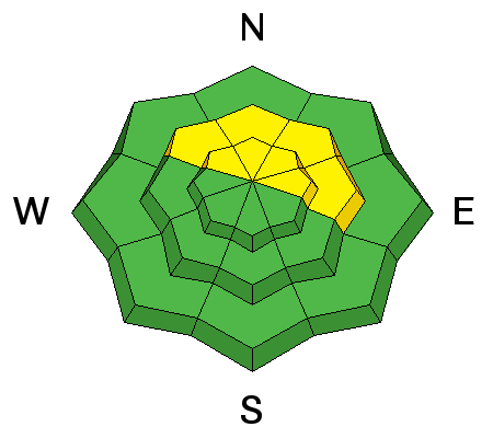
LIKELIHOOD
 LIKELY
UNLIKELY
SIZE
 LARGE
SMALL
TREND
 INCREASING DANGER
SAME
DECREASING DANGER
|
|
description
Almost 3/4 of an inch of water weight has been added to the snow pack since yesterday. I'm uncertain how much this new load will affect buried weak layers, but I suspect some slopes might now be sensitive to the weight of a skier or rider. The most likely areas for triggering an avalanche up to 3' deep can be found in steep terrain right around treeline and above that faces NW-N-E where weak, sugary, faceted snow exists near the ground. Shallow areas along slope margins, or near rock outcroppings create potential trigger spots, and avoidance of this type of terrain is your best bet until we see how the snow pack has handled the new load. With more snow in the forecast for Sunday the likelihood of triggering a persistent slab avalanche will become more prevalent. |
| type | aspect/elevation | characteristics |
|---|

|

|
LIKELIHOOD
LIKELY
UNLIKELY
SIZE
LARGE
SMALL
TREND
 INCREASING DANGER
SAME
DECREASING DANGER
|
|
description
The strong March sun will quickly heat up exposed slopes today, and the fresh snow will be vulnerable to the affects. Look for signs of instability such as sloppy wet snow, roller balls, pinwheels, and point release sluffs. Stay off of and out from under steep slopes when these signs are present. |
 |
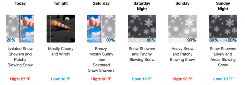
weather Mostly sunny skies and cooler temps will be on tap for today. Clouds will begin to move in tonight ahead of the next storm system that will affect our area on Sunday.
|
| general announcements The UAC has new support programs with Outdoor Research and Darn Tough. Support the UAC through your daily shopping. When you shop at Smith's, or online at Outdoor Research, REI, Backcountry.com, Darn Tough, Patagonia, NRS, Stio, Amazon, and eBay a portion of your purchase will be donated to the FUAC. See our Donate Page for more details on how you can support the UAC when you shop. Benefit the Utah Avalanche Center when you buy or sell on eBay - set the Utah Avalanche Center as a favorite non-profit in your eBay account here and click on eBay gives when you buy or sell. You can choose to have your seller fees donated to the UAC, which doesn't cost you a penny. This information does not apply to developed ski areas or highways where avalanche control is normally done. This advisory is from the U.S.D.A. Forest Service, which is solely responsible for its content. This advisory describes general avalanche conditions and local variations always occur. |