25th Annual Black Diamond Fall Fundraising Party
Thursday, September 13; 6:00-10:00 PM; Black Diamond Parking Lot
25th Annual Black Diamond Fall Fundraising Party
Thursday, September 13; 6:00-10:00 PM; Black Diamond Parking Lot
| Advisory: Moab Area Mountains | Issued by Eric Trenbeath for Tuesday - February 14, 2017 - 6:51am |
|---|

|
bottom line In upper elevation, wind exposed terrain, there remains an isolated, or MODERATE danger on steep slopes that have recent deposits of wind drifted snow. With daytime heating there is also a MODERATE danger for loose, wet avalanches on sun exposed slopes. Otherwise, the avalanche danger is generally LOW.
|
 |
special announcement |
 |
current conditions
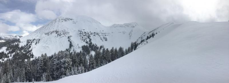
6" of dense new snow over the weekend put a nice refresh on conditions though in most areas you can still feel the underlying snow surface. Moderate ridge top winds have shifted from south to north, blowing the new snow around and depositing fresh drifts on all aspects in upper elevation, wind exposed terrain. At lower elevations, warm temperatures have dampened the snow surface and we will start to see crusts from on sun exposed slopes over the next few days. Dave Garcia was out and about on Monday and sent in this report. For a list of recent observations go here. Wind, temperature and humidity on Pre Laurel Peak. (11,700') Storm totals and temperature in Gold Basin. (10,000') Snow totals, temperature and snow/water equivalent at the Geyser Pass Trailhead. (9600') |
 |
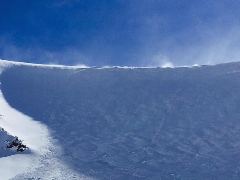
recent activity On Sunday we observed several loose snow sluffs and a few natural cornice falls on upper elevation, northerly aspects. I was also able to intentionally trigger an avalanche with a cornice drop on a north facing, wind loaded slope at 11,600'. Though isolated to the ridge crest, it broke about 350 wide, entraining loose surface snow and running for about 500' vertical. See the full description here.
Horse Creek avalanche (Photo by Dave Garcia) |
| type | aspect/elevation | characteristics |
|---|

|
|
LIKELIHOOD
 LIKELY
UNLIKELY
SIZE
 LARGE
SMALL
TREND
 INCREASING DANGER
SAME
DECREASING DANGER
|
|
description
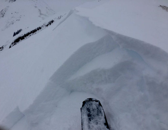
Winds over the past couple of days have blown from all directions, and with plenty of loose snow available for transport, newly deposited wind slabs have formed on all aspects in upper elevation, wind exposed terrain. Though mostly shallow and isolated to ridge crests, one triggered could boss you around in steeper, more radical terrain. Look for signs of instability such as cracking in the snow surface, and avoid areas with recent deposits of wind drifted snow on the leeward sides of ridge crests and terrain features.
On Sunday, I found plenty of wind slabs such as this along upper elevation, northerly facing ridge crests. By dropping down out of the wind affected area you can find loose, settled powder with little to no danger. |
| type | aspect/elevation | characteristics |
|---|

|
|
LIKELIHOOD
LIKELY
UNLIKELY
SIZE
LARGE
SMALL
TREND
 INCREASING DANGER
SAME
DECREASING DANGER
|
|
description
As the the sun peaks out over the next couple of days, it will turn the loose, dry snow lying around into loose, wet snow that wants to slide off. Be alert to changing conditions on sun exposed slopes, and look for signs of instability such as roller balls, pinwheels, and wet, sloppy snow. |
 |
weather Tuesday Mostly cloudy, then gradually becoming sunny, with a high near 33. Northeast wind 5 to 10 mph. Tuesday Night Mostly clear, with a low around 28. Northeast wind around 10 mph. Wednesday Sunny, with a high near 38. East northeast wind 5 to 10 mph becoming west southwest in the morning. Wednesday Night Clear, with a low around 33. East northeast wind 5 to 10 mph becoming west southwest after midnight. Thursday Sunny, with a high near 40. Thursday Night A 40 percent chance of snow after 11pm. Partly cloudy, with a low around 28. Friday A chance of rain and snow before noon, then a chance of rain between noon and 3pm, then a chance of rain and snow after 3pm. Partly sunny, with a high near 36. |
| general announcements Road conditions: The road to Geyser Pass Trailhead is plowed with a mix of packed snow, dirt, and mud at lower elevations. If you are getting out into the mountains, we love to hear from you! You can SUBMIT OBSERVATIONS ONLINE If you would like to have avalanche advisories emailed to you, SIGN UP HERE Support the Utah Avalanche Center just by buying groceries! Do you buy groceries at City Market? When you register your Kroger rewards card with their Community Rewards program, they will donate to the Utah Avalanche Center whenever you make a purchase. It's easy, only takes a minute, and doesn't cost you anything. Details here. Benefit the Utah Avalanche Center when you shop from Backcountry.com or REI: Click this link for Backcountry.com or this link to REI, shop, and they will donate a percent of your purchase price to the UAC. Both offer free shipping (with some conditions) so this costs you nothing! The information in this advisory is from the US Forest Service which is solely responsible for its content. This advisory describes general avalanche conditions and local variations always occur. |