25th Annual Black Diamond Fall Fundraising Party
Thursday, September 13; 6:00-10:00 PM; Black Diamond Parking Lot
25th Annual Black Diamond Fall Fundraising Party
Thursday, September 13; 6:00-10:00 PM; Black Diamond Parking Lot
| Advisory: Moab Area Mountains | Issued by Eric Trenbeath for Sunday - January 15, 2017 - 6:46am |
|---|

|
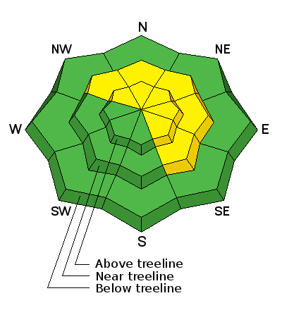
bottom line The avalanche danger is MODERATE today and heightened avalanche conditions exist on specific terrain features. Primary areas of concern continue to be steep, wind loaded, upper elevation slopes that face NW-N-E. Evaluate slopes carefully and avoid areas that have deep deposits of wind drifted snow. Pay special attention to slopes that have steep convexities and blind break-overs - this type of terrain can lure you far down slope, well below where an avalanche is likely to fracture.
|
 |
special announcement Road Conditions: Grand County plowed on Friday. 2" of new snow fell overnight. 4wd is recommended to access Geyser Pass Trailhead. Backcountry 101 Avalanche Class We will be offering a Backcountry 101 avalanche class on Feb 3, 4. This course will include a night classroom session and a day in the field. Cost is $125 with proceeds to benefit the Utah Avalanche Center Moab. For more information or to sign up go here. |
 |
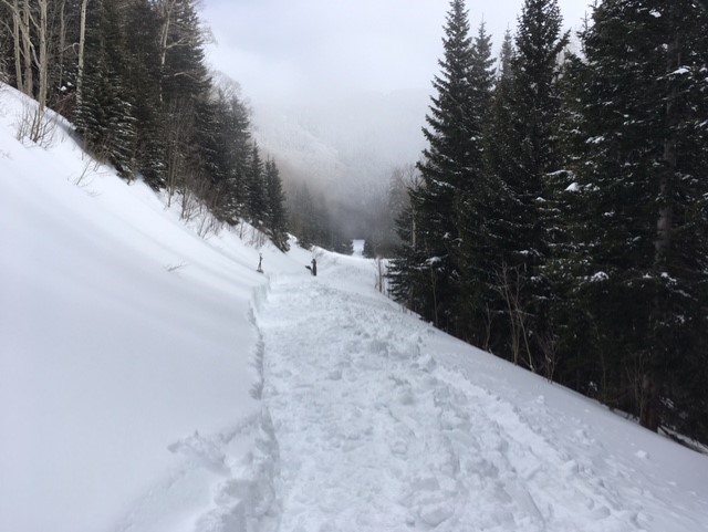
current conditions The mountains received 2" of new snow overnight and SE winds have been on the increase blowing in the 20 - 30 mph range with gusts as high as 40 along ridge tops. They backed off the last hour and are averaging 15 mph. It's 22 degrees on Pre Laurel Peak and a balmy 31 at the Geyser Pass trailhead. Yesterday was a great day to be out in the mountains with calm winds, occasional sun, and fresh powder snow. Upper elevations received a foot or more of snow from the Thu-Fri storm and excellent conditions can be found below tree line and in sheltered areas. Wind exposed terrain has taken a hit with scoured surfaces prevailing on SE-S-SW aspects. The flip side is heavy loading on slopes that face the other side of the compass. Dave Garcia was up on Laurel yesterday and submitted the photos below as well as this observation. Base depth in Gold Basin: 57" Storm totals and temperature in Gold Basin.(10,000') Wind, temperature and humidity on Pre Laurel Peak.(11,700') Snow totals, temperature and snow/water equivalent at the Geyser Pass Trailhead. (9600')
Wind scoured snow prevails on southerly aspects such as this SW facing slope on the skiers right side of the Funnel. (Dave Garcia photo)
Northerly facing aspects are heavily wind loaded such as this NW facing slope on the skiers left side of the Funnel. Note the drifted appearance and pillowy looking areas of wind deposited snow. (Dave Garcia photo) |
 |
recent activity |
| type | aspect/elevation | characteristics |
|---|

|
|
LIKELIHOOD
 LIKELY
UNLIKELY
SIZE
 LARGE
SMALL
TREND
 INCREASING DANGER
SAME
DECREASING DANGER
|
|
description
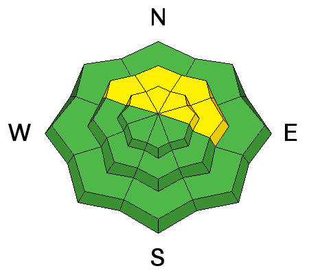
Strong south winds, and 2' of snow since Monday, have formed deep drifts, and layer upon layer of wind slabs on slopes that face the north half of the compass. These wind slabs have gained strength and will be stubborn to trigger, but steep, wind loaded slopes should still be treated with caution if not avoided. Pay special attention to steep convexities with blind break overs. This type of terrain can lure you far down slope to where a triggered avalanche will offer little opportunity for escape. |
| type | aspect/elevation | characteristics |
|---|

|
|
LIKELIHOOD
LIKELY
UNLIKELY
SIZE
 LARGE
SMALL
TREND
 INCREASING DANGER
SAME
DECREASING DANGER
|
|
description
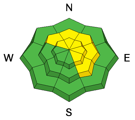
Buried layers of weak faceted snow, sometimes associated with a crust, can be found on most aspects at mid and upper elevations. How reactive they are varies from slope to slope, and about the only way you can be certain is to dig down and test them. Steep, upper elevation, wind loaded slopes that face the north half of the compass are particularly suspect. In these areas it is possible that a triggered wind slab could step down into a buried weak layer causing a deeper and more dangerous avalanche. |
 |
weather Today will see lingering clouds and a chance for snow showers before high pressure builds the first of the week. A stormy pattern returns to the region by Thursday. Today Snow likely, mainly before 11am. Areas of fog before 7am. Otherwise, cloudy, with a high near 28. East southeast wind 5 to 10 mph becoming north in the afternoon. Chance of precipitation is 70%. Total daytime snow accumulation of 1 to 3 inches possible. Tonight A 20 percent chance of snow before 4am. Mostly cloudy, with a low around 17. North wind 5 to 10 mph. M.L.King Day Mostly cloudy, then gradually becoming sunny, with a high near 25. North northeast wind 10 to 15 mph. Monday Night Mostly clear, with a low around 14. North wind around 10 mph. Tuesday Sunny, with a high near 27. North wind around 10 mph. Tuesday Night Partly cloudy, with a low around 18. Wednesday Mostly sunny, with a high near 29. |
| general announcements Road Conditions: Grand County plowed on Friday. This morning you may encounter an inch or two on the road.a.m. Grooming: Matt and Travis worked overtime yesterday to dig out drifts on the Gold Basin Road and to groom in there from the parking lot. Thanks guys!
If you are getting out into the mountains, we love to hear from you! You can SUBMIT OBSERVATIONS ONLINE If you would like to have avalanche advisories emailed to you, SIGN UP HERE Benefit the Utah Avalanche Center when you shop from Backcountry.com or REI: Click this link for Backcountry.com or this link to REI, shop, and they will donate a percent of your purchase price to the UAC. Both offer free shipping (with some conditions) so this costs you nothing! Benefit the Utah Avalanche Center when you buy or sell on ebay - set the Utah Avalanche Center as a favorite non-profit in your ebay account here and click on ebay gives when you buy or sell. You can choose to have your seller fees donated to the UAC, which doesn't cost you a penny. The information in this advisory is from the US Forest Service which is solely responsible for its content. This advisory describes general avalanche conditions and local variations always occur. |