25th Annual Black Diamond Fall Fundraising Party
Thursday, September 13; 6:00-10:00 PM; Black Diamond Parking Lot
25th Annual Black Diamond Fall Fundraising Party
Thursday, September 13; 6:00-10:00 PM; Black Diamond Parking Lot
| Advisory: Moab Area Mountains | Issued by Eric Trenbeath for Thursday - January 12, 2017 - 7:30am |
|---|

|
bottom line The avalanche danger remains CONSIDERABLE in upper elevation wind exposed terrain. The danger is most acute on steep slopes that face N-NE-E, but cross loading has affected slopes on all aspects. Avoid slopes steeper than about 30 degrees that have recent deposits of wind drifted snow. At mid elevations the avalanche danger is MODERATE. Low elevation terrain offers mostly LOW danger.
|
 |
special announcement Road Conditions: Grand County has no plans for plowing today. Significant snow totals this week have all been above the Geyser Pass Trailhead and only an inch or so has fallen at the parking lot. Some drifting has occurred at the last bend but it hasn't proven a significant barrier to access. Backcountry 101 Avalanche Course We will be offering a Backcountry 101 avalanche class on Feb 3, 4. This course will include a night classroom session and a day in the field. Cost is $125 with proceeds to benefit the Utah Avalanche Center Moab. For more information or to sign up go here. |
 |
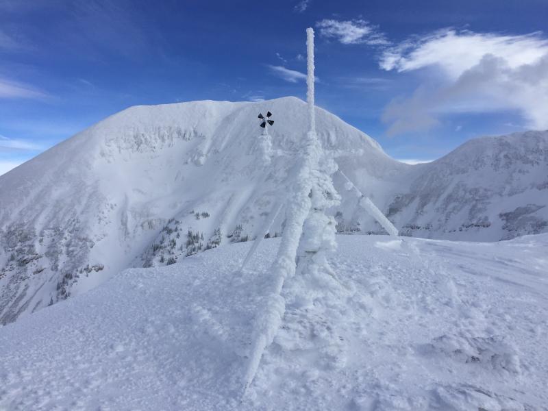
current conditions Avalanche conditions are tricky and the snow surface isn't talking to us a whole lot. But strong southerly winds have deposited large amounts of snow down slope on upper elevation N-NE-E facing slopes and cross loading has occurred on all other aspects. Buried weak layers of faceted snow are reactive to stability tests, but the dense surface snow more evenly distributes your weight, making it harder for a rider to affect these weak layers. But if you find the right spot, you could quickly find yourself in a slide 2-3' deep. With more snow and wind in the forecast, continue to avoid steep, wind loaded terrain. Check out this report from Dave Garcia.
This Dave Garcia photo illustrates cross loading patterns on Mount Mellenthin. Note the scoured areas alternating with wind loaded areas.
Got rime? (Dave Garcia photo) Storm totals and temperature in Gold Basin.(10,000') Wind, temperature and humidity on Pre Laurel Peak.(11,700') Snow totals, temperature and snow/water equivalent at the Geyser Pass Trailhead. (9600') |
 |
recent activity |
| type | aspect/elevation | characteristics |
|---|

|
|
LIKELIHOOD
 LIKELY
UNLIKELY
SIZE
 LARGE
SMALL
TREND
 INCREASING DANGER
SAME
DECREASING DANGER
|
|
description
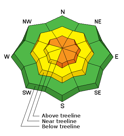
Wind slabs on top of wind slabs exist at upper-mid to upper elevations, and snow has been deposited further down slope than is usual. The danger will be most acute on upper elevation slopes that face N-NE-E, but with winds of this intensity cross loading is a factor and you may encounter wind slabs on all aspects. Suspect smooth rounded pillows and look for cracking in the snow surface. Avoid slopes steeper than about 30 degrees where wind loading has occurred. |
| type | aspect/elevation | characteristics |
|---|

|
|
LIKELIHOOD
LIKELY
UNLIKELY
SIZE
 LARGE
SMALL
TREND
 INCREASING DANGER
SAME
DECREASING DANGER
|
|
description
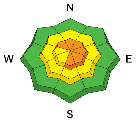
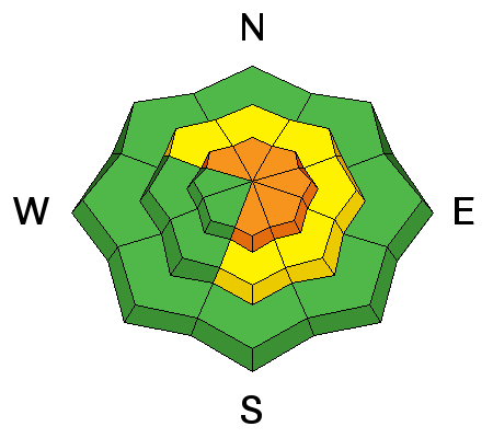
Just when we were almost out of the woods, a new round of persistent slab problems has presented themselves. On Tuesday I found reactive weak layers of buried faceted snow on a NE facing aspect several hundred feet below tree line at 10,600'. Dave Garcia's party found a reactive faceted weak layer under a melt-freeze crust on a south facing slope at 11,600'. A 2' deep wind slab was sitting on top. The layer failed and propagated at 11 under an extended column test (ECTP 11). For a video of those results check out this link. This weak layer from a snowpit dug on a NE facing aspect at 10,600' failed on a compression test with a score of 6 (CT6 Q1). It failed at 9 and propagated on an extended column test. (ECTP 9). |
 |
weather Today Snow. High near 26. Breezy, with a south southwest wind 15 to 20 mph, with gusts as high as 30 mph. Chance of precipitation is 90%. Total daytime snow accumulation of 3 to 5 inches possible. Tonight Snow. Low around 21. South southwest wind 10 to 15 mph. Chance of precipitation is 90%. New snow accumulation of 5 to 9 inches possible. Friday Snow. High near 27. South wind 10 to 15 mph. Chance of precipitation is 80%. New snow accumulation of 3 to 5 inches possible. Friday Night A 50 percent chance of snow. Cloudy, with a low around 20. South wind 5 to 10 mph. New snow accumulation of 2 to 4 inches possible. Saturday A 50 percent chance of snow. Cloudy, with a high near 29. South wind 5 to 10 mph becoming east in the afternoon. Saturday Night A 50 percent chance of snow. Mostly cloudy, with a low around 20. Sunday Snow likely, mainly before 11am. Mostly cloudy, with a high near 26. Chance of precipitation is 60%. |
| general announcements Road Conditions: Expect to find accumulating and drifting snow on the road today at the upper end. Grooming: Trails are scheduled to be groomed this afternoon. If you are getting out into the mountains, we love to hear from you! You can SUBMIT OBSERVATIONS ONLINE If you would like to have avalanche advisories emailed to you, SIGN UP HERE Benefit the Utah Avalanche Center when you shop from Backcountry.com or REI: Click this link for Backcountry.com or this link to REI, shop, and they will donate a percent of your purchase price to the UAC. Both offer free shipping (with some conditions) so this costs you nothing! Benefit the Utah Avalanche Center when you buy or sell on ebay - set the Utah Avalanche Center as a favorite non-profit in your ebay account here and click on ebay gives when you buy or sell. You can choose to have your seller fees donated to the UAC, which doesn't cost you a penny. The information in this advisory is from the US Forest Service which is solely responsible for its content. This advisory describes general avalanche conditions and local variations always occur. |