| Please join us at the 23rd annual Black Diamond Fall Fundraiser Party Thursday Sept 15. Tickets are on sale now here, at the Black Diamond store & at REI. Special bonus raffle for online ticket purchasers! |
| Please join us at the 23rd annual Black Diamond Fall Fundraiser Party Thursday Sept 15. Tickets are on sale now here, at the Black Diamond store & at REI. Special bonus raffle for online ticket purchasers! |
| Advisory: Moab Area Mountains | Issued by Eric Trenbeath for Monday - April 4, 2016 - 7:05am |
|---|

|
bottom line The avalanche danger is generally LOW but unstable snow may exist on isolated terrain features. As the days heat up, continue to watch for signs of wet snow instability such as roller balls, pinwheels, and sloppy wet snow, and stay off of and out from under steep slopes when these signs are present. In areas of more extreme radical terrain, it may still be possible to trigger an errant wind slab, or have a cornice break off beneath you. Continue to practice safe travel techniques and carry appropriate rescue gear.
|
 |
special announcement This advisory is based on field work performed on the weekend of April 2, 3 and weather observations taken on Monday, April 4. It is to be used as a baseline for forming your own danger analysis for the upcoming week. A weak system will move through the area on Tuesday, but little change in avalanche conditions are expected. Use the weather links provided under the current conditions section to stay abreast of wind, temperature and new snowfall. The next advisory will be updated on Friday, April 8. |
 |
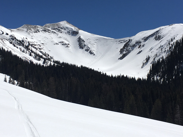
current conditions It was quite a weekend in the La Sals wiith sunny skies, and mostly stable snow. People were out and about everywhere skiing the big lines with impunity and without incident. As of Sunday afternoon, dry, settled powder could still be found on upper elevation, northerly aspects, while corn snow was happening on south facing slopes. Clouds and a slight chance of snow on Tuesday will put a damper on the corn, but sunny skies return on Wednesday. Expect the powder snow to diminish day by day, and use the weather links below to stay abreast of current condiitons.
Winds, temperature and humidity on Pre-Laurel Peak New snow totals, temperature and humidity in Gold Basin Total snow depth and temperature at Geyser Pass Trailhead
|
 |
recent activity
|
| type | aspect/elevation | characteristics |
|---|

|

|
LIKELIHOOD
 LIKELY
UNLIKELY
SIZE
 LARGE
SMALL
TREND
 INCREASING DANGER
SAME
DECREASING DANGER
|
|
description
The avalanche danger is generally LOW but unstable snow may exist on isolated terrain features. As the days heat up, continue to watch for signs of wet snow instability such as roller balls, pinwheels, and sloppy wet snow, and stay off of and out from under steep slopes when these signs are present. In areas of more extreme radical terrain, it may still be possible to trigger an errant wind slab, or have a cornice break off beneath you. Continue to practice safe travel techniques and carry appropriate rescue gear. |
 |
weather Monday will be another beautiful day in the mountains. On Tuesday, a fast moving and weakening system will clip by to the north bringing clouds, gusty winds, and a slight chance for snow. Sunny skies return on Wednesday, with another system looming for the weekend. Monday Mostly sunny, with a high near 42. Southwest wind 5 to 15 mph, with gusts as high as 25 mph. Monday Night Isolated snow showers after 4am. Mostly cloudy, with a low around 26. West southwest wind around 15 mph, with gusts as high as 30 mph. Chance of precipitation is 20%. Sunny skies return on Wednesday, and by Friday, clouds will begin to move in ahead of another system brewing out beyond the horizon. Tuesday A 30 percent chance of snow showers, mainly before noon. Some thunder is also possible. Mostly sunny, with a high near 33. Windy, with a west northwest wind 15 to 20 mph increasing to 25 to 30 mph in the afternoon. Winds could gust as high as 45 mph. Tuesday Night Partly cloudy, with a low around 18. Windy, with a northwest wind 20 to 30 mph becoming north northeast 10 to 20 mph in the evening. Winds could gust as high as 45 mph. Wednesday Sunny, with a high near 36. East wind 10 to 15 mph becoming north in the afternoon. Wednesday Night Mostly clear, with a low around 26. Thursday Sunny, with a high near 45. Thursday Night Partly cloudy, with a low around 30. Friday A slight chance of snow showers after noon. Partly sunny, with a high near 43. |
| general announcements Road Conditions: The road is plowed down to the dirt and will get muddy in the afternoon. Grooming Conditons: The road into Gold Basin has been packed out with roller and is suitable for cross country skiing. It's quite rough for skating. To post an observation go here. You can view Moab observations here. You can also give me a call on my cell phone at 801-647-8896 To receive this advisory by email go here. This information does not apply to developed ski areas or highways where avalanche control is normally done. This advisory is from the U.S.D.A. Forest Service, which is solely responsible for its content. This advisory describes general avalanche conditions and local variations always exist. |