| Please join us at the 23rd annual Black Diamond Fall Fundraiser Party Thursday Sept 15. Tickets are on sale now here, at the Black Diamond store & at REI. Special bonus raffle for online ticket purchasers! |
| Please join us at the 23rd annual Black Diamond Fall Fundraiser Party Thursday Sept 15. Tickets are on sale now here, at the Black Diamond store & at REI. Special bonus raffle for online ticket purchasers! |
| Advisory: Moab Area Mountains | Issued by Eric Trenbeath for Thursday - March 31, 2016 - 6:56am |
|---|

|
bottom line Today the avalanche danger is MODERATE in areas where you can detect recent deposits of wind drifted snow. The danger is most pronounced on upper elevation slopes that have a northerly aspect. Though most of the sensitivity has gone out of the new snow, today remains a good day to mind your slope angles and keep it under 35 degrees. And as the strong warm sun hits the new snow today, the danger for wet slide activity will rise to MODERATE on steep, sun exposed slopes. Look for signs of instability such as roller balls and pinwheels, and stay off of and out from under steep slopes when these signs are present. .
|
 |
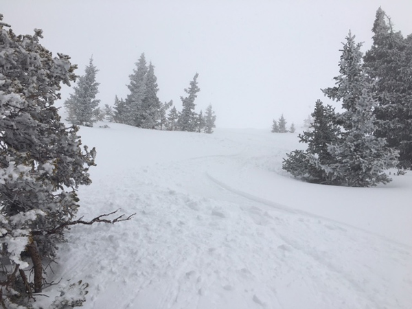
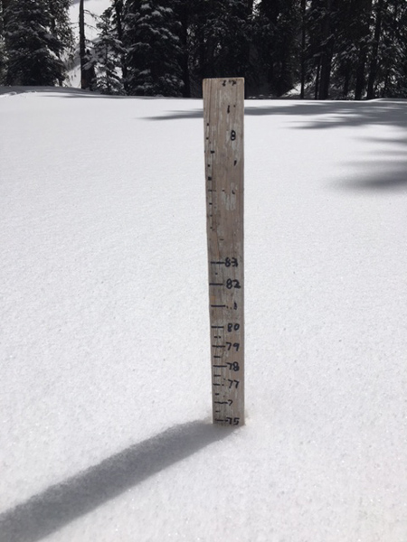
current conditions Skies are clear this morning and northerly ridge top winds are mostly light, avearging around 10 mph. It's a wintery 18 degrees at the Geyser Pass Trailhead and 10 degrees on Pre Laurel Peak. Tuesday's storm brought a return to winter in the La Sal Mountains and we picked up more than a foot of snow above 10,000. Cloud cover and cold temperatures kept a lid on heating yesterday and the snow stayed mostly dry. When the sun did poke out, the effect was instantaneous, so there may be a few slopes out there that have developed a thin crust. In my travels yesterday I found dense, creamy powder conditions. In some areas underlying crusts could still be felt, primarily on southerly aspects, or in wind swept areas above treeline. Base depth in Gold Basin is 75".
Got winter?
Getting close to the top off the stake! Winds, temperature and humidity on Pre-Laurel Peak New snow totals, temperature and humidity in Gold Basin Total snow depth and temperature at Geyser Pass Trailhead
|
 |
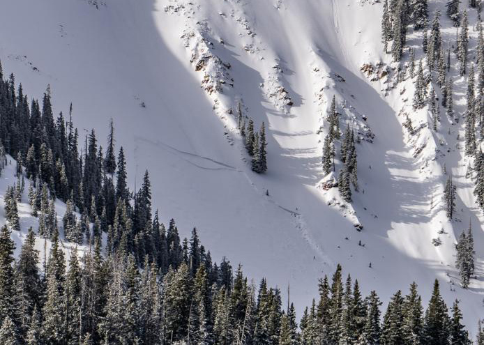
recent activity Several natural avalanches occurred within the new snow during the height of the storm on Tuesday including this one observed by Ryan Schantzenbach in Exxon's Folley. You can read his description here, as well as a report on his travels here. Thanks Ryan. All observed naturals occurred on upper elevation, northerly aspects.
|
| type | aspect/elevation | characteristics |
|---|

|
|
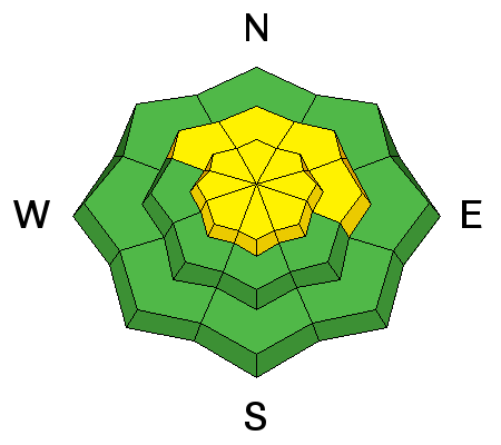
LIKELIHOOD
 LIKELY
UNLIKELY
SIZE
 LARGE
SMALL
TREND
 INCREASING DANGER
SAME
DECREASING DANGER
|
|
description
Most of the sensitivity had settled out by yesterday, and I was surprised not to observe any cracking in the new snow. However, I did notice upside down, hollow feeling slabs 2-3 feet thick along the lee sides of upper elevation ridge crests. Though stubborn, I think you could still trigger these slabs in steep terrain, and you may have to get a little ways down the slope to do it. As a result, I would scale things back for a few days and avoid steep slopes that have smooth rounded deposits of wind drifted snow. Pay extra caution to slopes with terrain traps and steep convexities on them. |
| type | aspect/elevation | characteristics |
|---|

|
|
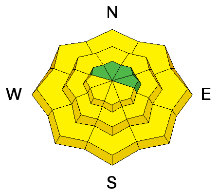
LIKELIHOOD
LIKELY
UNLIKELY
SIZE
 LARGE
SMALL
TREND
 INCREASING DANGER
SAME
DECREASING DANGER
|
|
description
The snow stayed mostly dry yesterday, and when the sun hits it today, it will quickly warm and saturate it raising the potential for wet slide activity on sun exposed slopes. This danger will be most pronounced on slopes that face E-S-W, but this time of year, mid and lower elevation northerly aspects are not immune. Be on the lookout for signs of instability such as roller balls, pinwheels, and loose snow sluffing off the rocks. Stay off of and out from under steep slopes when these signs are present. |
 |
weather Today Snow showers likely, mainly between 1pm and 3pm. Patchy fog before 8am. Otherwise, mostly cloudy, with a high near 23. North wind 10 to 15 mph. Chance of precipitation is 60%. Total daytime snow accumulation of around an inch possible. Tonight A 50 percent chance of snow showers, mainly before 11pm. Mostly cloudy, with a low around 14. North northeast wind around 15 mph, with gusts as high as 25 mph. New snow accumulation of less than one inch possible. Friday Sunny, with a high near 26. North northeast wind 10 to 15 mph. Friday Night Mostly clear, with a low around 19. North northeast wind around 15 mph. Saturday Sunny, with a high near 34. Northeast wind 5 to 10 mph. Saturday Night Mostly clear, with a low around 24. Sunday Sunny, with a high near 37. |
| general announcements Road Conditions: Thanks very much to grand County for plowing the road yesterday! Grooming Conditons: The road into Gold Basin has been packed out with roller and is suitable for cross country skiing. It's quite rough and soft for skating. To post an observation go here. You can view Moab observations here. You can also give me a call on my cell phone at 801-647-8896 To receive this advisory by email go here. This information does not apply to developed ski areas or highways where avalanche control is normally done. This advisory is from the U.S.D.A. Forest Service, which is solely responsible for its content. This advisory describes general avalanche conditions and local variations always exist. |