| Please join us at the 23rd annual Black Diamond Fall Fundraiser Party Thursday Sept 15. Tickets are on sale now here, at the Black Diamond store & at REI. Special bonus raffle for online ticket purchasers! |
| Please join us at the 23rd annual Black Diamond Fall Fundraiser Party Thursday Sept 15. Tickets are on sale now here, at the Black Diamond store & at REI. Special bonus raffle for online ticket purchasers! |
| Advisory: Moab Area Mountains | Issued by Eric Trenbeath for Wednesday - March 30, 2016 - 6:47am |
|---|

|
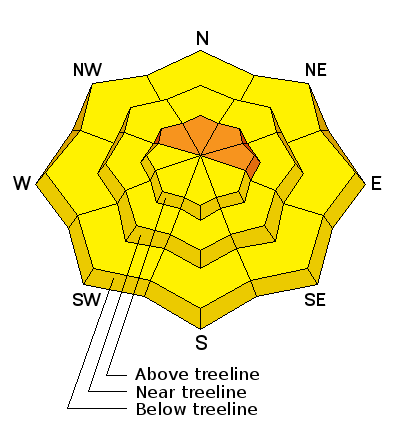
bottom line Today the avalanche danger is CONSIDERABLE in upper elevation, wind exposed terrain, on slopes that face NW-N-E. Deep drifts have formed in these areas and human triggered avalanches are likely. Outside of these areas, the avalanche danger is MODERATE for triggering a recent wind drift or avalanche within the new snow. If the sun pokes out at all, the danger for wet slide activity will also rise to MODERATE on sun exposed slopes. Today is a good day to manage terrain wisely and keep your slope angle down to around 30 degrees.
|
 |
current conditions Wow, March is going out like a Lion! Yesterday's forecasted 2-4" quickly turned into more than a foot of new snow, most of it falling between 5:00 am and noon. Geyser Pass Trailhead shows 8" of new with just over an inch water, while Gold Basin is reporting 13". I expect we could have up to 16" up high. Strong southwest winds blew in the 20-30 mph range with gusts into the 50's during most of the snowfall period. Winds have been steadily decreasing overnight and are currently in the single digits and westerly. And finally, it's also going to feel like winter up there today. 10,000' temperatures are in the teens and it's 8 degrees on Pre-Laurel Peak. Winds, temperature and humidity on Pre-Laurel Peak New snow totals, temperature and humidity in Gold Basin Total snow depth and temperature at Geyser Pass Trailhead
|
 |
recent activity
|
| type | aspect/elevation | characteristics |
|---|

|
|
LIKELIHOOD
 LIKELY
UNLIKELY
SIZE
 LARGE
SMALL
TREND
 INCREASING DANGER
SAME
DECREASING DANGER
|
|
description
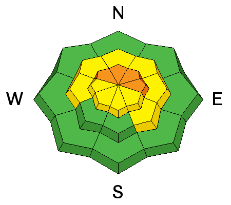
Lot's of snow was being blown around yesterday. Though they won't be quite as sensitive today, deep wind drifts on leeward aspects will pose a significant danger, particularly in upper elevation, wind exposed terrain that faces the north half of the compass. Today will be a very good day to avoid steep slopes in these areas as human triggered avalanches are likely. |
| type | aspect/elevation | characteristics |
|---|

|
|
LIKELIHOOD
 LIKELY
UNLIKELY
SIZE
LARGE
SMALL
TREND
INCREASING DANGER
SAME
DECREASING DANGER
|
|
description
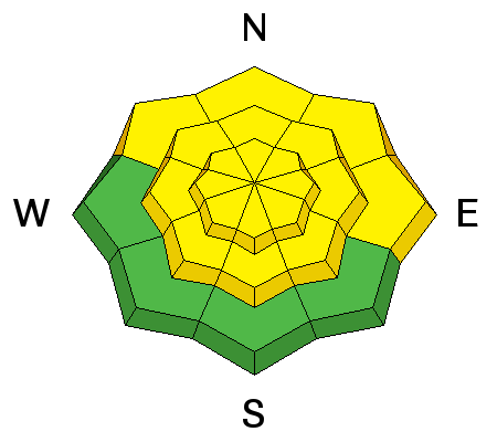
Sensitivity within the new snow can take a day or two to stabilize. Today there will be a moderate danger for triggering avalanches within the new snow on all aspects on slopes steeper than about 35 degrees. |
| type | aspect/elevation | characteristics |
|---|

|
|
LIKELIHOOD
 LIKELY
UNLIKELY
SIZE
LARGE
SMALL
TREND
 INCREASING DANGER
SAME
DECREASING DANGER
|
|
description
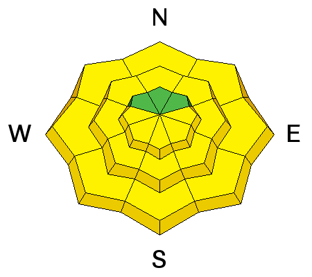
Though cloudy skies and lingering showers are forecasted today, things are already breaking up and skies are mostly clear over Moab this morning. If the sun pokes out at all today, it will quickly warm and saturate the new dry snow raising the potential for wet slide activity on sun exposed slopes. This danger will be most pronounced on slopes that face E-S-W, but this time of year, mid and lower elevation northerly aspects are not immune. Be on the lookout for signs of instability such as roller balls, pinwheels, and loose snow sluffing off the rocks. Stay off of and out from under steep slopes when these signs are present. |
 |
weather Today Snow showers. High near 20. West southwest wind 10 to 15 mph becoming northwest in the afternoon. Chance of precipitation is 90%. Total daytime snow accumulation of 1 to 2 inches possible. Tonight A 50 percent chance of snow showers, mainly before 11pm. Mostly cloudy, with a low around 12. North northeast wind around 15 mph. New snow accumulation of less than a half inch possible. Thursday A 50 percent chance of snow showers. Partly sunny, with a high near 23. North wind 10 to 15 mph. New snow accumulation of less than one inch possible. Thursday Night A 30 percent chance of snow showers before midnight. Mostly cloudy, with a low around 13. North northeast wind around 15 mph, with gusts as high as 25 mph. Friday Sunny, with a high near 26. North northeast wind 10 to 15 mph, with gusts as high as 25 mph. |
| general announcements Road Conditions: Expect to find several inches of new snow on the road this morning, increasing with elevation. To post an observation go here. You can view Moab observations here. You can also give me a call on my cell phone at 801-647-8896 To receive this advisory by email go here. This information does not apply to developed ski areas or highways where avalanche control is normally done. This advisory is from the U.S.D.A. Forest Service, which is solely responsible for its content. This advisory describes general avalanche conditions and local variations always exist. |


