| Please join us at the 23rd annual Black Diamond Fall Fundraiser Party Thursday Sept 15. Tickets are on sale now here, at the Black Diamond store & at REI. Special bonus raffle for online ticket purchasers! |
| Please join us at the 23rd annual Black Diamond Fall Fundraiser Party Thursday Sept 15. Tickets are on sale now here, at the Black Diamond store & at REI. Special bonus raffle for online ticket purchasers! |
| Advisory: Moab Area Mountains | Issued by Eric Trenbeath for Sunday - March 27, 2016 - 6:47am |
|---|

|
bottom line The avalanche danger is generally LOW but unstable snow may exist on isolated terrain features. Maintain awareness of possible instabilities, particularly in areas of steep, rocky, and radical terrain on upper elevation slopes that face N-NE-E. With daytime heating, the potential also exists for shallow, loose wet slides. Watch for signs of instability such as rollerballs, pinwheels, or sloppy wet snow and stay off of, and out from under steep slopes if these signs are present.
|
 |
current conditions
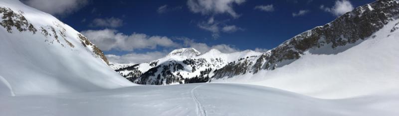
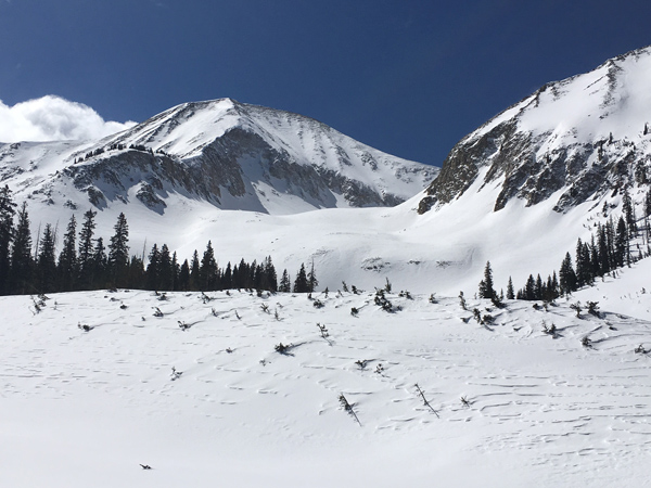
Mid level clouds are again hanging over the area this morning but they should quickly dissipate as the day progresses. After a breezy week, ridgetop winds overnight finally backed off into the single digits out of the NW. Temps are very cold this morning, it's 6 degrees on Pre Laurel Peak and 14 at the Geyser Pass Trailhead. I made a foray up into Red Snow Cirque yesterday and found conditions to be variable at best. Moderate but relentless NW winds throughout the week have wrecked most of the powder in exposed, upper elevation terrain. Temps remained cold all day, but the strong March sun has crusted over any surface it has touched. It will however, be a beautiful day to get out in the mountains. Travel is fast and easy, and the quality of the spring light in the mountains this time of year makes for some pretty impressive mountain scenery.
Winds have kind of had their way with things, but it sure is gorgeous out!
Winds, temperature and humidity on Pre-Laurel Peak New snow totals, temperature and humidity in Gold Basin Total snow depth and temperature at Geyser Pass Trailhead
|
 |
recent activity
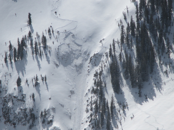
The new snow and wind from the Tue-Wed storm filled in this repeat running slide path just enough for these two unknown folks to pull it out again on Thursday. This is the same pocket that was triggered a couple of weeks ago that resulted in a serious injury. Note the areas of wind drifted snow, and the very steep, convex, and rocky nature of the terrain where the slab released. It looks like a wind slab that stepped down into weak, sugary, faceted snow. This is a NE facing slope at around 11,000'.
|
| type | aspect/elevation | characteristics |
|---|

|
|
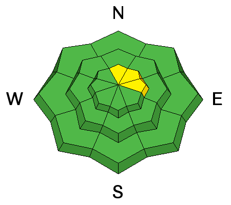
LIKELIHOOD
 LIKELY
UNLIKELY
SIZE
 LARGE
SMALL
TREND
 INCREASING DANGER
SAME
DECREASING DANGER
|
|
description
The avalanche danger is generally low, but unstable snow may exist on isolated terrain features. Here are some problems to remain aware of: Wind Slabs: Active winds throughout the week moved snow around and formed drifts on the lee sides of ridge crests and terrain features in the upper elevations. These slabs have mostly gained strength, but even an isolated, shallow pocket released over a cliff could have dire consequences. Continue to be on the lookout for errant wind slabs, particularly in areas of steep, rocky, and radical terrain. Persistent Slab: Much more the exception than the rule, it still may be possible to trigger a persistent slab on buried facets in areas where the snowpack is weak and shallow. You may still find this problem in areas of very steep, radical, and rocky terrain that has a N-NE-E aspect. Repeat running slide paths also remain suspect. Wet Loose: The strong sun today will heat up the top few inches of snow and we may some wet loose sluffs. These will be quite shallow and shouldn't pose much of a problem, but be alert to signs of instability such as roller balls, pinwheels, and wet sloppy snow on sun exposed slopes. |
 |
weather It will be a beautiful day in the mountains with mostly sunny skies and temps at 10,000' near 40 degrees. Southwest winds will be on the increase ahead of an approaching Pacific storm system that will move into the region by Monday night. This looks to be primarily affecting areas just to our north but we could see a few inches out of it. Today Mostly sunny, with a high near 40. Southwest wind 10 to 15 mph. Tonight Mostly cloudy, with a low around 26. Windy, with a south southwest wind 15 to 20 mph increasing to 25 to 30 mph after midnight. Winds could gust as high as 40 mph. Monday A chance of rain and snow after noon. Areas of blowing dust after noon. Mostly cloudy, with a high near 45. Windy, with a south southwest wind 25 to 35 mph, with gusts as high as 55 mph. Chance of precipitation is 30%. Monday Night Snow likely, mainly after midnight. Areas of blowing dust before midnight. Cloudy, with a low around 22. Very windy, with a south southwest wind 35 to 40 mph, with gusts as high as 60 mph. Chance of precipitation is 60%. New snow accumulation of 1 to 3 inches possible. Tuesday Snow likely. Cloudy, with a high near 29. Very windy, with a south southwest wind 35 to 40 mph decreasing to 25 to 30 mph in the afternoon. Winds could gust as high as 55 mph. Chance of precipitation is 70%. Tuesday Night A 50 percent chance of snow. Mostly cloudy, with a low around 13. Breezy. Wednesday A 40 percent chance of snow. Partly sunny, with a high near 27. |
| general announcements Road Conditions: The road has mostly melted off down to the dirt and it's getting muddy in the afternoon. Grooming: Grooming is wrapping up for the season but the lower meadow and the road into Gold Basin were packed out yesterday. To post an observation go here. You can view Moab observations here. You can also give me a call on my cell phone at 801-647-8896 To receive this advisory by email go here. This information does not apply to developed ski areas or highways where avalanche control is normally done. This advisory is from the U.S.D.A. Forest Service, which is solely responsible for its content. This advisory describes general avalanche conditions and local variations always exist. |