| Please join us at the 23rd annual Black Diamond Fall Fundraiser Party Thursday Sept 15. Tickets are on sale now here, at the Black Diamond store & at REI. Special bonus raffle for online ticket purchasers! |
| Please join us at the 23rd annual Black Diamond Fall Fundraiser Party Thursday Sept 15. Tickets are on sale now here, at the Black Diamond store & at REI. Special bonus raffle for online ticket purchasers! |
| Advisory: Moab Area Mountains | Issued by Eric Trenbeath for Friday - March 25, 2016 - 6:51am |
|---|

|
bottom line The avalanche danger is MODERATE in upper elevation, wind exposed terrain where recent deposits of wind drifted snow pose the greatest threat. It is also possible that a triggered wind slab will step down into buried, weak, faceted snow, particularly on slopes that have avalanched repeatedly, or in areas of rocky, extreme terrain that has a N-NE-E aspect. Venturing into this type of terrain significantly raises the likelihood and consequences for triggering a potentially dangerous avalanche. Out of the wind affected terrain, the avalanche danger is generally LOW.
|
 |
current conditions NW winds have been mostly light for the past 24 hours but are showing a slight bump into the 15 -20 mph range as of 6:00 a.m. They are expected to increase throughout the day as a weak system on a northwest flow moves through the area. It's currently 24 degrees at the Geyser Pass trailhead and 15 on Pre Laurel Peak. Powder snow can still be found in sheltered areas, but a variety of hard surfaces still exist underneath the most recent snow. Winds, temperature and humidity on Pre-Laurel Peak New snow totals, temperature and humidity in Gold Basin Total snow depth and temperature at Geyser Pass Trailhead
|
 |
recent activity
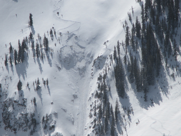
The new snow and wind from the Tue-Wed storm filled in this repeat running slide path just enough for these two unknown folks to pull it out again yesterday. This is the same pocket that was triggered a couple of weeks ago that resulted in a serious injury. Note the areas of wind drifted snow, and the very steep, convex, and rocky nature of the terrain where the slab released. It looks like a wind slab that stepped down into weak, sugary, faceted snow. This is a NE facing slope at around 11,000'.
|
| type | aspect/elevation | characteristics |
|---|

|
|
LIKELIHOOD
 LIKELY
UNLIKELY
SIZE
 LARGE
SMALL
TREND
 INCREASING DANGER
SAME
DECREASING DANGER
|
|
description
You need to remain on the lookout for wind slabs on the lee sides of upper elevation ridge crests and terrain features. Look for signs of instability such as cracking in the snow surface, and avoid steep slopes with smooth, rounded deposits of wind drifted snow. |
| type | aspect/elevation | characteristics |
|---|

|

|
LIKELIHOOD
 LIKELY
UNLIKELY
SIZE
 LARGE
SMALL
TREND
 INCREASING DANGER
SAME
DECREASING DANGER
|
|
description
Though more the exception than the rule, Thursday's human triggered avalanche demonstrates that triggered wind slabs still have the potential to step down into sugary, faceted snow in areas where the snowpack is shallow and weak. Repeat running slide paths are especially suspect, as are areas of steep and rocky, more radical terrain that has a N-NE-E aspect. |
 |
weather A weak storm system on a NW flow will move through the area later today bringing clouds, an increase in winds, and a chance for snow. A second wave will move into the area tonight and tomorrow bringing us a better chance for a few inches of snow. A brief ridge builds on Sunday with another system slated for early next week. Today A 50 percent chance of snow, mainly after 2pm. Areas of blowing snow. Partly sunny, with a high near 30. Blustery, with a west northwest wind 20 to 25 mph, with gusts as high as 40 mph. Total daytime snow accumulation of less than a half inch possible. Tonight Snow. Areas of blowing snow before 1am. Low around 11. Blustery, with a northwest wind 15 to 25 mph, with gusts as high as 40 mph. Chance of precipitation is 80%. New snow accumulation of 1 to 3 inches possible. Saturday Snow likely, mainly before noon. Some thunder is also possible. Areas of blowing snow after noon. Mostly cloudy, with a high near 22. Blustery, with a north northwest wind 15 to 20 mph, with gusts as high as 30 mph. Chance of precipitation is 70%. New snow accumulation of 2 to 4 inches possible. Saturday Night Partly cloudy, with a low around 16. Blustery, with a north wind 15 to 20 mph becoming west after midnight. Sunday Sunny, with a high near 32. Breezy, with a southwest wind 15 to 20 mph. |
| general announcements Road Conditions: Expect to find a few inches of new snow on the road today. To post an observation go here. You can view Moab observations here. You can also give me a call on my cell phone at 801-647-8896 To receive this advisory by email go here. This information does not apply to developed ski areas or highways where avalanche control is normally done. This advisory is from the U.S.D.A. Forest Service, which is solely responsible for its content. This advisory describes general avalanche conditions and local variations always exist. |